world.wikisort.org - Philippines
Lapu-Lapu City, officially known as the City of Lapu-Lapu (Cebuano: Dakbayan sa Lapu-Lapu; Filipino: Lungsod ng Lapu-Lapu), is a 1st class highly urbanized city in the Central Visayas region of the Philippines. According to the 2020 census, it has a population of 497,604 people. [2]
Lapu-Lapu City | |
|---|---|
Highly urbanized city | |
| City of Lapu-Lapu | |
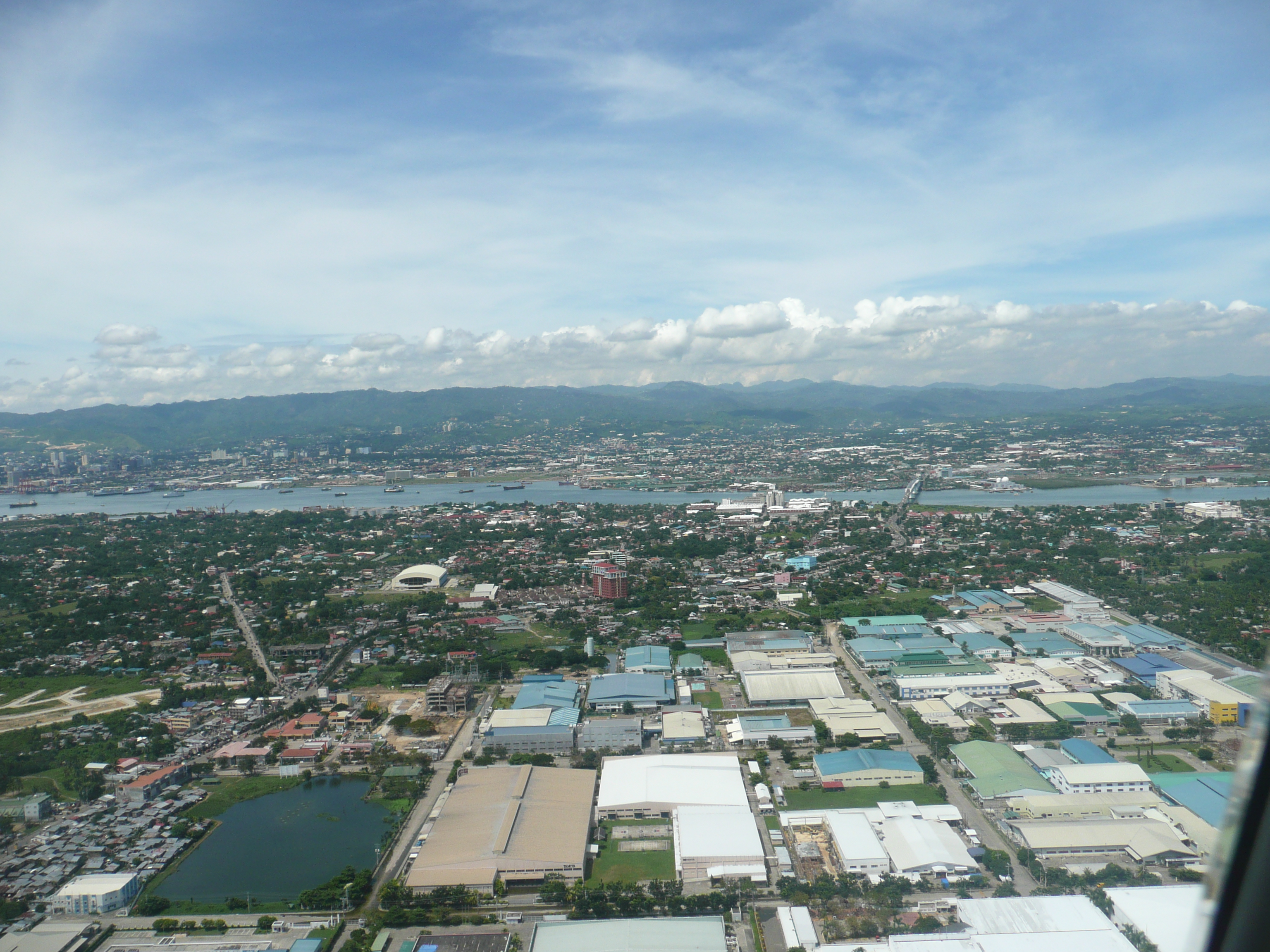 Aerial view over MEPZ–II | |
 Flag  Seal | |
| Nickname: Historic Resort City | |
| Anthem: Dakbayan sa Sidlakan | |
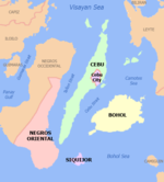
 Map of Central Visayas with Lapu-Lapu City highlighted | |
OpenStreetMap  | |
 Lapu-Lapu City Location within the Philippines | |
| Coordinates: 10°18′46″N 123°56′56″E | |
| Country | Philippines |
| Region | Central Visayas |
| Province | Cebu (geographically only) |
| District | Lone district |
| 1730 |
| Named for | Lapulapu |
| Barangays | 30 (see Barangays |
| Government | |
| • Type | Sangguniang Panlungsod |
| • Mayor | Junard "Ahong" Q. Chan (PDPLBN) |
| • Vice Mayor | Celedonio B. Sitoy (PDPLBN) |
| • Representative | Ma. Cynthia K. Chan (PDPLBN) |
| • City Council | Members |
| • Electorate | 245,395 voters (2022) |
| Area | |
| • Total | 58.10 km2 (22.43 sq mi) |
| Elevation | 70 m (230 ft) |
| Highest elevation | 984 m (3,228 ft) |
| Lowest elevation | −1 m (−3 ft) |
| Population | |
| • Total | 497,604 |
| • Density | 8,600/km2 (22,000/sq mi) |
| • Households | 129,652 |
| Demonym | Oponganon[3] |
| Economy | |
| • Income class | 1st city income class |
| • Poverty incidence | 6.80% (2018)[4] |
| • Revenue | ₱2,687,149,804.74 (2020) |
| • Assets | ₱9,540,823,400.78 (2020) |
| • Expenditure | ₱3,171,375,762.20 (2020) |
| • Liabilities | ₱3,858,570,398.62 (2020) |
| Service provider | |
| • Electricity | Mactan Electric Company (MECO) |
| Time zone | UTC+8 (Philippine Standard Time (PST)) |
| ZIP code | 6015 |
| PSGC | |
| IDD : area code | +63 (0)32 |
| Native languages | Cebuano |
It was formerly known as Opon, the city being renamed to its present name in 1961. It is one of the cities that make up Metro Cebu in the Philippines. It is located in the province of Cebu, administratively independent from the province, but grouped under Cebu by the Philippine Statistics Authority (PSA).
Mactan–Cebu International Airport, the second busiest airport in the Philippines, is located in Lapu-Lapu City.
History

In the 16th century, Mactan Island was colonized by Spain. Augustinian friars founded the town of Opon in 1730, and it became a city in 1961. It was renamed after Datu Lapulapu, the island's chieftain, who led the defeat against the Portuguese explorer Ferdinand Magellan in 1521 in the Battle of Mactan, commemorated at Mactan Shrine in Punta Engaño, where Magellan led a landing party of 40 men to resupply who were set upon by 1,500 locals and slew their captain and a few other men.
The municipality of Opon was founded by the Augustinian missionaries in 1730. It was ceded to the Jesuits in 1737, and later restored to the Augustinians. When the Philippine Revolution spread to the Visayas in 1898, the people organized themselves into local revolutionary units.
During the Filipino-American War, a military government was established. The continued resistance of the people of Cebu prompted the American government to restore military control over the province on July 17, 1901. In 1905, Opon held its first municipal election, and Pascual dela Serna was elected town president.
Following the outbreak of World War II, the presence of bulk oil storage tanks in Opon made the town an object of Japanese raids a week after the outbreak of WWII in December 1941. The enemy aircraft succeeded in blowing up two of about fourteen oil storage tanks in Opon. A unit of the Kawaguchi Detachment of the Japanese Imperial Forces landed on the east coast of Cebu on April 10, 1942. Later, the resistance movement was organized by Colonel James M. Cushing, leader of the southern and central units, and Harry Fenton of the northern unit of the Cebu Resistance Movement.
During the Battle of the Visayas, Victor II operations of the American Division led by Major General William Arnold landed in Cebu on March 26, 1945, and subsequently liberated the province.
Historically, the city includes the site of the Battle of Mactan. On August 1, 1973, by virtue of Presidential Decree No. 2060, President Ferdinand E. Marcos declared the site of the battle a national shrine; the preservation, restoration and/or reconstruction of which shall be under the supervision and control of the National Historical Commission in collaboration with the Department of Tourism. Mactan is also the birthplace of Leonila Dimataga-Garcia, wife of Carlos P. Garcia, the fourth President of the Republic. Leonila Dimataga-Garcia was a relative of the wife of Lapu-Lapu City's former mayor Ernest Weigel Jr. (1992-2001, three terms) who was the richest mayor in Metro Cebu, with a net worth of ₱57 million in the early 2000s.
Cityhood
Congressman Manuel A. Zosa, the representative of the Sixth District of Cebu, sponsored the Bill converting the former municipality of Opon into the present day city of Lapu-Lapu. This was the Republic Act 3134,[5] known as the City Charter of Lapu-Lapu, which was signed on June 17, 1961, by Philippine President Carlos P. Garcia. Lapu-Lapu was inaugurated on December 31, 1961, with Mariano Dimataga, the last municipal mayor, as the first city mayor.[6]
As a fast-growing commercial city, some of its commercial and industrial firms are the General Milling Company, one of the largest in the country; the Cebu Shipyard and Engineering Works, pioneered by Dad Cleland; and the oil companies which resumed their operations after the war. Air transportation for the city is served by the Mactan International Airport.
Highly urbanized city
On January 23, 2007, Lapu-Lapu was proclaimed as HUC via Proclamation No. 1222, signed by President Gloria Macapagal Arroyo. Its plebiscite was held along with Puerto Princesa in Palawan on July 21, 2007. Both of them successfully became highly urbanized cities after majority of their voters voted in favor of conversion. They ranked 31st and 32nd in the country.
Geography
Lapu-Lapu is bounded on the north by the main island of Cebu, to the west by Cebu City and Mactan Channel, on the east by the Camotes Sea, and on the south by the town of Cordova.
The city occupies Mactan Island, a few kilometers off the main island of Cebu. It also has some of the barangays under its jurisdiction on the Olango Island Group. The city is linked to Mandaue on mainland Cebu by the Mactan-Mandaue Bridge and Marcelo Fernan Bridges.
Barangays
Lapu-Lapu comprises 30 barangays:

| PSGC | Barangay | Population | ±% p.a. | Area | PD 2020 | |||||
|---|---|---|---|---|---|---|---|---|---|---|
| 2020 [2] | 2010 [7] | ha | acre | /km2 | /sq mi | |||||
| 072226001 | Agus | 3.9% | 19,525 | 15,767 | 2.05% | |||||
| 072226002 | Babag | 6.2% | 30,839 | 22,756 | 2.93% | 307 | 759 | 10,000 | 26,000 | |
| 072226003 | Bankal | 4.6% | 22,863 | 20,872 | 0.87% | 201 | 497 | 11,000 | 29,000 | |
| 072226004 | Baring | 0.8% | 3,870 | 3,353 | 1.37% | 91 | 225 | 4,300 | 11,000 | |
| 072226005 | Basak | 14.5% | 71,990 | 59,873 | 1.77% | 603 | 1,490 | 12,000 | 31,000 | |
| 072226006 | Buaya | 3.8% | 19,078 | 16,072 | 1.64% | 271 | 670 | 7,000 | 18,000 | |
| 072226007 | Calawisan | 3.2% | 15,740 | 11,454 | 3.06% | 957 | 2,365 | 1,600 | 4,300 | |
| 072226008 | Canjulao | 2.9% | 14,451 | 13,245 | 0.83% | 156 | 385 | 9,300 | 24,000 | |
| 072226011 | Caubian | 0.5% | 2,429 | 2,272 | 0.64% | |||||
| 072226009 | Caw‑oy | 0.4% | 2,226 | 1,837 | 1.84% | 162,900 | 402,542 | 1.4 | 3.5 | |
| 072226010 | Cawhagan | 0.1% | 694 | 638 | 0.80% | 55,900 | 138,134 | 1.2 | 3.2 | |
| 072226012 | Gun‑ob | 7.6% | 37,989 | 31,219 | 1.88% | |||||
| 072226013 | Ibo | 1.7% | 8,318 | 8,126 | 0.22% | |||||
| 072226014 | Looc | 3.1% | 15,411 | 16,016 | −0.37% | |||||
| 072226015 | Mactan | 10.2% | 50,964 | 33,465 | 4.08% | |||||
| 072226016 | Maribago | 3.8% | 18,954 | 16,591 | 1.27% | |||||
| 072226017 | Marigondon | 5.1% | 25,584 | 19,713 | 2.51% | |||||
| 072226018 | Pajac | 4.4% | 22,116 | 17,402 | 2.30% | |||||
| 072226019 | Pajo | 5.2% | 25,845 | 20,999 | 1.99% | |||||
| 072226020 | Pangan‑an | 0.5% | 2,348 | 2,070 | 1.20% | |||||
| 072226021 | Poblacion[lower-alpha 1] | 1.3% | 6,238 | 5,581 | 1.06% | |||||
| 072226022 | Punta Engaño | 2.3% | 11,425 | 8,753 | 2.56% | |||||
| 072226024 | Pusok | 6.6% | 32,791 | 28,810 | 1.24% | |||||
| 072226025 | Sabang | 1.4% | 6,910 | 6,091 | 1.21% | |||||
| 072226031 | San Vicente | 0.8% | 4,209 | 3,854 | 0.84% | |||||
| 072226026 | Santa Rosa | 1.1% | 5,388 | 4,302 | 2.16% | |||||
| 072226027 | Subabasbas | 1.6% | 7,961 | 6,288 | 2.27% | |||||
| 072226028 | Talima | 1.2% | 5,973 | 5,734 | 0.39% | |||||
| 072226029 | Tingo | 0.6% | 3,231 | 3,088 | 0.43% | |||||
| 072226030 | Tungasan | 0.5% | 2,244 | 1,871 | 1.74% | |||||
| Total | 497,604 | 350,467 | 3.39% | 5,810 | 14,357 | 8,600 | 22,000 | |||
Climate
| Climate data for Lapu-Lapu | |||||||||||||
|---|---|---|---|---|---|---|---|---|---|---|---|---|---|
| Month | Jan | Feb | Mar | Apr | May | Jun | Jul | Aug | Sep | Oct | Nov | Dec | Year |
| Average high °C (°F) | 28 (82) |
29 (84) |
30 (86) |
31 (88) |
31 (88) |
30 (86) |
30 (86) |
30 (86) |
30 (86) |
29 (84) |
29 (84) |
28 (82) |
30 (85) |
| Average low °C (°F) | 23 (73) |
23 (73) |
23 (73) |
24 (75) |
25 (77) |
25 (77) |
25 (77) |
25 (77) |
25 (77) |
25 (77) |
24 (75) |
23 (73) |
24 (75) |
| Average precipitation mm (inches) | 70 (2.8) |
49 (1.9) |
62 (2.4) |
78 (3.1) |
138 (5.4) |
201 (7.9) |
192 (7.6) |
185 (7.3) |
192 (7.6) |
205 (8.1) |
156 (6.1) |
111 (4.4) |
1,639 (64.6) |
| Average rainy days | 13.4 | 10.6 | 13.1 | 14.5 | 24.2 | 27.9 | 28.4 | 27.7 | 27.1 | 27.4 | 22.5 | 15.9 | 252.7 |
| Source: Meteoblue (modeled/calculated data, not measured locally)[8] | |||||||||||||
Demographics
| Year | Pop. | ±% p.a. |
|---|---|---|
| 1903 | 14,851 | — |
| 1918 | 20,988 | +2.33% |
| 1939 | 33,426 | +2.24% |
| 1948 | 37,280 | +1.22% |
| 1960 | 48,546 | +2.22% |
| 1970 | 69,268 | +3.61% |
| 1975 | 79,484 | +2.80% |
| 1980 | 98,324 | +4.34% |
| 1990 | 146,194 | +4.05% |
| 1995 | 173,744 | +3.29% |
| 2000 | 217,019 | +4.88% |
| 2007 | 292,530 | +4.20% |
| 2010 | 350,467 | +6.80% |
| 2015 | 408,112 | +2.94% |
| 2020 | 497,604 | +3.98% |
| Source: Philippine Statistics Authority (PSA) [9] [7] [10][11] | ||
Lapu-Lapu's residents mainly speak Cebuano, the local language. Tagalog and English is also widely spoken and understood, due to the influx of foreign nationals in the city. Due to the large number of resorts and retirement homes in the city, as well as the growing number of ESL schools, the city also hosts a number of Japanese, Korean, and Chinese speakers.
Economy

Government

| Years | Mayor |
|---|---|
| 1938-1967 | Mariano Dimataga |
| 1968-1986 | Maximo V. Patalinjug |
| 1986-1988 | Silvestre T. Dignos |
| 1988-1991 | Maximo V. Patalinjug |
| 1992-2001 | Ernest H. Weigel |
| 2001-2010 | Arturo O. Radaza |
| 2010-2019 | Paz C. Radaza |
| 2019- | Junard Q. Chan |
Mariano Dimataga's term was interrupted during the years 1941-1945. Teodulo Tomakin and later Eugenio Araneta were appointed as town mayors. They later escaped from the Japanese, Jorge Tampus took over. During the Allied liberation by the combined Filipino-American forces, year 1945 Mariano Dimataga resumed his interrupted term.
Transportation

Mactan–Cebu International Airport (MCIA) is located in this city, which is connected to mainland Cebu via the Marcelo Fernan Bridge and Mactan-Mandaue Bridges, as well as the Cebu–Cordova Link Expressway (located in the nearby town of Cordova), over the sea separating the Mactan island from the island of Cebu. The airport is the main gateway to Cebu and Central Visayas, serving international flights to various destinations, especially to Singapore, Macau, Hong Kong, South Korea, Japan, and Taiwan. MCIA is also the second busiest airport in the Philippines, after Ninoy Aquino International Airport in Manila.
Gallery
 Poblacion (Opon)
 Lapu-Lapu City highway
 Muelle Osmeña
 Virgen de la Regla Church
 Our Lady of the Rule
 Plantation Bay Resort and Spa
 Skyline of hotel and resorts
 Olango Island Wildlife Sanctuary


Notable people
- Lapulapu - A chieftain of Mactan and the First Philippine National Hero who defeated Magellan.
- Janine Berdin - The grand winner of the second season of Tawag ng Tanghalan.
- Akiko Solon - Finalist of Star Power: Sharon Search For the Next Female Superstar.
See also
- List of renamed cities and municipalities in the Philippines
Notes
- Part of the Poblacion barangay is still called Opon.
References
- "2015 Census of Population, Report No. 3 – Population, Land Area, and Population Density" (PDF). Philippine Statistics Authority. Quezon City, Philippines. Aug 2016. ISSN 0117-1453. Archived (PDF) from the original on May 25, 2021. Retrieved Jul 16, 2021.
- Census of Population (2020). "Region VII (Central Visayas)". Total Population by Province, City, Municipality and Barangay. PSA. Retrieved Jul 8, 2021.
- Inso, Futch Anthony (Jun 28, 2019). "Lapu-Lapu Mayor Chan's non-Oponganon choices for dep't heads slammed". Cebu Daily News. Philippine Daily Inquirer. Archived from the original on Jun 29, 2019. Retrieved Apr 26, 2020.
- "PSA Releases the 2018 Municipal and City Level Poverty Estimates". Philippine Statistics Authority. Dec 15, 2021. Retrieved Jan 22, 2022.
- Republic Act No. 3134, June 17, 1961, "An Act Creating the City Of Lapu-Lapu" elibrary.judiciary.gov.ph
- About Lapu Lapu City
- Census of Population and Housing (2010). "Region VII (Central Visayas)". Total Population by Province, City, Municipality and Barangay. NSO. Retrieved Jun 29, 2016.
- "Lapu-Lapu: Average Temperatures and Rainfall". Meteoblue. Retrieved May 10, 2020.
- Census of Population (2015). "Region VII (Central Visayas)". Total Population by Province, City, Municipality and Barangay. PSA. Retrieved Jun 20, 2016.
- Censuses of Population (1903–2007). "Region VII (Central Visayas)". Table 1. Population Enumerated in Various Censuses by Province/Highly Urbanized City: 1903 to 2007. NSO.
- "Province of Cebu". Municipality Population Data. Local Water Utilities Administration Research Division. Retrieved Dec 17, 2016.
- "Poverty incidence (PI):". Philippine Statistics Authority. Retrieved Dec 28, 2020.
- https://psa.gov.ph/sites/default/files/NSCB_LocalPovertyPhilippines_0.pdf; publication date: 29 November 2005; publisher: Philippine Statistics Authority.
- https://psa.gov.ph/sites/default/files/2003%20SAE%20of%20poverty%20%28Full%20Report%29_1.pdf; publication date: 23 March 2009; publisher: Philippine Statistics Authority.
- https://psa.gov.ph/sites/default/files/2006%20and%202009%20City%20and%20Municipal%20Level%20Poverty%20Estimates_0_1.pdf; publication date: 3 August 2012; publisher: Philippine Statistics Authority.
- https://psa.gov.ph/sites/default/files/2012%20Municipal%20and%20City%20Level%20Poverty%20Estima7tes%20Publication%20%281%29.pdf; publication date: 31 May 2016; publisher: Philippine Statistics Authority.
- https://psa.gov.ph/sites/default/files/City%20and%20Municipal-level%20Small%20Area%20Poverty%20Estimates_%202009%2C%202012%20and%202015_0.xlsx; publication date: 10 July 2019; publisher: Philippine Statistics Authority.
- "PSA Releases the 2018 Municipal and City Level Poverty Estimates". Philippine Statistics Authority. Dec 15, 2021. Retrieved Jan 22, 2022.
Sources
- Gonzales, Glenda R (Dec 2004). "Metro Cebu: A Metropolitan Area in Need of Coordinative Body" (PDF). Discussion Paper. 2004-49. Philippine Institute for Development Studies (PIDS) / Surian sa mga Pag-aaral Pangkaunlaran ng Pilipinas. Retrieved Feb 16, 2016.
External links
Places adjacent to Lapu-Lapu City | ||||||||||||||||
|---|---|---|---|---|---|---|---|---|---|---|---|---|---|---|---|---|
| ||||||||||||||||


| Authority control |
|
|---|
На других языках
[de] Lapu-Lapu City
Lapu-Lapu City ist eine philippinische Stadt (Component City) in der Provinz Cebu. Ihr früherer Name lautete Opon. Sie wurde zu Ehren des philippinischen Nationalhelden in Lapu-Lapu umbenannt und zu seinen Ehren wurde in der Stadt der Lapu-Lapu and Maghellan Shrine erbaut.- [en] Lapu-Lapu City
[ru] Лапу-Лапу (город)
Лапу-Лапу (тагальск. Lungsod ng Lapu-Lapu) — город на Филиппинах, на территории региона Центральные Висайи. Входит в состав провинции Себу. Является частью городской агломерации Себу.Другой контент может иметь иную лицензию. Перед использованием материалов сайта WikiSort.org внимательно изучите правила лицензирования конкретных элементов наполнения сайта.
WikiSort.org - проект по пересортировке и дополнению контента Википедии