world.wikisort.org - Philippines
Calbayog, officially known as the City of Calbayog (Waray: Siyudad han Calbayog; Tagalog: Lungsod ng Calbayog), is a 1st class component city in the province of Samar, Philippines. According to the 2020 census, it has a population of 186,960 people. [3]
Calbayog | |
|---|---|
Component city | |
| City of Calbayog | |
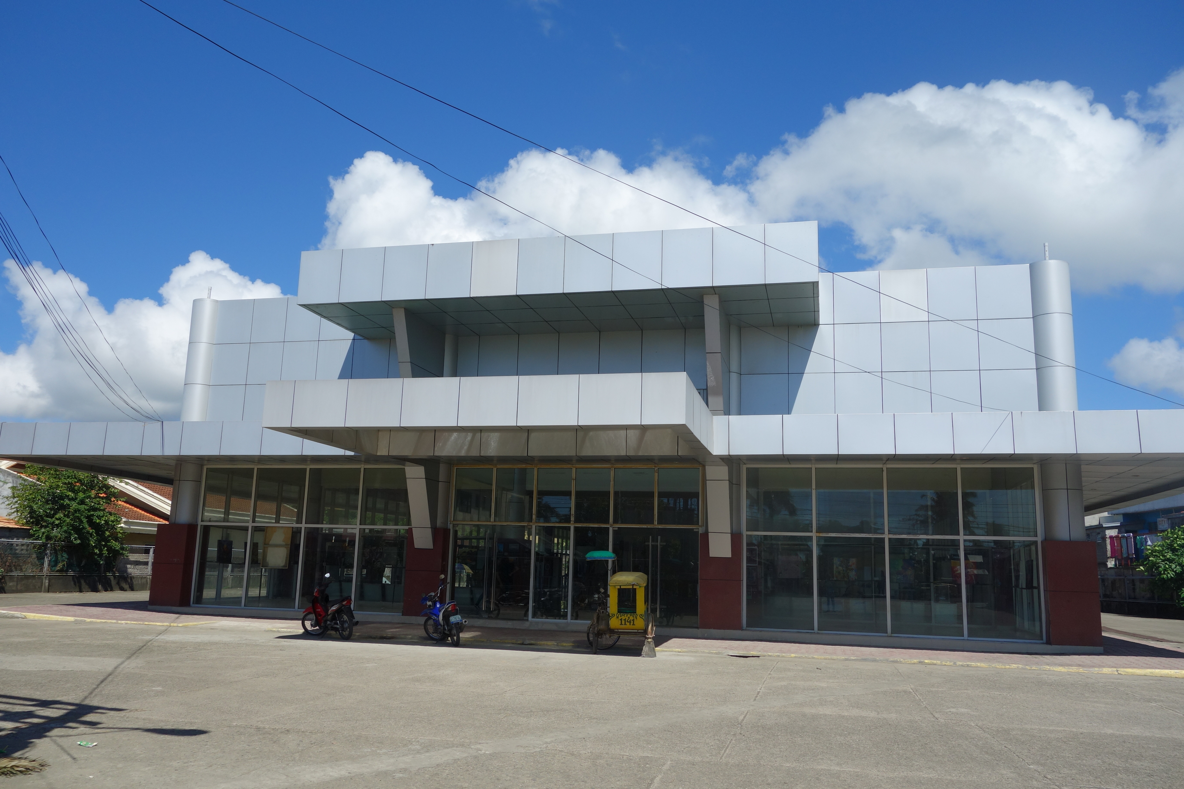
 Aerial view of Calbayog | |
 Flag  Seal | |
Nicknames:
| |
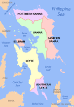
 Map of Samar with Calbayog highlighted | |
OpenStreetMap  | |
 Calbayog Location within the Philippines | |
| Coordinates: 12°04′N 124°36′E | |
| Country | Philippines |
| Region | Eastern Visayas |
| Province | Samar |
| District | 1st district |
| Cityhood | October 16, 1948 |
| Barangays | 157 (see Barangays) |
| Government | |
| • Type | Sangguniang Panlungsod |
| • Mayor | Raymund C. Uy |
| • Vice Mayor | Rex M. Daguman |
| • Representative | Stephen James T. Tan |
| • City Council | List |
| • Electorate | 127,638 voters (2019) |
| Area | |
| • Total | 880.74 km2 (340.06 sq mi) |
| Elevation | 63 m (207 ft) |
| Highest elevation | 851 m (2,792 ft) |
| Lowest elevation | 0 m (0 ft) |
| Population | |
| • Total | 186,960 |
| • Density | 210/km2 (550/sq mi) |
| • Households | 43,030 |
| Economy | |
| • Income class | 1st city income class |
| • Poverty incidence | 23.66% (2018)[4] |
| • Revenue | ₱1,690,970,578.64 (2020) |
| • Assets | ₱4,656,990,118.93 (2020) |
| • Expenditure | ₱1,124,408,450.37 (2020) |
| • Liabilities | ₱828,975,668.59 (2020) |
| Service provider | |
| • Electricity | Samar 1 Electric Cooperative (SAMELCO 1) |
| Time zone | UTC+8 (PST) |
| ZIP code | 6710 |
| PSGC | |
| IDD : area code | +63 (0)55 |
| Native languages | Waray Tagalog |
| Website | www |
It lies along the coastal region of the province stretching about 60 miles (97 km) from the northern tip of the island and 180 miles (290 km) from southern boundaries.
It is the sixth largest city in terms of land and water areas in the Philippines. It is the nineteenth city of the Philippines. In 2010, Calbayog has 35,126 households with a population of 172,778 people, making up 23.6% of the total population of the province of Samar.[5] Calbayog is one of the commercial trade centers in Eastern Visayas. Calbayog is subdivided into three major districts: Calbayog, Tinambacan and Oquendo.
History
Unraveling of Revolutionary Society, Katipunan
After the exile of Rizal in Dapitan, the Katipunan was born in Binondo, Manila. Andres Bonifacio and his men moved heaven and earth to fight against the Spanish government then led by Gob. Heneral Polavieja. The katipunan expanded its membership from Luzon down to the Visayas Region, thereby increasing the number of Katipuneros in a span of one year. Sensing the secret plan of the Katipunan to overthrow the government, the Spanish authorities raided a Binondo printing press where subversive documents were found and confiscated. One of the documents seized was the list of members of the Katipunan. The name Benedicto Nijaga was one in the list, being the collector of revolutionary funds in the area. Upon learning of the arrests, Governor Polavieja ordered the arrest of all suspected members of the Katipunan. Nijaga was arrested together with twelve other katipuneros while campaigning for revolutionary funds. Shortly after they were jailed and reportedly tortured, a trial ensued, reminiscent of that of Rizal and other Filipino nationalists.[6] The 13 men were convicted and sentenced to death. On January 11, 1897, the thirteen were taken to Bagumbayan field under heavy guard. Just before sunrise, the men were executed.[7]
After Spain transferred power to USA
Colegio-Seminario de San Vicente de Paul (now Christ the King College and St. Vincent de Paul Seminary) were established in 1905 and La Milagrosa Academy was established in 1910.
On April 10, 1910, the Roman Catholic Diocese of Calbayog was created by virtue of the Papal Bull of Pope Pius X, comprising the islands of Samar and Leyte. Calbayog became the episcopal see of the diocese.[8]
World War II and later
In 1942, the Japanese Army occupied Calbayog city. In 1945 the city was finally liberated by the Philippine Commonwealth troops and the guerrillas who had continued the fight against the Japanese throughout World War II. It was only much later that other dioceses in the region were created.
Republic Act No. 328, otherwise known as the City Charter of Calbayog was signed into law on July 15, 1948, by then President Elpidio Quirino. The first set of city officials, incumbent municipal officials of the place, were sworn in on October 16, 1948. The city comprises the territorial jurisdiction of the former Municipalities of Calbayog, Oquendo and Tinambacan.[9]
2008: Death of a Judge
In January 2008 Roberto Navidad, a Regional Trial Court (RTC) judge was shot dead in Calbayog City outside a drug store at the corner of Gomez Street and Nijaga Boulevard. As of 2008, the crime was still unsolved.[10] He was the 15th judge to be ambushed in the Philippines since July 20, 1999 (the 14th under the Arroyo government).
2011 Onwards: Political Deaths
On May 1, 2011, Calbayog's Mayor Reynaldo Uy was murdered by unknown gunmen. After his death, Vice-Mayor Ronaldo P. Aquino was sworn in as city mayor.[11]
On March 8, 2021, approximately 10 years after the death of Mayor Uy, Mayor Ronaldo P. Aquino was ambushed and killed by members of the Samar Provincial Police while on his way to his son's birthday party. The van he was riding was pelted with multiple bullets from high-powered arms. Two of his personnel were also among the casualties of the ambush.[12] Vice Mayor Diego P. Rivera has been appointed as successor and is currently the Mayor of Calbayog City.[13]
On June 9, 2021, a senate investigation led by Senator Ronald "Bato" de la Rosa was conducted where the PNP, NBI and members of the Aquino family presented their testimonies and findings. Charges have been filed on the policemen.[14]
Upgrade of city status
In the last quarter of 2021, Samar 1st district congressman Edgar Mary Sarmiento proposed to convert the city of Calbayog from being a component city into an independent component city through the virtue of House Bill No. 10483.[15]
Geography


The city has a total land area of 88,074 hectares (217,640 acres) as of 2007 which is 0.29% of the Philippines total land area, 3.79% of the regional land area, 6.12% of the island of Samar and 14.56% of the Samar province area.[16][17][18]
Forty percent of the city's land area are plain and hilly terrains with elevation ranging from 5 to 20 metres (16 to 66 ft) above sea level. The rest are rugged mountain ranges with elevations from 300 to 700 metres (980 to 2,300 ft) above sea level. Flooding is minimized because of many rivers, brooks, streams and natural water conveyors that flow towards the sea.
Climate
Calbayog experiences a variety of wind types: Amihan (northeastwind), Timog (southwind), Habagat (southwestwind), Canaway (northwest wind), Cabunghan (east wind), Dumagsa (southeast wind) and Salatan (west wind).
Calbayog has well distributed rainfall throughout the year, except during the summer months of February through May, when most parts of the city are dry. The highest rainfall intensity recorded is 267 millimetres (10.5 in) per hour. Heavy downpour is seldom experienced in the locality, therefore making Calbayog potentially appropriate for protective agricultural investment.
| Climate data for Calbayog City | |||||||||||||
|---|---|---|---|---|---|---|---|---|---|---|---|---|---|
| Month | Jan | Feb | Mar | Apr | May | Jun | Jul | Aug | Sep | Oct | Nov | Dec | Year |
| Average high °C (°F) | 28 (82) |
29 (84) |
29 (84) |
31 (88) |
31 (88) |
30 (86) |
29 (84) |
29 (84) |
29 (84) |
29 (84) |
29 (84) |
28 (82) |
29 (85) |
| Average low °C (°F) | 21 (70) |
21 (70) |
21 (70) |
22 (72) |
24 (75) |
24 (75) |
24 (75) |
25 (77) |
24 (75) |
24 (75) |
23 (73) |
22 (72) |
23 (73) |
| Average precipitation mm (inches) | 72 (2.8) |
52 (2.0) |
65 (2.6) |
62 (2.4) |
87 (3.4) |
129 (5.1) |
153 (6.0) |
124 (4.9) |
147 (5.8) |
157 (6.2) |
139 (5.5) |
117 (4.6) |
1,304 (51.3) |
| Average rainy days | 17.4 | 13.4 | 16.8 | 18.0 | 22.0 | 25.3 | 26.2 | 24.2 | 24.9 | 26.0 | 23.3 | 20.8 | 258.3 |
| Source: Meteoblue (modeled/calculated data, not measured locally)[19] | |||||||||||||
Barangays
The city's 157 barangays are grouped in three districts.
Calbayog District

The district is located in the southern and eastern boundaries of the city and is the main political and commercial District the city. The district is bounded to the north by the Oquendo and Tinambacan districts, to the south by the municipality of Santa Margarita and to the east by Matuguinao. The district comprises 84 barangays and has a population of 103,051 (2015 census) with a land area of about 446.6 square kilometres (172.4 sq mi).
| Barangays of the Calbayog District |
|---|
|
Tinambacan District

The Tinambacan district is located along the northern boundaries of the city, it is bounded to the north by the municipality of San Isidro, to the south by the Calbayog district and to the east by the Oquendo district. The district comprises 27 barangays and has a population of 46,157 (2015 census) with a land area of 182.9 square kilometres (70.6 sq mi).
| Barangays of the Tinambacan District (27) |
|---|
|
Oquendo District
The Oquendo District is located along the northeastern boundaries of the city, it is bounded to the north by Lope De Vega, to the south by the Calbayog district, to the east by Silvino Lobos and to the west by the Tinambacan district. The district comprises 46 barangays and has a population of 34,643 (2015 census) with a land area of 251.2 square kilometres (97.0 sq mi).
| Barangays of the Oquendo District (46) |
|---|
|
Demographics

|
| |||||||||||||||||||||||||||||||||||||||||||||||||||
| Source: Philippine Statistics Authority [20] [21] [22][23] | ||||||||||||||||||||||||||||||||||||||||||||||||||||
According to the 2015 census, Calbayog has a population of 183,851 making up 23.6% of the entire population of Samar Province as of August 1, 2015.[24]
Infrastructure

Utilities
- Water and Sanitation
- Calbayog Water (now owned by Manila Water) is in charge of the water utility in Calbayog City. As of 2017, it was using the Himonini River and Pasungon Falls as water sources.[25] The Dawu interior of Danaw, water reservoir, a dam was built for the Calbayog City Water District near Malajog. The dam was built for irrigation to nearby villages of Pilar and Dawu. The old dam or reservoir that was built near Oquendo is somewhat hefty and expensive since it uses river water and its expensive to purify the river water. The new reservoir was connected to the old pipelines of Calbayog City Water District. Some Fire truck Hydrants were located inside the City.
- Energy and Power
- Samar I Electric Cooperative, Inc. (SAMELCO I) is located in Carayman, Calbayog. It has three sub-stations powered by the Tongonan Geothermal Energy and transmissioned by National Grid Corporation of the Philippines (NGCP) to its main office in Carayman then to its three sub-stations at 3600 volts, stepped down.[26][27]
Education
Colleges and Universities
- Northwest Samar State University (formerly Tiburcio Tancinco Memorial Institute of Science and Technology)
- Christ the King College
- STI Calbayog
- Samar College of Science and Technology
- Seminario San Vicente de Paul
- Asia College of Samar
Vocational School
- Rafael Lentejas Memorial School of Fisheries (Tinambacan) -honors-
High Schools and K-12
- Christ the King College
- Calbayog City National High School
- Carayman National High School
- Bagacay Integrated School
- Rafael Lentejas Memorial School of Fisheries (Tinambacan and SantaMargarita Campus)
- La Milagrosa Academy
- Calbayog Pilot Central School
- Calbayog City SPED Center
- Calbayog East Central School
- Calbayog Christian Faith Academy
- St. Augustine International School
- San Joaquin National High School
- San Joaquin Central School
- San Policarpo National High School
- San Policarpo Central School
- STI Calbayog Senior High School
- Trinidad National High School (Tomaligues Annex Campus)
- Trinidad Central Elementary School
- Tarabucan National High School
- Mag-ubay National High School
- Oquendo National High School
- Tabawan Integrated School
Notable personalities
- Lieutenant Benedicto Nijaga (1864–January 11, 1897) — nicknamed “Biktoy”, one of the "Thirteen Martyrs of Bagumbayan", executed on January 11, 1897, in Bagumbayan (Luneta Park).[29][30]
- Alferez Biktoy — the namesake of a musical staged by the City Arts and Culture Office for the centennial celebration of Philippine independence[citation needed]
- José Avelino — Third President of the Philippine Senate
- Cardinal Julio Rosales — (September 18, 1906 – June 2, 1983) the second Archbishop of Cebu, was a Filipino cardinal of the Roman Catholic Church. A native of Calbayog, he made his studies at the Seminary of Calbayog and was ordained in his hometown on June 2, 1929. From 1929 to 1946, he did pastoral work in the diocese of Calbayog. He was consecrated bishop of Tagbilaran on September 21, 1946.
See also
- Naval Base Calbayog
- Calbayog Airport
- Calbayog Cathedral
References
- City of Calbayog | (DILG)
- "2015 Census of Population, Report No. 3 – Population, Land Area, and Population Density" (PDF). Philippine Statistics Authority. Quezon City, Philippines. August 2016. ISSN 0117-1453. Archived (PDF) from the original on May 25, 2021. Retrieved July 16, 2021.
- Census of Population (2020). "Region VIII (Eastern Visayas)". Total Population by Province, City, Municipality and Barangay. PSA. Retrieved July 8, 2021.
- "PSA Releases the 2018 Municipal and City Level Poverty Estimates". Philippine Statistics Authority. December 15, 2021. Retrieved January 22, 2022.
- "Population of Samar Showed an Increased of 92 Thousand (Results from the 2010 Census of Population and Housing) | Philippine Statistics Authority". psa.gov.ph. Retrieved May 4, 2017.
- "The 13 Martyrs of Bagumbayan were executed January 11, 1897". The Kahimyang Project. January 11, 2012. Retrieved July 11, 2021.
- "The 13 Martyrs of Bagumbayan". Philippine Center for Masonic Studies. Retrieved July 11, 2021.
- "Diocese of Calbayog, Philippines". GCatholic. Retrieved July 12, 2021.
- "Republic Act No. 328". www.lawphil.net. Retrieved July 11, 2021.
- "Calbayog judge murdered". Philippine Daily Inquirer. Archived from the original on March 18, 2015. Retrieved March 18, 2015.
- "Samar lawmaker, 5 others accused of 2011 slay of Calbayog mayor". Rappler. Retrieved July 11, 2021.
- Calbayog mayor ambushed on his way to son’s birthday party dies in hospital
- "Mayor Diego Rivera as new mayor of Calbayog". Calbayog City Website. Archived from the original on June 12, 2021.
- "Ex-PNP Chiefs' probe on Calbayog City Mayor's killing". legacy.senate.gov.ph. Retrieved July 11, 2021.
- "House Bill No. 10483 - The bill seeks to convert the City of Calbayog, Samar from a component city to an independent component city" (PDF). amozonaws.com. House of Representatives. November 11, 2021. Retrieved June 3, 2022.
- Miguel, Claire. "LAND RESOURCES". www.denr.gov.ph. Archived from the original on April 26, 2019. Retrieved May 5, 2017.
- "Philippine Statistics Authority | Republic of the Philippines". nap.psa.gov.ph. Archived from the original on July 28, 2018. Retrieved May 5, 2017.
- "Philippine Statistics Authority | Republic of the Philippines". nap.psa.gov.ph. Retrieved May 5, 2017.[permanent dead link]
- "Calbayog: Average Temperatures and Rainfall". Meteoblue. Retrieved February 29, 2020.
- Census of Population (2015). "Region VIII (Eastern Visayas)". Total Population by Province, City, Municipality and Barangay. PSA. Retrieved June 20, 2016.
- Census of Population and Housing (2010). "Region VIII (Eastern Visayas)". Total Population by Province, City, Municipality and Barangay. NSO. Retrieved June 29, 2016.
- Censuses of Population (1903–2007). "Region VIII (Eastern Visayas)". Table 1. Population Enumerated in Various Censuses by Province/Highly Urbanized City: 1903 to 2007. NSO.
- "Province of Samar (Western Samar)". Municipality Population Data. Local Water Utilities Administration Research Division. Retrieved December 17, 2016.
- "Highlights of the Philippine Population 2015 Census of Population | Philippine Statistics Authority". psa.gov.ph. Retrieved May 4, 2017.
- "Calbayog City Water District". ccwd.gov.ph. Retrieved July 21, 2017.
- "SAMAR I ELECTRIC COOPERATIVE, INC. (SAMELCO I)". Energy Regulatory Commission. Archived from the original on April 21, 2019. Retrieved July 21, 2017.
- Rommel. "Region VIII". www.nea.gov.ph. Archived from the original on April 26, 2019. Retrieved July 21, 2017.
- "Schools Directory". depedcalbayog.ph. Retrieved July 21, 2017.
- Ricafort, Ronald Ladrero (June 26, 2007). "Calbayog City: Benedicto Nijaga". Calbayog City. Retrieved May 5, 2017.
- "History". calbayogko.tripod.com. Retrieved May 5, 2017.
External links
- Facebook: Calbayog Tourism Information Office
- LGU Calbayog Website
- Philippine Standard Geographic Code
- Philippine Census Information
- Local Governance Performance Management System
 Geographic data related to Calbayog at OpenStreetMap
Places adjacent to Calbayog | |
|---|---|


Authority control | |
|---|---|
| General | |
| National libraries | |
Другой контент может иметь иную лицензию. Перед использованием материалов сайта WikiSort.org внимательно изучите правила лицензирования конкретных элементов наполнения сайта.
WikiSort.org - проект по пересортировке и дополнению контента Википедии