world.wikisort.org - Philippines
Hinunangan, officially the Municipality of Hinunangan (Kabalian: Lungsod san Hinunangan; Cebuano: Lungsod sa Hinunangan; Tagalog: Bayan ng Hinunangan), is a 3rd class municipality in the province of Southern Leyte, Philippines. According to the 2020 census, it has a population of 29,149 people. [4]
This article needs additional citations for verification. (July 2013) |
Hinunangan | |
|---|---|
Municipality | |
| Municipality of Hinunangan | |
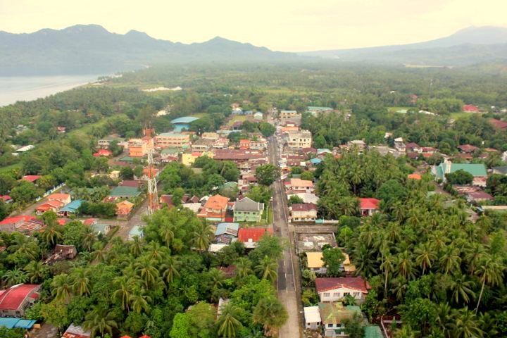 Aerial view of Hinunangan | |
 Flag  Seal | |
| Motto: Rice Granary of Southern Leyte | |
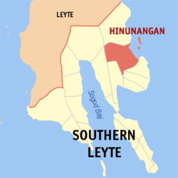 Map of Southern Leyte with Hinunangan highlighted | |
OpenStreetMap  | |
 Hinunangan Location within the Philippines | |
| Coordinates: 10°24′N 125°12′E | |
| Country | Philippines |
| Region | Eastern Visayas |
| Province | Southern Leyte |
| District | 2nd district |
| Barangays | 40 (see Barangays) |
| Government | |
| • Type | Sangguniang Bayan |
| • Mayor | Reynaldo C. Fernandez (PDPLBN) |
| • Vice Mayor | Marian D. Pelin (PDPLBN) |
| • Representative | Christopherson M. Yap |
| • Municipal Council | Members |
| • Electorate | 21,314 voters (2019) |
| Area | |
| • Total | 170.58 km2 (65.86 sq mi) |
| Elevation | 4.8 m (15.7 ft) |
| Highest elevation | 401 m (1,316 ft) |
| Lowest elevation | −1 m (−3 ft) |
| Population | |
| • Total | 29,149 |
| • Density | 170/km2 (440/sq mi) |
| • Households | 6,925 |
| Economy | |
| • Income class | 3rd municipal income class |
| • Poverty incidence | 25.21% (2018)[5] |
| • Revenue | ₱138,166,256.59 (2020) |
| • Assets | ₱253,993,689.45 (2020) |
| • Expenditure | ₱135,991,603.39 (2020) |
| • Liabilities | ₱97,005,813.88 (2020) |
| Service provider | |
| • Electricity | Southern Leyte Electric Cooperative (SOLECO) |
| Time zone | UTC+8 (PST) |
| ZIP code | 6608 |
| PSGC | |
| IDD : area code | +63 (0)53 |
| Native languages | Boholano dialect Cebuano Tagalog |
Hinunangan is known as the "Rice Granary of the Province" for its vast plain land that is entirely planted with rice. Hinunangan has great potential for tourism because of its beautiful sand beaches and islands. The town is also a producer of rattan and wood-based furnitures, abaca handicrafts items, pineapple, vegetables, other forest products, and bamboo furnitures. It has a potential for mineral water and root crops processing and copper mining.[6]
Hinunangan is also known as a major gateway in Leyte because of its near proximity to Tacloban City. The opening of Abuyog–Silago Road cuts travel time from Tacloban by half from the previous 6 hours to less than 3 hours. It is also the place in Southern Leyte with the most immigrants from Europe and North America.
It has a lot of touristic places, such as Tahusan, Talisay or the twin islands (known as Cabugan Grande and Cabugan Chico as Pigafetta stated in his account during their travel with Magellan).[citation needed]. There are also hotels, inns, a public market and beach resorts.
History
In 1521, Magellan recorded sighting Hunonganan (Hinunangan) during the voyage in Leyte Gulf. As far back in 1750, Hinunangan was a mid-way station of Boholanos trading in Eastern Leyte. They rested overnight at the mouth of Das-ay River where they moored their boats. A shelter was built for the crews and tenders known as "hononganan" or stopover. Hence the name. In 1822, a certain Boholano named Palonoy founded Hinunangan.[7] At this time, Silago to the north and Hinundayan and Anahawan to the south were part of Hinunangan.
In 1944, in the greatest naval battle in history the blocking warship of the Liberation waylaid the Japanese Fleet near Hinunangan. Thus, the area in Southern Leyte is the natural frontier of historically significant events in Philippine history.
2007 earthquake
On July 19, 2007, a strong earthquake hit the town with magnitude 6 on Richter scale and damaged some properties. The partial assessment report of Hinunangan dated July 20, a copy of which was obtained by PIA through Gov. Mercado, placed the estimated cost of damage to properties at P1,650,000.00 broken down as P790,000 for government infrastructure and P860,000 from private infrastructure.[8]
Among the public properties destroyed were the water system - P 500,000; Das-ay Bridge railguard - P100,000; East Central School Concrete Fence - P80,000; Otama Elementary School - P50,000; Patong Elementary School - P40,000; and Tahusan Elementary School—P20,000.[8]
The private infrastructure damaged included the Roman Catholic Bell tower - P100,000; Water tank of the Catholic convent - P40,000; Manalog barangay Chapel - P20,000; Santo Nino barangay Chapel - P10,000; a number of houses - P400,000, and various appliances, P290,000.
Geography
Hinunangan is home to the highest mountain in the province, Mount Nacolod, with an elevation of 948 metres (3,110 ft) above sea level.[9]
Barangays
Hinunangan is politically subdivided into 40 barangays, two of which are island barangays located at the east of the town. The twin islands are accessible by motorized boats through Barangay Canipa-an.
| Barangay | Population (2007) |
Population (2010) |
Population (2015) |
Population (2020) |
|---|---|---|---|---|
| Ambacon | 637 | |||
| Badiangon | 647 | |||
| Bangcas A | 668 | |||
| Bangcas B | 903 | |||
| Biasong | 609 | |||
| Bugho | 961 | |||
| Calag-itan | 1,167 | |||
| Calayugan | 678 | |||
| Calinao | 317 | |||
| Canipaan | 1,425 | |||
| Catublian | 1,373 | |||
| Ilaya | 520 | |||
| Ingan | 923 | |||
| Labrador | 800 | |||
| Libas | 463 | |||
| Lumbog | 363 | |||
| Manalog | 700 | |||
| Manlico | 745 | |||
| Matin-ao | 506 | |||
| Nava | 1,798 | |||
| Nueva Esperanza | 651 | |||
| Otama | 543 | |||
| Palongpong | 405 | |||
| Panalaron | 588 | |||
| Patong | 706 | |||
| Poblacion | 799 | |||
| Pondol | 957 | |||
| Salog | 349 | |||
| Salvacion | 519 | |||
| San Pablo Island | 427 | |||
| San Pedro Island | 473 | |||
| Santo Niño I | 559 | |||
| Santo Niño II | 946 | |||
| Tahusan | 920 | |||
| Talisay | 553 | |||
| Tawog | 486 | |||
| Toptop | 434 | |||
| Tuburan | 600 | |||
| Union | 397 | |||
| Upper Bantawon | 197 |
Climate
| Climate data for Hinunangan, Southern Leyte | |||||||||||||
|---|---|---|---|---|---|---|---|---|---|---|---|---|---|
| Month | Jan | Feb | Mar | Apr | May | Jun | Jul | Aug | Sep | Oct | Nov | Dec | Year |
| Average high °C (°F) | 28 (82) |
29 (84) |
29 (84) |
30 (86) |
30 (86) |
30 (86) |
29 (84) |
29 (84) |
29 (84) |
29 (84) |
29 (84) |
29 (84) |
29 (84) |
| Average low °C (°F) | 22 (72) |
22 (72) |
22 (72) |
23 (73) |
25 (77) |
25 (77) |
25 (77) |
25 (77) |
25 (77) |
24 (75) |
24 (75) |
23 (73) |
24 (75) |
| Average precipitation mm (inches) | 78 (3.1) |
57 (2.2) |
84 (3.3) |
79 (3.1) |
118 (4.6) |
181 (7.1) |
178 (7.0) |
169 (6.7) |
172 (6.8) |
180 (7.1) |
174 (6.9) |
128 (5.0) |
1,598 (62.9) |
| Average rainy days | 16.7 | 13.8 | 17.3 | 18.5 | 23.2 | 26.5 | 27.1 | 26.0 | 26.4 | 27.5 | 24.6 | 21.0 | 268.6 |
| Source: Meteoblue[10] | |||||||||||||
Demographics
| Year | Pop. | ±% p.a. |
|---|---|---|
| 1903 | 8,574 | — |
| 1918 | 11,491 | +1.97% |
| 1939 | 16,983 | +1.88% |
| 1948 | 17,556 | +0.37% |
| 1960 | 12,665 | −2.68% |
| 1970 | 16,142 | +2.45% |
| 1975 | 18,648 | +2.94% |
| 1980 | 20,568 | +1.98% |
| 1990 | 22,454 | +0.88% |
| 1995 | 22,170 | −0.24% |
| 2000 | 25,016 | +2.62% |
| 2007 | 27,712 | +1.42% |
| 2010 | 28,415 | +0.92% |
| 2015 | 29,976 | +1.02% |
| 2020 | 29,149 | −0.55% |
| Source: Philippine Statistics Authority [11] [12] [13][14] | ||
Economy
Banking and Finance
- Philippine National Bank[22]
- Saints Peter & Paul Multi-Purpose Cooperative
- Leyte South Multi-Purpose Cooperative
Education
Primary schools
- Hinunangan East Central School
- Hinunangan West Central School
- Catublian Elementary School
- Nava Elementary School
- Canipaan Elementary School
- Ambacon Elementary School
- Calag-itan Elementary School
- Pondol Elementary School
- Manalog Elementary School
- Patong Elementary School
- Otama Elementary School
- Ingan Elementary School
Secondary schools
- Holy Rosary Academy - a Private Roman Catholic school
- Hinunangan National High School - formerly Hinunangan Agricultural and Vocational School
- Canipaan National High School
- Nava National High School
Tertiary Schools
- Southern Leyte State University - Hinunangan Campus (formerly Southern Leyte Institute of Agriculture and Technology)
Others
- Hinunangan Skills and Technological Center[23] - TESDA accredited vocational school.
Healthcare
- Zenon T. Lagumbay Memorial Hospital
- Hinunangan Community Hospital
Media
- Hinunangnon - crowdsourcing social news network in Hinunangan, founded in 2016 that brings digital news and top stories locally from Hinunangan and its Province or around the world.[24][25]
- 92.1 MHz FM - Spin FM Hinunangan (Defunct)
- 90.8 MHz FM - Mix FM Hinunangan[26]
- 105.0 MHz FM - Best FM Hinunangan[27]
Communication
Mobile:
- Smart Communications (Since 2002)[28]
- Globe Telecom (Since 2004)
- Sun Cellular (Since 2012)
Cable television:
- Fiesta Cable TV
- Direct-To-Home (DTH) satellite TV Service provider
Internet:
- Wireless Internet through SMART Network (Smart Bro's 3G/HSPA/HSPA+)
- Wireless Internet through Globe Network (Globe Tattoo)
Gallery
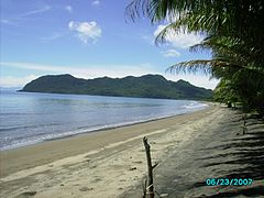 View of Hinunangan Bay from Poblacion
 San Pablo and San Pedro Islands off the coast of Hinunangn. The town's major tourist attraction.
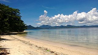 White beach at San Pablo Island, Hinunangan


References
- Municipality of Hinunangan | (DILG)
- "2015 Census of Population, Report No. 3 – Population, Land Area, and Population Density" (PDF). Philippine Statistics Authority. Quezon City, Philippines. August 2016. ISSN 0117-1453. Archived (PDF) from the original on May 25, 2021. Retrieved July 16, 2021.
- https://www.philatlas.com/visayas/r08/southern-leyte/hinunangan.html.
- Census of Population (2020). "Region VIII (Eastern Visayas)". Total Population by Province, City, Municipality and Barangay. PSA. Retrieved 8 July 2021.
- "PSA Releases the 2018 Municipal and City Level Poverty Estimates". Philippine Statistics Authority. 15 December 2021. Retrieved 22 January 2022.
- "Local Government Unit". Archived from the original on 2006-05-21. Retrieved 2008-11-05., Southern Leyte LGU website
- Hinunangan History, Hinunangan.net
- Hinunangan MDCC bares earthquake partial damage assessment report, Philippine Information Agency
- Archived 2008-11-18 at the Wayback Machine, NSCB Southern Leyte Profile
- "Hinunangan, Southern Leyte : Average Temperatures and Rainfall". Meteoblue. Retrieved 6 January 2019.
- Census of Population (2015). "Region VIII (Eastern Visayas)". Total Population by Province, City, Municipality and Barangay. PSA. Retrieved 20 June 2016.
- Census of Population and Housing (2010). "Region VIII (Eastern Visayas)". Total Population by Province, City, Municipality and Barangay. NSO. Retrieved 29 June 2016.
- Censuses of Population (1903–2007). "Region VIII (Eastern Visayas)". Table 1. Population Enumerated in Various Censuses by Province/Highly Urbanized City: 1903 to 2007. NSO.
- "Province of Southern Leyte". Municipality Population Data. Local Water Utilities Administration Research Division. Retrieved 17 December 2016.
- "Poverty incidence (PI):". Philippine Statistics Authority. Retrieved 28 December 2020.
- https://psa.gov.ph/sites/default/files/NSCB_LocalPovertyPhilippines_0.pdf; publication date: 29 November 2005; publisher: Philippine Statistics Authority.
- https://psa.gov.ph/sites/default/files/2003%20SAE%20of%20poverty%20%28Full%20Report%29_1.pdf; publication date: 23 March 2009; publisher: Philippine Statistics Authority.
- https://psa.gov.ph/sites/default/files/2006%20and%202009%20City%20and%20Municipal%20Level%20Poverty%20Estimates_0_1.pdf; publication date: 3 August 2012; publisher: Philippine Statistics Authority.
- https://psa.gov.ph/sites/default/files/2012%20Municipal%20and%20City%20Level%20Poverty%20Estima7tes%20Publication%20%281%29.pdf; publication date: 31 May 2016; publisher: Philippine Statistics Authority.
- https://psa.gov.ph/sites/default/files/City%20and%20Municipal-level%20Small%20Area%20Poverty%20Estimates_%202009%2C%202012%20and%202015_0.xlsx; publication date: 10 July 2019; publisher: Philippine Statistics Authority.
- "PSA Releases the 2018 Municipal and City Level Poverty Estimates". Philippine Statistics Authority. 15 December 2021. Retrieved 22 January 2022.
- PNB_Domestic_Branch_Directory
- TESDA Hinunangan Skills and Technological Center [permanent dead link]
- Hinunangnon Facebook Page
- "| Hinunangnon Official Website". Archived from the original on 2018-03-23. Retrieved 2018-05-04.
- 90.8 Mix FM
- 105.0 Best FM
- Smart increases coverage in remote, rural areas
External links
- Hinunangan Profile at PhilAtlas.com
- Philippine Standard Geographic Code
- Philippine Census Information
- Local Governance Performance Management System
- Travels through Hinunangan
Places adjacent to Hinunangan | ||||||||||||||||
|---|---|---|---|---|---|---|---|---|---|---|---|---|---|---|---|---|
| ||||||||||||||||
Maasin (capital) | |
| Municipalities | |
| Component City | |
На других языках
[de] Hinunangan
Hinunangan ist eine philippinische Stadtgemeinde in der Provinz Southern Leyte auf der Insel Leyte. Sie hat 29.976 Einwohner (Zensus 1. August 2015), die in 40 Barangays leben. Die Gemeinde wird als teilweise urban beschrieben. Hinunangan liegt ca. 144 km östlich der Provinzhauptstadt Maasin City und ist von dort über den Maharlika Highway via der Gemeinde Sogod erreichbar. Die beiden der Küste vorgelagerten Inseln San Pedro und San Pablo gehören zum Verwaltungsgebiet der Gemeinde.- [en] Hinunangan
Другой контент может иметь иную лицензию. Перед использованием материалов сайта WikiSort.org внимательно изучите правила лицензирования конкретных элементов наполнения сайта.
WikiSort.org - проект по пересортировке и дополнению контента Википедии