world.wikisort.org - Philippines
Valencia, officially the Municipality of Valencia, is a 1st class municipality in the province of Negros Oriental, Philippines. According to the 2020 census, it has a population of 38,733 people. [3]
Valencia
Luzurriaga | |
|---|---|
Municipality | |
| Municipality of Valencia | |
 Geothermal power station in Barangay Puhagan | |
 Seal | |
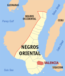 Map of Negros Oriental with Valencia highlighted | |
OpenStreetMap  | |
 Valencia Location within the Philippines | |
| Coordinates: 9°17′N 123°15′E | |
| Country | Philippines |
| Region | Central Visayas |
| Province | Negros Oriental |
| District | 3rd district |
| Barangays | 24 (see Barangays) |
| Government | |
| • Type | Sangguniang Bayan |
| • Mayor | Edgar Z. Teves Jr. (NPC) |
| • Vice Mayor | Romeo T. Alviola (NPC) |
| • Representative | Arnolfo A. Teves Jr. |
| • Municipal Council | Members |
| • Electorate | 25,882 voters (2019) |
| Area | |
| • Total | 147.49 km2 (56.95 sq mi) |
| Elevation | 275 m (902 ft) |
| Highest elevation | 1,276 m (4,186 ft) |
| Lowest elevation | 21 m (69 ft) |
| Population | |
| • Total | 38,733 |
| • Density | 260/km2 (680/sq mi) |
| • Households | 7,965 |
| Economy | |
| • Income class | 1st municipal income class |
| • Poverty incidence | 13.00% (2018)[4] |
| • Revenue | ₱222,082,888.30 (2020) |
| • Assets | ₱1,279,066,206.23 (2020) |
| • Expenditure | ₱237,601,706.74 (2020) |
| • Liabilities | ₱517,282,464.46 (2020) |
| Service provider | |
| • Electricity | Negros Oriental 2 Electric Cooperative (NORECO 2) |
| Time zone | UTC+8 (PST) |
| ZIP code | 6215 |
| PSGC | |
| IDD : area code | +63 (0)35 |
| Native languages | Cebuano Tagalog |
| Named after | Valencia, Spain |
It is located 10 kilometres (6.2 mi) west of Dumaguete City, the most populated city and capital of the province. The municipality was voted as "the greenest and cleanest" town of Negros Oriental in 2007.[5]
Our Lady of the Abandoned is the patroness of Valencia, and her feast day is celebrated annually every October 12 with the town fiesta. The fiesta is an official non-working holiday for the town.
History
Valencia was originally named Ermita, which means "a secluded place", due to its being a refuge from marauding Muslim pirates. In 1856, it was renamed Nueva Valencia by Spanish colonizers, in honor of its parish priest Father Matias Villamayor from Valencia, Spain. He also had a fountain brought over from his aforementioned hometown, which currently sits in front of the Town Hall.
In 1920, it was renamed Luzurriaga (often times misspelt as Luzuriaga) in honour of Don Carlos Ruíz de Luzurriaga, a delegate from Negros island to the Philippine Legislature who promised town officials he would work hard to help improve the town. The town reverted to Valencia in 1948, by virtue of Republic Act 252.[6]
During World War II, Malabo was the headquarters of the Free Government and resistance movement in Negros Oriental.[7]: 127–135
In 2007, its Municipal Police Station which is under the Negros Oriental Provincial Police Office (NOPPO) headed by Senior Superintendent Melvin Ramon Buenafe) was adjudged the “Municipal Police Station of 2007” in the best unit awards category, and the best town police station in the Central Visayas (General order number 110 dated January 22, 2008).[8]
Geography
Valencia occupies an area of 14,749 hectares (36,450 acres), 35% of which are classified as plains. The town is 65% mountainous, with elevation averaging from 200 to 500 metres (660 to 1,640 ft) above sea level, with the top of Mount Talinis at an elevation of 1,903 metres (6,243 ft) along the municipal southern boundary. The climate in the municipality is relatively cool, especially at higher elevations.
The region is also the most critical watershed area of Negros Oriental, providing abundant drinking water to Valencia and its neighboring municipalities.
Barangays
The town is politically subdivided into 24 barangays.
- Apolong
- East Balabag
- West Balabag
- Balayagmanok
- Balili
- Balugo
- Bongbong
- Bong-ao
- Calayugan
- Cambucad
- Dobdob
- Jawa
- Caidiocan
- Liptong
- Lunga
- Malabo
- Malaunay
- Mampas
- Palinpinon
- North Poblacion
- South Poblacion
- Puhagan
- Pulangbato
- Sagbang
Climate
| Climate data for Valencia, Negros Oriental | |||||||||||||
|---|---|---|---|---|---|---|---|---|---|---|---|---|---|
| Month | Jan | Feb | Mar | Apr | May | Jun | Jul | Aug | Sep | Oct | Nov | Dec | Year |
| Average high °C (°F) | 28 (82) |
29 (84) |
30 (86) |
31 (88) |
30 (86) |
29 (84) |
29 (84) |
29 (84) |
29 (84) |
28 (82) |
28 (82) |
28 (82) |
29 (84) |
| Average low °C (°F) | 21 (70) |
21 (70) |
21 (70) |
22 (72) |
23 (73) |
23 (73) |
23 (73) |
23 (73) |
23 (73) |
23 (73) |
22 (72) |
21 (70) |
22 (72) |
| Average precipitation mm (inches) | 26 (1.0) |
22 (0.9) |
28 (1.1) |
41 (1.6) |
95 (3.7) |
136 (5.4) |
147 (5.8) |
126 (5.0) |
132 (5.2) |
150 (5.9) |
98 (3.9) |
46 (1.8) |
1,047 (41.3) |
| Average rainy days | 7.5 | 6.7 | 8.9 | 10.4 | 21.6 | 25.6 | 26.3 | 25.0 | 24.1 | 26.2 | 19.2 | 12.1 | 213.6 |
| Source: Meteoblue (Use with caution: this is modeled/calculated data, not measured locally.)[9] | |||||||||||||
Demographics
| Year | Pop. | ±% p.a. |
|---|---|---|
| 1903 | 8,726 | — |
| 1918 | 8,825 | +0.08% |
| 1939 | 9,979 | +0.59% |
| 1948 | 7,059 | −3.77% |
| 1960 | 10,048 | +2.99% |
| 1970 | 13,318 | +2.85% |
| 1975 | 14,656 | +1.94% |
| 1980 | 14,645 | −0.02% |
| 1990 | 18,102 | +2.14% |
| 1995 | 20,147 | +2.03% |
| 2000 | 24,365 | +4.16% |
| 2007 | 27,933 | +1.90% |
| 2010 | 31,477 | +4.44% |
| 2015 | 34,852 | +1.96% |
| 2020 | 38,733 | +2.10% |
| Source: Philippine Statistics Authority [10] [11] [12][13] | ||
The Cebuano language is the common vernacular in Valencia. Hiligaynon, Tagalog, and English are also widely spoken.
Economy


The economy of Valencia is largely based on agriculture. Major products include abaca, copra, corn, flowers, vegetables, root crops, and exotic fruits such as lanzones and rambutan.
The municipality is also the site of a geothermal power station operated by the Energy Development Corporation. It generates electricity that supplies the needs of Negros, Panay, and parts of Cebu. The municipal government receives royalties from the power station.
Valencia, specifically, has a 20-megawatt Palinpinon 2 Geothermal Optimization Project in Sitio Nasuji, Barangay Puhagan, 35 kilometers from Dumaguete City. The P 1.74-billion geothermal optimization (expansion) project, funded the Development Bank of the Philippines (DBP) is part of EDC's 192-MW Southern Negros Geothermal Production Field that supplies the power needs of 8 provinces in Negros, Panay, Guimaras and Cebu Islands. Valencia's 192-MW Palinpinon I and II geothermal field ranks 4th in installed capacity nationwide. The Palinpinon field contributed $457.8 million in 2004 foreign exchange savings for 2004, and also generated $267 million savings from January to July, 2008.
Because Palinpinon is such a big source of geothermal energy, Gloria Macapagal Arroyo said it received P 250 million in royalties, applied for livelihood, education, related projects, and also for the 50% subsidy on Valencia electric bills consumers.[21] Many residents also work in the nearby city of Dumaguete.
Tourism
The Filipino-Japanese Amity Memorial Shrine is located in Valencia. It stands at the foot of Mount Talinis and marks the spot where the combined Filipino and American troops including the Negrosanon guerrilla units fought the Japanese Imperial Army toward the end of World War II.


Eco-tourism sites include:
- Tejero Highland Resort and Adventure Park - is the newest attraction in Central Philippines to offer the best value-for-your-money relaxation and recreation facility. It features a speed dual zipline, ATVs, segway, Aquazorb, slide, natural pools, restaurant and hotel. Located only 3 kilometers from town proper of Valencia, Tejero is the nearest natural attraction from Dumaguete, and considered the most popular of tourist destinations.
- Casaroro Waterfalls - as the province's most photographed body of water, it is relatively enclosed by lush greenery and natural rock formations. The falls' cool water gushes down to a swimming hole.
- The Forest Camp Resort - was first opened in 1990, as a 6,000 square meter property, today its 2.2 hectares of land is a vast camping ground, with 2 large nipa hut houses, 4 cottages, a tree house, a 250-people capacity conference/reception hall, a backpacker's den and a dormitory that can hold up to 20 students.
- The Spanish Fountain - a relic of the town's colorful historical past at the heart of the municipal plaza, has a unique sunken design, and was once the town's major source of water supply (invented by an Augustinian Recollect Friars to channel water from an upland spring).
- Cata-al War Memorabilia - a private collection by an 84-year-old World War II survivor Porforio Cata-al, at his residence cum museum. It includes bombs, grenades, Japanese and American bills, coins, medals, charred pieces of an authentic military uniform, and a Japanese soldier mummy
- Filipino-American-Japanese Amity Shrine - on a hilltop of Sagbang, this is a 3-sided pillar representing the 3 countries (Philippines, America and Japan), unveiled in 1977.
- Banica Swimming Lagoon - known as Tejeros resort, it has 2 man made pools fed by Banica River.
- Malabo/Pulangbato Falls - is a swimming and diving hole with many reddish rocks.
- Red Rock Hot Spring - dipping pool
- Mount Talinis - a 1,903-meter peak in the Cuernos de Negros which has a number of volcanic lakes and extensive biodiversity.
- Balinsasayao Twin Lakes Natural Park - a protected area near Mount Talinis surrounding two crater lakes.
Education
Public High Schools[22]
| School Name | Location |
|---|---|
| Pulangbato National High School | Pulangbato |
| Balugo National High School | Balugo |
| Valencia National High School (formerly Valencia Technical School) | Bong-ao |
| Valencia National High School -Dobdob Extension | Dobdob |
Public Elementary Schools[22]
- Badiang Primary School
- Balabag Elementary School
- Balili Primary School
- Balugo Elementary School
- Bong-ao Elementary School
- Bongbong Elementary School
- Caidiocan Elementary School
- Dobdob Elementary School
- Dungga Primary School
- Inas Primary School
- Liptong Elementary School
- Malabo Primary School
- Malaunay Elementary School
- Nasuji Primary School
- Palinpinon Elementary School
- Puhagan Elementary School
- Pulangbato Elementary School
- Sagbang Elementary School
- Valencia Central Elementary School
- Vicente I. Villa Memorial School
Government
List of former chief executives
- Mariano Imbo (Captain)
- Gerardo Imbo (1916 - 1919)
- Eustaquio Vincoy (1919 - 1927)
- Guillermo Albina (1928 - 1931)
- Quiterio Mariño (1931 - 1939)
- Jose Villamil (1940 - 1946)
- Rodolfo Gonzalez, Senior (1946 - 1967)
- Elpidio Unto (1968 - 1971)
- Rodolfo Gonzalez, Senior (1972 - 1980)
- Saludario Sonjaco (1981 - 1986)
- Victor Naces (1986 - 1987)
- Jose Villamil (Officer in Charge) (1987 - 1988)
- Edgar Teves (1988 - 1998)
- Humberto Sy (1998 - 2001)
- Rodolfo Gonzalez, Junior (2001 – 2010)
- Enrique Gonzalez (2010 - 2013)
- Edgar Teves (2013–present)
References
- Municipality of Valencia | (DILG)
- "2015 Census of Population, Report No. 3 – Population, Land Area, and Population Density" (PDF). Philippine Statistics Authority. Quezon City, Philippines. August 2016. ISSN 0117-1453. Archived (PDF) from the original on May 25, 2021. Retrieved July 16, 2021.
- Census of Population (2020). "Region VII (Central Visayas)". Total Population by Province, City, Municipality and Barangay. PSA. Retrieved 8 July 2021.
- "PSA Releases the 2018 Municipal and City Level Poverty Estimates". Philippine Statistics Authority. 15 December 2021. Retrieved 22 January 2022.
- elgu.ncc.gov.ph, The Greenest and Cleanest Town of Negros Oriental
- "An act to change the name of the municipality of Luzurriaga, province of Negros Oriental, to that of "Valencia"". LawPH.com. Retrieved 2011-04-08.
- Mills, S.A., 2009, Stranded in the Philippines, Annapolis: Naval Institute Press, ISBN 9781591144977
- globalnation.inquirer.net, Valencia police station in NegOr adjudged best
- "Valencia: Average Temperatures and Rainfall". Meteoblue. Retrieved 6 May 2020.
- Census of Population (2015). "Region VII (Central Visayas)". Total Population by Province, City, Municipality and Barangay. PSA. Retrieved 20 June 2016.
- Census of Population and Housing (2010). "Region VII (Central Visayas)". Total Population by Province, City, Municipality and Barangay. NSO. Retrieved 29 June 2016.
- Censuses of Population (1903–2007). "Region VII (Central Visayas)". Table 1. Population Enumerated in Various Censuses by Province/Highly Urbanized City: 1903 to 2007. NSO.
- "Province of". Municipality Population Data. Local Water Utilities Administration Research Division. Retrieved 17 December 2016.
- "Poverty incidence (PI):". Philippine Statistics Authority. Retrieved 28 December 2020.
- https://psa.gov.ph/sites/default/files/NSCB_LocalPovertyPhilippines_0.pdf; publication date: 29 November 2005; publisher: Philippine Statistics Authority.
- https://psa.gov.ph/sites/default/files/2003%20SAE%20of%20poverty%20%28Full%20Report%29_1.pdf; publication date: 23 March 2009; publisher: Philippine Statistics Authority.
- https://psa.gov.ph/sites/default/files/2006%20and%202009%20City%20and%20Municipal%20Level%20Poverty%20Estimates_0_1.pdf; publication date: 3 August 2012; publisher: Philippine Statistics Authority.
- https://psa.gov.ph/sites/default/files/2012%20Municipal%20and%20City%20Level%20Poverty%20Estima7tes%20Publication%20%281%29.pdf; publication date: 31 May 2016; publisher: Philippine Statistics Authority.
- https://psa.gov.ph/sites/default/files/City%20and%20Municipal-level%20Small%20Area%20Poverty%20Estimates_%202009%2C%202012%20and%202015_0.xlsx; publication date: 10 July 2019; publisher: Philippine Statistics Authority.
- "PSA Releases the 2018 Municipal and City Level Poverty Estimates". Philippine Statistics Authority. 15 December 2021. Retrieved 22 January 2022.
- pia.gov.ph, PGMA invites industries to invest in Negros Oriental and enjoy 50% power subsidy
- "dumaguete.com". Retrieved Sep 30, 2014.
External links
- The travel guide Wikivoyage includes Valencia in its Dumaguete article.
- Philippine Standard Geographic Code
- Philippine Census Information
- Local Governance Performance Management System
Dumaguete (capital) | |
| Municipalities | |
| Component cities | |
На других языках
[de] Valencia (Negros Oriental)
Valencia (Luzurriaga) ist eine philippinische Gemeinde in der Provinz Negros Oriental. Sie hat 34.852 Einwohner (Zensus 1. August 2015).- [en] Valencia, Negros Oriental
Другой контент может иметь иную лицензию. Перед использованием материалов сайта WikiSort.org внимательно изучите правила лицензирования конкретных элементов наполнения сайта.
WikiSort.org - проект по пересортировке и дополнению контента Википедии