world.wikisort.org - Japan
Obira (小平町, Obira-chō) is a town located in Rumoi Subprefecture, Hokkaido, Japan.
This article needs additional citations for verification. (March 2022) |
This article may be expanded with text translated from the corresponding article in Japanese. (September 2022) Click [show] for important translation instructions.
|
Obira
小平町 | |
|---|---|
Town | |
 Flag  Seal | |
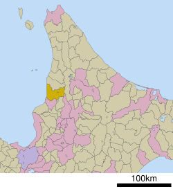 Location of Obira in Hokkaido (Rumoi Subprefecture) | |
 Obira Location in Japan | |
| Coordinates: 44°1′N 141°40′E | |
| Country | Japan |
| Region | Hokkaido |
| Prefecture | Hokkaido (Rumoi Subprefecture) |
| District | Rumoi |
| Area | |
| • Total | 627.29 km2 (242.20 sq mi) |
| Population (30 September 2016) | |
| • Total | 3,277 |
| • Density | 5.2/km2 (14/sq mi) |
| Time zone | UTC+09:00 (JST) |
| Climate | Dfb |
| Website | www |
As of September 2016, the town has an estimated population of 3,277 and a density of 5.2 persons per km2. The total area is 627.29 km2.
Climate
| Climate data for Tappu, Obira (1991−2020 normals, extremes 1977−present) | |||||||||||||
|---|---|---|---|---|---|---|---|---|---|---|---|---|---|
| Month | Jan | Feb | Mar | Apr | May | Jun | Jul | Aug | Sep | Oct | Nov | Dec | Year |
| Record high °C (°F) | 7.4 (45.3) |
10.3 (50.5) |
15.5 (59.9) |
25.4 (77.7) |
32.5 (90.5) |
34.3 (93.7) |
36.5 (97.7) |
38.7 (101.7) |
32.1 (89.8) |
24.9 (76.8) |
20.9 (69.6) |
11.4 (52.5) |
38.7 (101.7) |
| Average high °C (°F) | −2.0 (28.4) |
−1.1 (30.0) |
3.1 (37.6) |
9.7 (49.5) |
17.3 (63.1) |
21.8 (71.2) |
25.5 (77.9) |
26.0 (78.8) |
22.0 (71.6) |
15.1 (59.2) |
6.6 (43.9) |
−0.1 (31.8) |
12.0 (53.6) |
| Daily mean °C (°F) | −6.4 (20.5) |
−5.9 (21.4) |
−1.6 (29.1) |
4.2 (39.6) |
11.0 (51.8) |
15.8 (60.4) |
19.9 (67.8) |
20.5 (68.9) |
15.9 (60.6) |
9.2 (48.6) |
2.7 (36.9) |
−3.5 (25.7) |
6.8 (44.3) |
| Average low °C (°F) | −11.8 (10.8) |
−12.0 (10.4) |
−7.1 (19.2) |
−1.1 (30.0) |
4.6 (40.3) |
10.5 (50.9) |
15.2 (59.4) |
16.0 (60.8) |
10.6 (51.1) |
4.1 (39.4) |
−1.0 (30.2) |
−7.3 (18.9) |
1.7 (35.1) |
| Record low °C (°F) | −29.7 (−21.5) |
−30.0 (−22.0) |
−25.0 (−13.0) |
−14.2 (6.4) |
−4.1 (24.6) |
−0.6 (30.9) |
4.9 (40.8) |
5.3 (41.5) |
0.1 (32.2) |
−5.2 (22.6) |
−15.4 (4.3) |
−28.6 (−19.5) |
−30.0 (−22.0) |
| Average precipitation mm (inches) | 155.2 (6.11) |
106.7 (4.20) |
90.9 (3.58) |
74.2 (2.92) |
88.0 (3.46) |
73.9 (2.91) |
148.1 (5.83) |
167.8 (6.61) |
172.0 (6.77) |
178.5 (7.03) |
202.9 (7.99) |
198.9 (7.83) |
1,653.6 (65.10) |
| Average rainy days | 22.6 | 18.9 | 17.6 | 12.6 | 12.2 | 10.6 | 11.7 | 13.0 | 14.7 | 17.7 | 21.5 | 25.2 | 198.3 |
| Mean monthly sunshine hours | 40.5 | 57.7 | 107.6 | 159.1 | 195.9 | 171.5 | 162.3 | 159.3 | 156.0 | 114.4 | 44.6 | 26.8 | 1,399.4 |
| Source 1: JMA[1] | |||||||||||||
| Source 2: JMA[2] | |||||||||||||
Mascot

Obira's mascot is Obimaru (おびまる) who is a curious and kind heart superhero that resembles a bull. Legend has it that this figure was formed from a bull, a melon, an octopus, two scallops, two fishes and a rice bowl on August 12, 2014. No one knows its gender yet. It can eat anything that is locally produced especially melon, beef, octopus, scallops, herring and rice. His charm point is a red star on his forehead to show its status has mascot of the town.[3]
References
- 観測史上1~10位の値(年間を通じての値). JMA. Retrieved 21 February 2022.
- 気象庁 / 平年値(年・月ごとの値). JMA. Retrieved 21 February 2022.
- "小平町PRキャラクター「おびまる」". Obira.
External links
 Media related to Obira, Hokkaidō at Wikimedia Commons
- Official Website (in Japanese)
Sapporo (capital) | ||||||||||||
| ||||||||||||
| ||||||||||||
| ||||||||||||
| ||||||||||||
| ||||||||||||
| ||||||||||||
| ||||||||||||
| ||||||||||||
| ||||||||||||
| ||||||||||||
| ||||||||||||
| ||||||||||||
| ||||||||||||
| ||||||||||||
List of mergers in Hokkaido | ||||||||||||
This Hokkaidō location article is a stub. You can help Wikipedia by expanding it. |
На других языках
[de] Obira (Hokkaidō)
Obira (jap. .mw-parser-output .Hani{font-size:110%}小平町, -chō) ist eine Kleinstadt im Landkreis Rumoi in der Unterpräfektur Rumoi auf Hokkaidō.- [en] Obira, Hokkaido
[ru] Обира
Обира (яп. 小平町 Обира-тё:) — посёлок в Японии, находящийся в уезде Румои округа Румои губернаторства Хоккайдо. Площадь посёлка составляет 627,29 км²[1], население — 3422 человека (30 июня 2014)[2], плотность населения — 5,46 чел./км².Другой контент может иметь иную лицензию. Перед использованием материалов сайта WikiSort.org внимательно изучите правила лицензирования конкретных элементов наполнения сайта.
WikiSort.org - проект по пересортировке и дополнению контента Википедии