world.wikisort.org - Philippines
Mabitac, officially the Municipality of Mabitac (Tagalog: Bayan ng Mabitac), is a 5th class municipality in the province of Laguna, Philippines. According to the 2020 census, it has a population of 21,275 people. [3]
Mabitac | |
|---|---|
Municipality | |
| Municipality of Mabitac | |
 Hilltop view of Mabitac | |
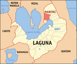 Map of Laguna with Mabitac highlighted | |
OpenStreetMap  | |
 Mabitac Location within the Philippines | |
| Coordinates: 14°26′N 121°25′E | |
| Country | Philippines |
| Region | Calabarzon |
| Province | Laguna |
| District | 4th district |
| Founded | January 6, 1616 |
| Barangays | 15 (see Barangays) |
| Government | |
| • Type | Sangguniang Bayan |
| • Mayor | Alberto S. Reyes |
| • Vice Mayor | Ronald I. Sana |
| • Representative | Maria Jamina Katherine B. Agarao |
| • Municipal Council | Members |
| • Electorate | 14,602 voters (2019) |
| Area | |
| • Total | 80.76 km2 (31.18 sq mi) |
| Elevation | 128 m (420 ft) |
| Highest elevation | 726 m (2,382 ft) |
| Lowest elevation | −1 m (−3 ft) |
| Population | |
| • Total | 21,275 |
| • Density | 260/km2 (680/sq mi) |
| • Households | 4,490 |
| Economy | |
| • Income class | 5th municipal income class |
| • Poverty incidence | 2.99% (2018)[4] |
| • Revenue | ₱105,947,358.73 (2020) |
| • Assets | ₱140,913,695.89 (2020) |
| • Expenditure | ₱93,758,199.48 (2020) |
| • Liabilities | ₱41,273,493.95 (2020) |
| Service provider | |
| • Electricity | First Laguna Electric Cooperative (FLECO) |
| Time zone | UTC+8 (PST) |
| ZIP code | 4020 |
| PSGC | |
| IDD : area code | +63 (0)49 |
| Native languages | Tagalog |
| Website | www |
Mabitac was an excellent hunting ground for wild game three centuries ago. Native hunters used numerous cave-ins or trap-ins called "bitag" in the local dialect. Hence, the place was referred to as "Mabitag" meaning "a place with many traps".
Mabitac is situated on the eastern side of the province of Laguna, 88 kilometres (55 mi) from Manila using Rizal Province on a winding road of Manila East Road, and Antipolo City or 123 kilometres (76 mi) via the South Luzon Express, Calamba and Santa Cruz, Laguna.
History
The first Spaniards who came to this place were the friars who established the first Spanish settlement in the area and began to Christianize the local population. The Spaniards, having difficulty in pronouncing the "G" consonant, called this place "Mabitac" whenever they mentioned this place. Eventually, the name found its way in the official records and maps of Laguna made by Spanish cartographers and mariners who chartered the coastal areas of Laguna de Bay.
This town was formerly a barrio of Siniloan, an immediate neighboring town. It became an independent municipality only in the year 1611, not by legislation, but by mutual agreement by and between the Spanish friars of both towns who were then the influential ruling class.
Mabitac was the site of a battle in the Philippine–American War, when on September 17, 1900, Filipinos under General Juan Cailles defeated an American force commanded by Colonel Benjamin F. Cheatham.
World War II and Japanese occupation

The Japanese occupation of the Philippines occurred between 1942 and 1945, when Imperial Japan occupied the Commonwealth of the Philippines during World War II. The invasion of the Philippines started on 8 December 1941, ten hours after the attack on Pearl Harbor.
In 1942, Japanese soldiers entered and occupied Mabitac. In 1945, the Philippine Commonwealth Army troops of the 4th, 42nd and 43rd Infantry Division and 4th Constabulary Regiment of the Philippine Constabulary together with the recognized guerrillas defeated the Japanese Imperial forces during the Second Battle of Mabitac.
Geography
Barangays
Mabitac is politically subdivided into 15 barangays: [5]
- Amuyong
- Lambac (Poblacion)
- Lucong (Poblacion)
- Matalatala
- Nanguma
- Numero
- Paagahan
- Bayanihan (Poblacion)
- Libis ng Nayon (Poblacion)
- Maligaya (Poblacion)
- Masikap (Poblacion)
- Pag-Asa (Poblacion)
- Sinagtala (Poblacion)
- San Antonio
- San Miguel
Climate
| Climate data for Mabitac, Laguna | |||||||||||||
|---|---|---|---|---|---|---|---|---|---|---|---|---|---|
| Month | Jan | Feb | Mar | Apr | May | Jun | Jul | Aug | Sep | Oct | Nov | Dec | Year |
| Average high °C (°F) | 26 (79) |
27 (81) |
29 (84) |
31 (88) |
31 (88) |
30 (86) |
29 (84) |
29 (84) |
29 (84) |
29 (84) |
28 (82) |
26 (79) |
29 (84) |
| Average low °C (°F) | 22 (72) |
22 (72) |
22 (72) |
23 (73) |
24 (75) |
25 (77) |
24 (75) |
24 (75) |
24 (75) |
24 (75) |
24 (75) |
23 (73) |
23 (74) |
| Average precipitation mm (inches) | 58 (2.3) |
41 (1.6) |
32 (1.3) |
29 (1.1) |
91 (3.6) |
143 (5.6) |
181 (7.1) |
162 (6.4) |
172 (6.8) |
164 (6.5) |
113 (4.4) |
121 (4.8) |
1,307 (51.5) |
| Average rainy days | 13.4 | 9.3 | 9.1 | 9.8 | 19.1 | 22.9 | 26.6 | 24.9 | 25.0 | 21.4 | 16.5 | 16.5 | 214.5 |
| Source: Meteoblue[6] | |||||||||||||
Demographics
| Year | Pop. | ±% p.a. |
|---|---|---|
| 1903 | 1,052 | — |
| 1918 | 760 | −2.14% |
| 1939 | 1,973 | +4.65% |
| 1948 | 2,700 | +3.55% |
| 1960 | 4,316 | +3.99% |
| 1970 | 6,377 | +3.98% |
| 1975 | 7,415 | +3.07% |
| 1980 | 8,543 | +2.87% |
| 1990 | 11,444 | +2.97% |
| 1995 | 13,309 | +2.87% |
| 2000 | 15,097 | +2.74% |
| 2007 | 17,608 | +2.14% |
| 2010 | 18,618 | +2.05% |
| 2015 | 20,530 | +1.88% |
| 2020 | 21,275 | +0.70% |
| Source: Philippine Statistics Authority [7] [8] [9][10] | ||
In the 2020 census, the population of Mabitac was 21,275 people, [3] with a density of 260 inhabitants per square kilometre or 670 inhabitants per square mile.
Economy
Gallery
 Welcome marker
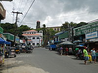 Poblacion
 Town hall
 Nuestra Señora de Candelaria Parish Church


Notable personalities
- Juan Cailles (born Juan Cailles y Kauppama; November 10, 1871 – June 28, 1951) was a Filipino of French-Indian descent. A member of the revolutionary movement Katipunan, he was a commanding officer of the Philippine Revolutionary Army who served during the Philippine Revolution and Philippine–American War. He later served as a provincial Governor of Laguna and a member of the Philippine Legislature.
See also
- Battle of Mabitac
References
- Municipality of Mabitac | (DILG)
- "2015 Census of Population, Report No. 3 – Population, Land Area, and Population Density" (PDF). Philippine Statistics Authority. Quezon City, Philippines. August 2016. ISSN 0117-1453. Archived (PDF) from the original on May 25, 2021. Retrieved July 16, 2021.
- Census of Population (2020). "Region IV-A (Calabarzon)". Total Population by Province, City, Municipality and Barangay. PSA. Retrieved 8 July 2021.
- "PSA Releases the 2018 Municipal and City Level Poverty Estimates". Philippine Statistics Authority. 15 December 2021. Retrieved 22 January 2022.
- "Province: Laguna". PSGC Interactive. Quezon City, Philippines: Philippine Statistics Authority. Retrieved 12 November 2016.
- "Mabitac: Average Temperatures and Rainfall". Meteoblue. Retrieved 11 May 2020.
- Census of Population (2015). "Region IV-A (Calabarzon)". Total Population by Province, City, Municipality and Barangay. PSA. Retrieved 20 June 2016.
- Census of Population and Housing (2010). "Region IV-A (Calabarzon)". Total Population by Province, City, Municipality and Barangay. NSO. Retrieved 29 June 2016.
- Censuses of Population (1903–2007). "Region IV-A (Calabarzon)". Table 1. Population Enumerated in Various Censuses by Province/Highly Urbanized City: 1903 to 2007. NSO.
- "Province of Laguna". Municipality Population Data. Local Water Utilities Administration Research Division. Retrieved 17 December 2016.
- "Poverty incidence (PI):". Philippine Statistics Authority. Retrieved 28 December 2020.
- https://psa.gov.ph/sites/default/files/NSCB_LocalPovertyPhilippines_0.pdf; publication date: 29 November 2005; publisher: Philippine Statistics Authority.
- https://psa.gov.ph/sites/default/files/2003%20SAE%20of%20poverty%20%28Full%20Report%29_1.pdf; publication date: 23 March 2009; publisher: Philippine Statistics Authority.
- https://psa.gov.ph/sites/default/files/2006%20and%202009%20City%20and%20Municipal%20Level%20Poverty%20Estimates_0_1.pdf; publication date: 3 August 2012; publisher: Philippine Statistics Authority.
- https://psa.gov.ph/sites/default/files/2012%20Municipal%20and%20City%20Level%20Poverty%20Estima7tes%20Publication%20%281%29.pdf; publication date: 31 May 2016; publisher: Philippine Statistics Authority.
- https://psa.gov.ph/sites/default/files/City%20and%20Municipal-level%20Small%20Area%20Poverty%20Estimates_%202009%2C%202012%20and%202015_0.xlsx; publication date: 10 July 2019; publisher: Philippine Statistics Authority.
- "PSA Releases the 2018 Municipal and City Level Poverty Estimates". Philippine Statistics Authority. 15 December 2021. Retrieved 22 January 2022.
External links
- "Municipality of Mabitac", Province of Laguna Website
- Philippine Standard Geographic Code
- Philippine Census Information
- Local Governance Performance Management System
Places adjacent to Mabitac | ||||||||||||||||
|---|---|---|---|---|---|---|---|---|---|---|---|---|---|---|---|---|
| ||||||||||||||||

На других языках
[de] Mabitac
Mabitac ist eine philippinische Stadtgemeinde in der Provinz Laguna, in der Verwaltungsregion IV, Calabarzon. Sie hat 20.530 Einwohner (Zensus 1. August 2015), die in 15 Barangays lebten. Sie wird als Gemeinde der fünften Einkommensklasse auf den Philippinen und als teilweise urbanisiert eingestuft.- [en] Mabitac
Другой контент может иметь иную лицензию. Перед использованием материалов сайта WikiSort.org внимательно изучите правила лицензирования конкретных элементов наполнения сайта.
WikiSort.org - проект по пересортировке и дополнению контента Википедии