world.wikisort.org - Philippines
Santa Teresita, officially the Municipality of Santa Teresita (Tagalog: Bayan ng Santa Teresita), is a 5th class municipality in the province of Batangas, Philippines. According to the 2020 census, it has a population of 21,559 people. [5]
Santa Teresita | |
|---|---|
Municipality | |
| Municipality of Santa Teresita | |
 Street in Santa Teresita | |
 Seal | |
 Map of Batangas with Santa Teresita highlighted | |
OpenStreetMap  | |
 Santa Teresita Location within the Philippines | |
| Coordinates: 13°51′59″N 120°58′53″E | |
| Country | Philippines |
| Region | Calabarzon |
| Province | Batangas |
| District | 3rd district |
| Founded | December 28, 1961[1] |
| Named for | St. Therese of the Child Jesus[2] |
| Barangays | 17 (see Barangays) |
| Government | |
| • Type | Sangguniang Bayan |
| • Mayor | Norberto A. Segunial, Jr. |
| • Vice Mayor | Maria Aurea V. Segunial |
| • Representative | Ma. Theresa V. Collantes |
| • Municipal Council | Members |
| • Electorate | 13,637 voters (2019) |
| Area | |
| • Total | 16.30 km2 (6.29 sq mi) |
| Elevation | 83 m (272 ft) |
| Highest elevation | 234 m (768 ft) |
| Lowest elevation | 5 m (16 ft) |
| Population | |
| • Total | 21,559 |
| • Density | 1,300/km2 (3,400/sq mi) |
| • Households | 4,218 |
| Economy | |
| • Income class | 5th municipal income class |
| • Poverty incidence | 10.75% (2018)[6] |
| • Revenue | ₱97,189,166.12 (2020) |
| • Assets | ₱260,714,999.13 (2020) |
| • Expenditure | ₱76,899,300.87 (2020) |
| • Liabilities | ₱50,325,683.90 (2020) |
| Service provider | |
| • Electricity | Batangas 1 Electric Cooperative (BATELEC 1) |
| Time zone | UTC+8 (PST) |
| ZIP code | 4206 |
| PSGC | |
| IDD : area code | +63 (0)43 |
| Native languages | Tagalog |
History
On December 28, 1961, the barrios of Sambat, Sinipian, Bihis, Calayaan, Irukan and Cutang Cawayan from the municipality of Taal, Calumala, Tambo, Saimsim and Burol from the municipality of San Nicolas, and Pacifico and Sampa from the municipality of San Luis were separated and constituted into a new and separate municipality known as Santa Teresita, by virtue of Executive Order No. 454 signed by President Carlos P. Garcia.[1] The new municipality was named after its patron saint, St. Therese of the Child Jesus. Ireneo Aquino was appointed as its first mayor, serving until June 1962. In 1971, barangay Antipolo was established as a separate barangay out of barangay Sinipian, as well as barangay Cuta East, which was separated from barangay Cutang Cawayan.[7]
Geography
Santa Teresita is located at 13°51′59″N 120°58′53″E along the southern lakeshore area of Taal Lake. Its boundaries are San Nicolas in the north, San Luis on the south, Taal on the west and Taal Lake on the northeast.
According to the Philippine Statistics Authority, the municipality has a land area of 16.30 square kilometres (6.29 sq mi) [8] constituting 0.52% of the 3,119.75-square-kilometre- (1,204.54 sq mi) total area of Batangas.
Santa Teresita 17 kilometres (11 mi) from Batangas City and 122 kilometres (76 mi) from Manila.
Barangays
Santa Teresita is politically subdivided into 17 barangays, with 3 classified as urban and 14 as rural[9]
| PSGC | Barangay | Population | ±% p.a. | |||
|---|---|---|---|---|---|---|
| 2020 [5] | 2010 [10] | |||||
| 041027001 | Antipolo | 3.6% | 768 | 696 | 0.95% | |
| 041027002 | Bihis | 7.3% | 1,584 | 1,373 | 1.38% | |
| 041027003 | Burol | 3.1% | 667 | 454 | 3.75% | |
| 041027004 | Calayaan | 9.6% | 2,060 | 1,902 | 0.77% | |
| 041027005 | Calumala | 6.2% | 1,346 | 1,289 | 0.42% | |
| 041027006 | Cuta East | 5.5% | 1,185 | 991 | 1.73% | |
| 041027007 | Cutang Cawayan | 3.4% | 733 | 510 | 3.54% | |
| 041027008 | Irukan | 3.0% | 637 | 598 | 0.61% | |
| 041027009 | Pacifico | 9.0% | 1,945 | 1,680 | 1.41% | |
| 041027010 | Poblacion I | 7.7% | 1,662 | 1,483 | 1.10% | |
| 041027012 | Saimsim | 12.7% | 2,730 | 1,910 | 3.48% | |
| 041027013 | Sampa | 6.0% | 1,295 | 1,172 | 0.96% | |
| 041027014 | Sinipian | 4.2% | 898 | 705 | 2.35% | |
| 041027015 | Tambo Ibaba | 4.5% | 976 | 683 | 3.48% | |
| 041027016 | Tambo Ilaya | 4.3% | 920 | 580 | 4.52% | |
| 041027017 | Poblacion II | 5.5% | 1,180 | 986 | 1.74% | |
| 041027018 | Poblacion III | 2.5% | 541 | 403 | 2.86% | |
| Total | 21,559 | 17,415 | 2.07% | |||
Climate
| Climate data for Santa Teresita, Batangas | |||||||||||||
|---|---|---|---|---|---|---|---|---|---|---|---|---|---|
| Month | Jan | Feb | Mar | Apr | May | Jun | Jul | Aug | Sep | Oct | Nov | Dec | Year |
| Average high °C (°F) | 28 (82) |
29 (84) |
30 (86) |
32 (90) |
31 (88) |
29 (84) |
28 (82) |
28 (82) |
28 (82) |
28 (82) |
28 (82) |
28 (82) |
29 (84) |
| Average low °C (°F) | 19 (66) |
19 (66) |
20 (68) |
21 (70) |
23 (73) |
23 (73) |
23 (73) |
23 (73) |
23 (73) |
22 (72) |
21 (70) |
20 (68) |
21 (70) |
| Average precipitation mm (inches) | 11 (0.4) |
13 (0.5) |
14 (0.6) |
32 (1.3) |
101 (4.0) |
142 (5.6) |
208 (8.2) |
187 (7.4) |
175 (6.9) |
131 (5.2) |
68 (2.7) |
39 (1.5) |
1,121 (44.3) |
| Average rainy days | 5.2 | 5.0 | 7.4 | 11.5 | 19.8 | 23.5 | 27.0 | 25.9 | 25.2 | 23.2 | 15.5 | 8.3 | 197.5 |
| Source: Meteoblue[11] | |||||||||||||
Demographics
| Year | Pop. | ±% p.a. |
|---|---|---|
| 1970 | 9,336 | — |
| 1975 | 10,087 | +1.56% |
| 1980 | 11,134 | +1.99% |
| 1990 | 12,005 | +0.76% |
| 1995 | 14,017 | +2.95% |
| 2000 | 14,074 | +0.09% |
| 2007 | 16,891 | +2.55% |
| 2010 | 17,415 | +1.12% |
| 2015 | 21,127 | +3.75% |
| 2020 | 21,559 | +0.40% |
| Source: Philippine Statistics Authority [12] [10] [13][14] | ||
In the 2020 census, Santa Teresita had a population of 21,559. [5] The population density was 1,300 inhabitants per square kilometre (3,400/sq mi).
Economy
Gallery
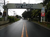 Welcome arch
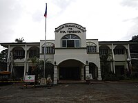 Old municipal hall
 Downtown
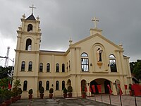 Archdiocesan Shrine of Saint Therese of the Child Jesus and of the Holy Face


References
- Exec. Order No. 454, s. 1961 (December 28, 1961) Official Gazette of the Republic of the Philippines
- "Sta. Teresita". Department of the Interior and Local Government Region IV-A CALABARZON. Retrieved August 30, 2020.
- Municipality of Santa Teresita | (DILG)
- "2015 Census of Population, Report No. 3 – Population, Land Area, and Population Density" (PDF). Philippine Statistics Authority. Quezon City, Philippines. August 2016. ISSN 0117-1453. Archived (PDF) from the original on May 25, 2021. Retrieved July 16, 2021.
- Census of Population (2020). "Region IV-A (Calabarzon)". Total Population by Province, City, Municipality and Barangay. PSA. Retrieved 8 July 2021.
- "PSA Releases the 2018 Municipal and City Level Poverty Estimates". Philippine Statistics Authority. 15 December 2021. Retrieved 22 January 2022.
- "History". Municipality of Sta. Teresita. Retrieved January 21, 2022.
- "Province: Batangas". PSGC Interactive. Quezon City, Philippines: Philippine Statistics Authority. Retrieved 12 November 2016.
- "Municipal: Santa Teresita, Batangas". PSGC Interactive. Quezon City, Philippines: Philippine Statistics Authority. Retrieved 8 January 2016.
- Census of Population and Housing (2010). "Region IV-A (Calabarzon)". Total Population by Province, City, Municipality and Barangay. NSO. Retrieved 29 June 2016.
- "Santa Teresita: Average Temperatures and Rainfall". Meteoblue. Retrieved 5 May 2020.
- Census of Population (2015). "Region IV-A (Calabarzon)". Total Population by Province, City, Municipality and Barangay. PSA. Retrieved 20 June 2016.
- Censuses of Population (1903–2007). "Region IV-A (Calabarzon)". Table 1. Population Enumerated in Various Censuses by Province/Highly Urbanized City: 1903 to 2007. NSO.
- "Province of Batangas". Municipality Population Data. Local Water Utilities Administration Research Division. Retrieved 17 December 2016.
- "Poverty incidence (PI):". Philippine Statistics Authority. Retrieved 28 December 2020.
- https://psa.gov.ph/sites/default/files/NSCB_LocalPovertyPhilippines_0.pdf; publication date: 29 November 2005; publisher: Philippine Statistics Authority.
- https://psa.gov.ph/sites/default/files/2003%20SAE%20of%20poverty%20%28Full%20Report%29_1.pdf; publication date: 23 March 2009; publisher: Philippine Statistics Authority.
- https://psa.gov.ph/sites/default/files/2006%20and%202009%20City%20and%20Municipal%20Level%20Poverty%20Estimates_0_1.pdf; publication date: 3 August 2012; publisher: Philippine Statistics Authority.
- https://psa.gov.ph/sites/default/files/2012%20Municipal%20and%20City%20Level%20Poverty%20Estima7tes%20Publication%20%281%29.pdf; publication date: 31 May 2016; publisher: Philippine Statistics Authority.
- https://psa.gov.ph/sites/default/files/City%20and%20Municipal-level%20Small%20Area%20Poverty%20Estimates_%202009%2C%202012%20and%202015_0.xlsx; publication date: 10 July 2019; publisher: Philippine Statistics Authority.
- "PSA Releases the 2018 Municipal and City Level Poverty Estimates". Philippine Statistics Authority. 15 December 2021. Retrieved 22 January 2022.
External links
Places adjacent to Santa Teresita, Batangas | ||||||||||||||||
|---|---|---|---|---|---|---|---|---|---|---|---|---|---|---|---|---|
| ||||||||||||||||
Batangas City (capital) | |
| Component cities | |
| Municipalities | |
This article about a location in Calabarzon region is a stub. You can help Wikipedia by expanding it. |
На других языках
[de] Santa Teresita (Batangas)
Santa Teresita ist eine philippinische Stadtgemeinde in der Provinz Batangas. Sie hat 21.127 Einwohner (Zensus 1. August 2015).- [en] Santa Teresita, Batangas
Другой контент может иметь иную лицензию. Перед использованием материалов сайта WikiSort.org внимательно изучите правила лицензирования конкретных элементов наполнения сайта.
WikiSort.org - проект по пересортировке и дополнению контента Википедии