world.wikisort.org - Philippines
Talisay, officially the Municipality of Talisay (Tagalog: Bayan ng Talisay), is a 3rd class municipality in the province of Batangas, Philippines. According to the 2020 census, it has a population of 46,238 people. [3]
Talisay | |
|---|---|
Municipality | |
| Municipality of Talisay | |
 Street in Talisay | |
 Seal | |
| Nickname: Seedling Bowl of Batangas | |
| Anthem: Talisay Hymn | |
 Map of Batangas with Talisay highlighted | |
OpenStreetMap  | |
 Talisay Location within the Philippines | |
| Coordinates: 14°06′N 121°01′E | |
| Country | Philippines |
| Region | Calabarzon |
| Province | Batangas |
| District | 3rd district |
| Founded | February 10, 1869 |
| Barangays | 21 (see Barangays) |
| Government | |
| • Type | Sangguniang Bayan |
| • Mayor | Nestor D. Natanauan |
| • Vice Mayor | Francis M. Magsino |
| • Representative | Ma. Theresa V. Collantes |
| • Municipal Council | Members |
| • Electorate | 28,134 voters (2019) |
| Area | |
| • Total | 28.20 km2 (10.89 sq mi) |
| Elevation | 227 m (745 ft) |
| Highest elevation | 743 m (2,438 ft) |
| Lowest elevation | 5 m (16 ft) |
| Population | |
| • Total | 46,238 |
| • Density | 1,600/km2 (4,200/sq mi) |
| • Households | 9,685 |
| Economy | |
| • Income class | 3rd municipal income class |
| • Poverty incidence | 10.72% (2018)[4] |
| • Revenue | ₱178,775,625.11 (2020) |
| • Assets | ₱663,274,257.05 (2020) |
| • Expenditure | ₱141,817,879.60 (2020) |
| • Liabilities | ₱276,191,094.23 (2020) |
| Service provider | |
| • Electricity | Batangas 2 Electric Cooperative (BATELEC 2) |
| Time zone | UTC+8 (PST) |
| ZIP code | 4220 |
| PSGC | |
| IDD : area code | IDD : area code |
| Native languages | Tagalog |
| Website | www |
Geography
Talisay is located at 14°06′N 121°01′E, in the north-central area of Batangas which is located south-west of the island of Luzon. Talisay is 56 kilometres (35 mi) from Batangas City and 79 kilometres (49 mi) south from Metro Manila. It is bordered in the north by Tagaytay, west by Laurel, east by Tanauan, and south by a vast volcanic lake called Taal Lake.
According to the Philippine Statistics Authority, the municipality has a land area of 28.20 square kilometres (10.89 sq mi) [5] constituting 0.90% of the 3,119.75-square-kilometre- (1,204.54 sq mi) total area of Batangas.
Barangays
Talisay is politically subdivided into 21 barangays.[6] In 1953, the sitio of Buco in the barrio of Balas was converted into a barangay.[7]
| PSGC | Barangay | Population | ±% p.a. | |||
|---|---|---|---|---|---|---|
| 2020 [3] | 2010 [8] | |||||
| 041030001 | Aya | 13.4% | 6,215 | 5,523 | 1.14% | |
| 041030003 | Balas | 3.3% | 1,530 | 1,187 | 2.46% | |
| 041030004 | Banga | 8.8% | 4,050 | 3,917 | 0.32% | |
| 041030006 | Buco | 2.2% | 1,005 | 975 | 0.29% | |
| 041030008 | Caloocan | 3.9% | 1,785 | 1,665 | 0.67% | |
| 041030009 | Leynes | 3.2% | 1,473 | 1,387 | 0.58% | |
| 041030010 | Miranda | 4.1% | 1,902 | 1,413 | 2.88% | |
| 041030011 | Poblacion Barangay 1 | 4.2% | 1,921 | 1,781 | 0.73% | |
| 041030012 | Poblacion Barangay 2 | 3.0% | 1,381 | 1,361 | 0.14% | |
| 041030013 | Poblacion Barangay 3 | 1.6% | 728 | 781 | −0.67% | |
| 041030014 | Poblacion Barangay 4 | 2.0% | 928 | 799 | 1.44% | |
| 041030015 | Poblacion Barangay 5 | 0.6% | 265 | 221 | 1.75% | |
| 041030016 | Poblacion Barangay 6 | 8.2% | 3,796 | 2,428 | 4.37% | |
| 041030017 | Poblacion Barangay 7 | 1.1% | 504 | 483 | 0.41% | |
| 041030018 | Poblacion Barangay 8 | 1.6% | 736 | 770 | −0.43% | |
| 041030019 | Quiling | 9.8% | 4,544 | 3,855 | 1.59% | |
| 041030020 | Sampaloc | 9.8% | 4,531 | 3,960 | 1.30% | |
| 041030021 | San Guillermo | 2.3% | 1,066 | 991 | 0.70% | |
| 041030023 | Santa Maria | 3.0% | 1,387 | 1,357 | 0.21% | |
| 041030024 | Tranca | 6.4% | 2,950 | 2,660 | 1.00% | |
| 041030025 | Tumaway | 5.6% | 2,604 | 2,086 | 2.15% | |
| Total | 46,238 | 39,600 | 1.49% | |||
Climate
| Climate data for Talisay, Batangas | |||||||||||||
|---|---|---|---|---|---|---|---|---|---|---|---|---|---|
| Month | Jan | Feb | Mar | Apr | May | Jun | Jul | Aug | Sep | Oct | Nov | Dec | Year |
| Average high °C (°F) | 29 (84) |
30 (86) |
31 (88) |
33 (91) |
32 (90) |
30 (86) |
29 (84) |
29 (84) |
29 (84) |
29 (84) |
29 (84) |
29 (84) |
30 (86) |
| Average low °C (°F) | 20 (68) |
20 (68) |
21 (70) |
22 (72) |
24 (75) |
24 (75) |
24 (75) |
24 (75) |
24 (75) |
23 (73) |
22 (72) |
21 (70) |
22 (72) |
| Average precipitation mm (inches) | 11 (0.4) |
13 (0.5) |
14 (0.6) |
32 (1.3) |
101 (4.0) |
142 (5.6) |
208 (8.2) |
187 (7.4) |
175 (6.9) |
131 (5.2) |
68 (2.7) |
39 (1.5) |
1,121 (44.3) |
| Average rainy days | 5.2 | 5.0 | 7.4 | 11.5 | 19.8 | 23.5 | 27.0 | 25.9 | 25.2 | 23.2 | 15.5 | 8.3 | 197.5 |
| Source: Meteoblue[9] | |||||||||||||
Demographics
| Year | Pop. | ±% p.a. |
|---|---|---|
| 1903 | 5,657 | — |
| 1918 | 6,986 | +1.42% |
| 1939 | 11,939 | +2.58% |
| 1948 | 12,140 | +0.19% |
| 1960 | 19,834 | +4.17% |
| 1970 | 14,821 | −2.87% |
| 1975 | 16,624 | +2.33% |
| 1980 | 19,447 | +3.19% |
| 1990 | 23,153 | +1.76% |
| 1995 | 26,997 | +2.92% |
| 2000 | 32,465 | +4.03% |
| 2007 | 39,120 | +2.61% |
| 2010 | 39,600 | +0.44% |
| 2015 | 45,301 | +2.59% |
| 2020 | 46,238 | +0.40% |
| Source: Philippine Statistics Authority [10] [8] [11][12] | ||
In the 2020 census, Talisay had a population of 46,238. [3] The population density was 1,600 inhabitants per square kilometre (4,100/sq mi).
Educational Institutions
A. Primary
- Jorge B. Vargas Memorial Elementary School
- Mcrew Educational Institute
- Caloocan Elementary School
- Santo Agustino Academy
- Balas Elementary School
- Banga Elementary School
- Venancio Trinidad Sr. Memorial Elementary School
- Quiling Elementary School
- Dona Maria Laurel Platon Memorial School.
B. Secondary
- Balas Buco Sta. Maria National High School
- Talisay Polytechnic Institute
- Talisay High School
- San Guillermo Academy
- Talisay Senior High School
Economy
Government
- Mayor: Nestor D Natanauan
- Vice Mayor: Francis "Patet" Magsino
- Councilors
- Rolly C.Lamano
- Kap.Tess Panghulan
- Sk Pres.Nestor A. Cabrera
- Edgardo Caraan
- Henry De Leon
- Kap.Floring Mainot
- Melody L. Luna
- Felix "Bing" Salazar
Gallery
 Welcome arch
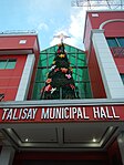 Municipal hall
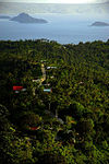 Aerial view
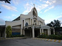 Saint William the Hermit Parish Church


References
- Municipality of Talisay | (DILG)
- "2015 Census of Population, Report No. 3 – Population, Land Area, and Population Density" (PDF). Philippine Statistics Authority. Quezon City, Philippines. August 2016. ISSN 0117-1453. Archived (PDF) from the original on May 25, 2021. Retrieved July 16, 2021.
- Census of Population (2020). "Region IV-A (Calabarzon)". Total Population by Province, City, Municipality and Barangay. PSA. Retrieved 8 July 2021.
- "PSA Releases the 2018 Municipal and City Level Poverty Estimates". Philippine Statistics Authority. 15 December 2021. Retrieved 22 January 2022.
- "Province: Batangas". PSGC Interactive. Quezon City, Philippines: Philippine Statistics Authority. Retrieved 12 November 2016.
- "Municipal: Talisay, Batangas". PSGC Interactive. Quezon City, Philippines: Philippine Statistics Authority. Retrieved 8 January 2016.
- "An Act to Convert the Sitio of Buco in the Barrio of Balas, Municipality of Talisay, Province of Batangas, into a Barrio". LawPH.com. Retrieved 2011-04-09.
- Census of Population and Housing (2010). "Region IV-A (Calabarzon)". Total Population by Province, City, Municipality and Barangay. NSO. Retrieved 29 June 2016.
- "Talisay: Average Temperatures and Rainfall". Meteoblue. Retrieved 5 May 2020.
- Census of Population (2015). "Region IV-A (Calabarzon)". Total Population by Province, City, Municipality and Barangay. PSA. Retrieved 20 June 2016.
- Censuses of Population (1903–2007). "Region IV-A (Calabarzon)". Table 1. Population Enumerated in Various Censuses by Province/Highly Urbanized City: 1903 to 2007. NSO.
- "Province of Batangas". Municipality Population Data. Local Water Utilities Administration Research Division. Retrieved 17 December 2016.
- "Poverty incidence (PI):". Philippine Statistics Authority. Retrieved 28 December 2020.
- https://psa.gov.ph/sites/default/files/NSCB_LocalPovertyPhilippines_0.pdf; publication date: 29 November 2005; publisher: Philippine Statistics Authority.
- https://psa.gov.ph/sites/default/files/2003%20SAE%20of%20poverty%20%28Full%20Report%29_1.pdf; publication date: 23 March 2009; publisher: Philippine Statistics Authority.
- https://psa.gov.ph/sites/default/files/2006%20and%202009%20City%20and%20Municipal%20Level%20Poverty%20Estimates_0_1.pdf; publication date: 3 August 2012; publisher: Philippine Statistics Authority.
- https://psa.gov.ph/sites/default/files/2012%20Municipal%20and%20City%20Level%20Poverty%20Estima7tes%20Publication%20%281%29.pdf; publication date: 31 May 2016; publisher: Philippine Statistics Authority.
- https://psa.gov.ph/sites/default/files/City%20and%20Municipal-level%20Small%20Area%20Poverty%20Estimates_%202009%2C%202012%20and%202015_0.xlsx; publication date: 10 July 2019; publisher: Philippine Statistics Authority.
- "PSA Releases the 2018 Municipal and City Level Poverty Estimates". Philippine Statistics Authority. 15 December 2021. Retrieved 22 January 2022.
External links
![]() Media related to Talisay, Batangas at Wikimedia Commons
Media related to Talisay, Batangas at Wikimedia Commons
Places adjacent to Talisay, Batangas | ||||||||||||||||
|---|---|---|---|---|---|---|---|---|---|---|---|---|---|---|---|---|
| ||||||||||||||||
Batangas City (capital) | |
| Component cities | |
| Municipalities | |
На других языках
[de] Talisay (Batangas)
Talisay ist eine philippinische Stadtgemeinde in der Provinz Batangas.- [en] Talisay, Batangas
Другой контент может иметь иную лицензию. Перед использованием материалов сайта WikiSort.org внимательно изучите правила лицензирования конкретных элементов наполнения сайта.
WikiSort.org - проект по пересортировке и дополнению контента Википедии