world.wikisort.org - India
Narmada district is an administrative district in the state of Gujarat in India. The district headquarters are located at Rajpipla. The district is bounded by Vadodara and Chhota Udaipur districts in the north, by Nandurbar district of Maharashtra state in the east, by Surat and Tapi districts in the south and by Bharuch district in the west. The district occupies an area of 2,755 km² and has a population of 590,297 (as of 2011). It was 10.44% urban as of 2011.[1] As of 2011, it is the third least populous district of Gujarat (out of 33), after Dang and Porbandar.[2]
Narmada District | |
|---|---|
District of Gujarat | |
 Zarwani Waterfall | |
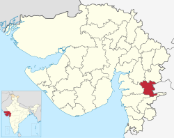 Location of district in Gujarat | |
| Coordinates: 21°52′14″N 73°30′10″E | |
| Country | |
| State | Gujarat |
| Area | |
| • Total | 2,755 km2 (1,064 sq mi) |
| Population (2011) | |
| • Total | 590,297 |
| • Density | 210/km2 (550/sq mi) |
| Languages | |
| • Official | Gujarati |
| Time zone | UTC+5:30 (IST) |
| Vehicle registration | GJ-22 |
| Website | narmada |
89.5% of the district's population is rural and 81.6% of the population is scheduled tribes.[3]
History
This district was carved out on October 2, 1997. The newly formed district consisted of Tilakwada taluka of erstwhile Vadodara district and 3 talukas of erstwhile Bharuch district: Nandod, Dediyapada and Sagbara.[4]
Administration
The district consists of 5 talukas: Tilakwada, Garudeshwar, Nandod (including Rajpipla), Dediyapada, and Sagbara.
It consists two Vidhan Sabha constituency: Nandod and Dediapada
Economy
In 2006 the Ministry of Panchayati Raj named Narmada one of the country's 250 most backward districts (out of a total of 640).[5] It is one of the six districts in Gujarat currently receiving funds from the Backward Regions Grant Fund Programme (BRGF).[5]
Demographics
According to the 2011 census Narmada district has a population of 590,297,[2] roughly equal to the nation of Solomon Islands[6] or the US state of Wyoming.[7] This gives it a ranking of 528th in India (out of a total of 640).[2] The district has a population density of 214 inhabitants per square kilometre (550/sq mi) .[2] Its population growth rate over the decade 2001-2011 was 14.77%.[2] Narmada has a sex ratio of 960 females for every 1000 males,[2] and a literacy rate of 73.29%. Scheduled Castes and Scheduled Tribes make up 1.48% and 81.55% of the population respectively.[2]
Language
At the time of the 2011 Census of India, 68.50% of the population in the district spoke Gujarati, 14.80% Vasava, 11.57% Haryanvi and 1.73% Hindi as their first language.[9]
Historical Population
| Year | Pop. | ±% p.a. |
|---|---|---|
| 1901 | 105,930 | — |
| 1911 | 121,901 | +1.41% |
| 1921 | 124,941 | +0.25% |
| 1931 | 142,172 | +1.30% |
| 1941 | 169,679 | +1.78% |
| 1951 | 188,765 | +1.07% |
| 1961 | 244,985 | +2.64% |
| 1971 | 312,095 | +2.45% |
| 1981 | 374,940 | +1.85% |
| 1991 | 449,376 | +1.83% |
| 2001 | 514,404 | +1.36% |
| 2011 | 590,297 | +1.39% |
| source:[10] | ||
Politics
| No. | Constituency | Name | Party | Remarks | |
|---|---|---|---|---|---|
| 148 | Nandod (ST) | Premsinhbhai Vasava | INC | ||
| 149 | Dediapada (ST) | Maheshbhai Vasava | BTP | ||
See also
- Shoolpaneshwar Wildlife Sanctuary
- Statue of Unity
- Narmada River
- Nandurbar district
References
- "Census GIS India". Archived from the original on 11 January 2010. Retrieved 20 November 2010.
- "Gujarat Distrct Census - Narmada" (PDF). Office of the Registrar General & Census Commissioner, India.
- "Narmada District Population, Caste, Religion Data (Gujarat) - Census 2011". Census India.
- "About District". Narmada District Panchayat.
- Ministry of Panchayati Raj (8 September 2009). "A Note on the Backward Regions Grant Fund Programme" (PDF). National Institute of Rural Development. Archived from the original (PDF) on 5 April 2012. Retrieved 27 September 2011.
- US Directorate of Intelligence. "Country Comparison:Population". Archived from the original on 13 June 2007. Retrieved 1 October 2011.
Solomon Islands 571,890 July 2011 est.
- "2010 Resident Population Data". U. S. Census Bureau. Retrieved 30 September 2011.
Wyoming 563,626
- "C-16 Population By Religion - Gujarat". census.gov.in. Office of the Registrar General & Census Commissioner, India.
- 2011 Census of India, Population By Mother Tongue
- Decadal Variation In Population Since 1901
External links
Places adjacent to Narmada district | ||||||||||||||||
|---|---|---|---|---|---|---|---|---|---|---|---|---|---|---|---|---|
| ||||||||||||||||
Capital: Gandhinagar | ||
| Topics |
|  |
| Regions of Gujarat |
| |
| Districts |
| |
| Major cities | ||
| Ecoregions |
| |
| Economy |
| |
| ||
Authority control | |
|---|---|
| General |
|
| National libraries | |
На других языках
[de] Narmada (Distrikt)
Der Distrikt Narmada (Gujarati: નર્મદા જીલ્લો) ist einer von 26 Distrikten des Staates Gujarat in Indien. Die Stadt Rajpipla ist die Hauptstadt des Distrikts. Die letzte Volkszählung im Jahr 2011 ergab eine Gesamtbevölkerungszahl von 590.297 Menschen.[1]- [en] Narmada district
[ru] Нармада (округ)
Нармада (гудж. નર્મદા જીલ્લો; англ. Narmada) — округ в индийском штате Гуджарат. Образован 2 октября 1997 года из частей территорий округов Бхаруч и Вадодара. Административный центр — город Раджпипла. Площадь округа — 2749 км². По данным всеиндийской переписи 2001 года население округа составляло 514 404 человека. Уровень грамотности взрослого населения составлял 59,86 %, что соответствовало среднеиндийскому уровню (59,5 %). Доля городского населения составляла 10,13 %.Другой контент может иметь иную лицензию. Перед использованием материалов сайта WikiSort.org внимательно изучите правила лицензирования конкретных элементов наполнения сайта.
WikiSort.org - проект по пересортировке и дополнению контента Википедии