world.wikisort.org - India
Patan district is one of the 33 districts of Gujarat state in western India. Its main city is Patan. This district is located in northern Gujarat and bounded by Banaskantha district in the north and northeast, Mehsana district in the east and southeast, Surendranagar district in the south and Kutch District and the Kutch nu Nanu Ran (Little Rann of Kutch) in the west. The district occupies an area of 5792 km².
This article uses bare URLs, which are uninformative and vulnerable to link rot. (August 2022) |
This article needs additional citations for verification. (August 2014) |
Patan district | |
|---|---|
district | |
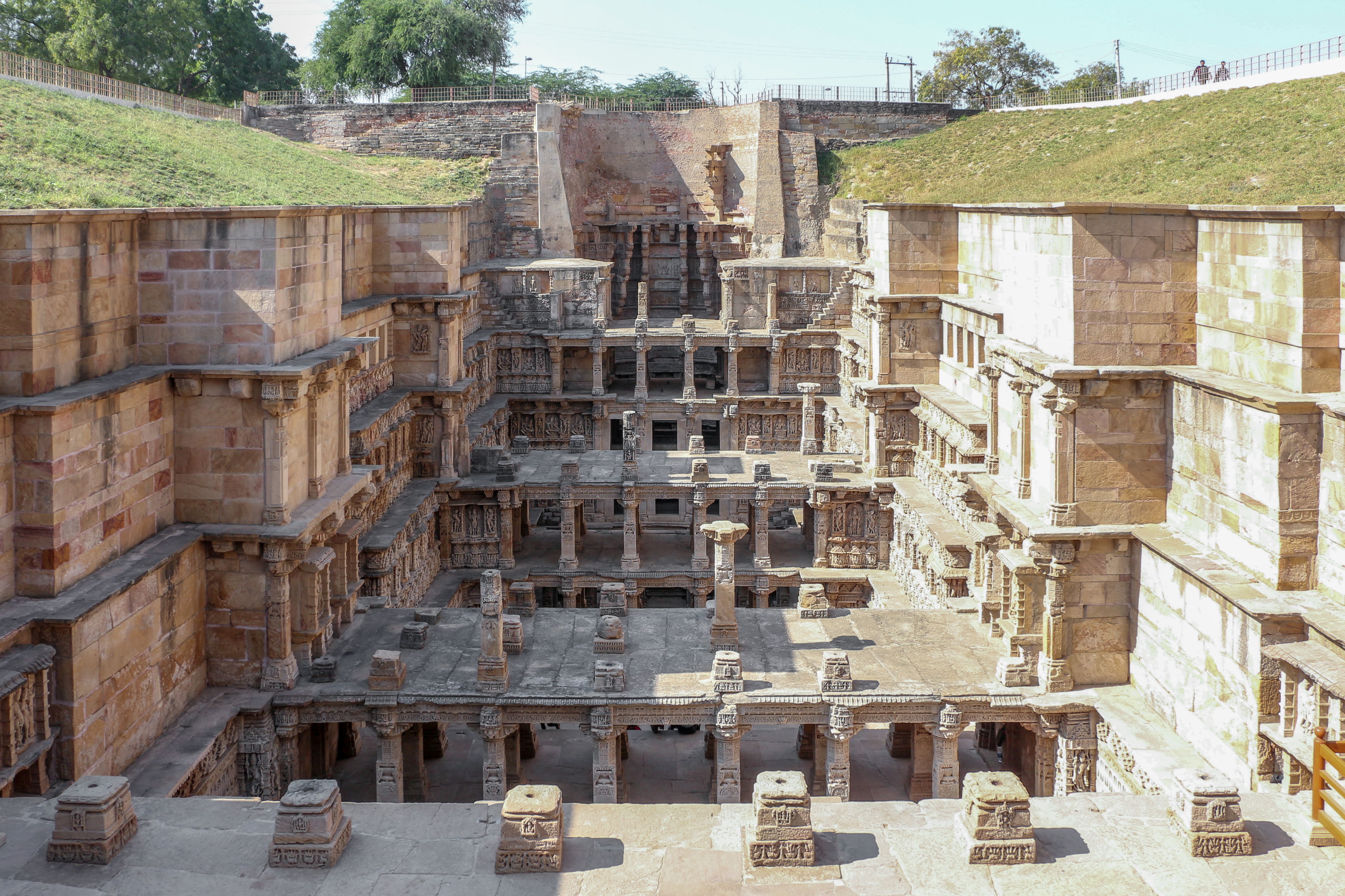 Rani ki vav in Patan | |
 Location of district in Gujarat | |
| Country | |
| State | Gujarat |
| Headquarters | Patan |
| Area | |
| • Total | 5,792 km2 (2,236 sq mi) |
| Population (2011) | |
| • Total | 1,343,734 |
| • Density | 230/km2 (600/sq mi) |
| Languages | |
| • Official | Gujarati, Hindi, English |
| Time zone | UTC+5:30 (IST) |
| Vehicle registration | GJ-24 |
| Website | gujaratindia |
Some of its areas, Harij and Sami, bordering Kutch are quite sensitive [citation needed] as there is no settled population between there and the border of Pakistan even though geographically the border is quite some distance away.
Origin of name
The district is named after Patan, the headquarters of the district. It was one of the ancient and early medieval capitals of Gujarat, described vividly in the novels written by [K.M. Munshi].Originally King [Vanraj Chavda] established this new city and named Anahilpur Patan OR Anhilvad Patan after the name of his very close friend Rabari chief anhil rabari. Anhil was known as a anabha in him rabari tribe. He was from ulva clan of Rabari. and the pioneer in establishing the state of Patan, the long fought battle against the then ruler from south with help of local tribals, citizens and loyal warriors to his father The king of state Panchasara few kilometers away from Patan today. Later, a number of rulers like Bhimdev, Kumarpal, Siddharaj and Karndev ruled from Patan.
History
Patan District was formed on 2-10-2000 from the parts of Mahesana and Banaskantha Districts. Patan District was formed including Patan, Siddhpur, Chanasma, Harij and Sami Talukas of Mahesana district and Radhanpur and Santalpur Talukas of Banaskantha District. The headquarter of the District is Patan. There are many Hindu temples and Jain Temple in the district.
Divisions
Patan district comprises nine Talukas:
Its headquarters is the city of Patan which, together with Modhera, is a significant tourist destination. Religious sites such as Shankheshwar Jain Temple are also popular, as is Sahastralinga Tank (a lake of thousand Lingas) and Rani ki vav (a deep well).[1]
Demographics
According to the 2011 census Patan district has a population of 1,343,734,[2] roughly equal to the nation of Eswatini.[3] This gives it a ranking of 359th in India (out of a total of 640). The district has a population density of 234 inhabitants per square kilometre (610/sq mi). Its population growth rate over the decade 2001-2011 was 13.53%. Patan has a sex ratio of 935 females for every 1000 males, and a literacy rate of 72.30%. Scheduled Castes and Scheduled Tribes make up 9.18% and 0.99% of the population respectively.[2]
At the time of the 2011 Census of India, 98.36% of the population in the district spoke Gujarati and 1.10% Hindi as their first language.[5]
Language
Politics
| No. | Constituency | Name | Party | Remarks | |
|---|---|---|---|---|---|
| 16 | Radhanpur | Alpesh Thakor | INC | Resigned from Congress in April 2019 and joined BJP | |
| Raghubhai Merajbhai Desai | INC | ||||
| 17 | Chanasma | Dilipkumar Thakor | BJP | ||
| 18 | Patan | Kiritkumar Patel | INC | ||
| 19 | Sidhpur | Chandanji Thakor | INC | ||
Solar project
Gujarat Solar Park at Charanka has a solar power production capacity of 750 Megawatt. The park, on the linesate, is being further developed.
References
- https://patandp.gujarat.gov.in
- "Gujarat Distrct Census - Patan" (PDF). Office of the Registrar General & Census Commissioner, India.
- US Directorate of Intelligence. "Country Comparison:Population". Archived from the original on June 13, 2007. Retrieved 2011-10-01.
Swaziland 1,370,424
- "C-16 Population By Religion - Gujarat". census.gov.in. Office of the Registrar General & Census Commissioner, India.
- 2011 Census of India, Population By Mother Tongue
External links
Places adjacent to Patan district | ||||||||||||||||
|---|---|---|---|---|---|---|---|---|---|---|---|---|---|---|---|---|
| ||||||||||||||||
Capital: Gandhinagar | ||
| Topics |
|  |
| Regions of Gujarat |
| |
| Districts |
| |
| Major cities | ||
| Ecoregions |
| |
| Economy |
| |
| ||
Authority control | |
|---|---|
| General |
|
| National libraries | |
На других языках
- [en] Patan district
[ru] Патан (округ)
Патан (гудж. પાટણ જિલ્લો; англ. Patan) — округ в индийском штате Гуджарат. Образован в 2000 году из частей территорий округов Мехсана и Банаскантха. Административный центр — город Патан. Площадь округа — 5740 км². По данным всеиндийской переписи 2001 года население округа составляло 1 182 709 человек. Уровень грамотности взрослого населения составлял 60,36 %, что немного выше среднеиндийского уровня (59,5 %). Доля городского населения составляла 20,16 %.Другой контент может иметь иную лицензию. Перед использованием материалов сайта WikiSort.org внимательно изучите правила лицензирования конкретных элементов наполнения сайта.
WikiSort.org - проект по пересортировке и дополнению контента Википедии