world.wikisort.org - India
Jamnagar District is a district of Gujarat in Western India. Its headquarters are located in the eponymous city of Jamnagar. It hosts the production facilities of large Indian companies[1] such as Reliance. Among its attractions are several palaces,[1] a Marine National Park and a Bird Sanctuary, known as Khijadiya Bird Sanctuary.[2] In 2013, Devbhoomi Dwarka district was carved out of the western part of the district.
Jamnagar District | |
|---|---|
District of Gujarat | |
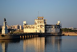
 Lakhota Lake and museum | |
| Nickname(s): Paris of Saurashtra, Choti Kashi | |
 Location of district in Gujarat | |
| Coordinates: 22°13′N 69°42′E | |
| Country | |
| State | Gujarat |
| Region | Saurashtra |
| Nawanagar | 1540 A.D. |
| Founded by | Jam Rawalji Jadeja |
| Named for | Jam, The title of Jadeja rulers. |
| Headquarters | Jamnagar |
| Area | |
| • Total | 14,184 km2 (5,476 sq mi) |
| Population (2011) | |
| • Total | 2,160,119 |
| • Density | 150/km2 (390/sq mi) |
| Demonym | Halaree |
| Languages | |
| • Official | Gujarati, Hindi |
| Time zone | UTC+5:30 (IST) |
| Vehicle registration | GJ-10 |
| Website | gujaratindia |
Talukas (administrative divisions)
- Jam Jodhpur
- Jodiya
- Dhrol
- Jamnagar
- Jamnagar Rural
- Lalpur
- Kalavad Taluka
Demographics
| Year | Pop. | ±% p.a. |
|---|---|---|
| 1901 | 352,150 | — |
| 1911 | 359,604 | +0.21% |
| 1921 | 359,631 | +0.00% |
| 1931 | 425,463 | +1.70% |
| 1941 | 517,833 | +1.98% |
| 1951 | 616,896 | +1.77% |
| 1961 | 828,419 | +2.99% |
| 1971 | 1,111,343 | +2.98% |
| 1981 | 1,393,076 | +2.29% |
| 1991 | 1,563,558 | +1.16% |
| 2001 | 1,904,278 | +1.99% |
| 2011 | 2,160,119 | +1.27% |
| source:[3] | ||
According to the 2011 census Jamnagar district has a population of 2,160,119,[4] roughly equal to the nation of Namibia[5] or the US state of New Mexico.[6] This gives it a district population ranking of 212th in India (out of a total of 640).[4] The district has a population density of 153 inhabitants per square kilometre (400/sq mi) .[4] Its population growth rate over the decade 2001-2011 was 13.38%.[4] Jamnagar has a sex ratio of 938 females for every 1000 males.[4] It had literacy rate of 66.4% in 2001 which rose impressively in a decade to literacy rate of 74.4% by 2011.[4]
Language
Politics
| No. | Constituency | Name | Party | Remarks | |
|---|---|---|---|---|---|
| 76 | Kalavad (SC) | Pravin Musadiya | INC | ||
| 77 | Jamnagar Rural | Vallabhbhai Dharaviya | INC | resigned | |
| Raghavjibhai Patel | BJP | ||||
| 78 | Jamnagar North | Dharmendrasinh Jadeja (Hakubha) | BJP | ||
| 79 | Jamnagar South | R. C. Faldu | BJP | ||
| 80 | Jamjodhpur | Chirag Kalariya | INC | ||
See also
- Halar
- Jamnagar
References
- "Jamnagar District Map". Mapsofindia.com. 12 September 2011. Retrieved 12 March 2014.
- Mustak Amin Mepani. "Jamnagar the beautiful - Tourist information". Jamnagar.org. Retrieved 12 March 2014.
- Decadal Variation In Population Since 1901
- "District Census 2011". Census2011.co.in. 2011. Retrieved 30 September 2011.
- US Directorate of Intelligence. "Country Comparison:Population". Archived from the original on 13 June 2007. Retrieved 1 October 2011.
Namibia 2,147,585
- "2010 Resident Population Data". U. S. Census Bureau. Archived from the original on 19 October 2013. Retrieved 30 September 2011.
New Mexico - 2,059,179
- "C-16 Population By Religion - Gujarat". census.gov.in. Office of the Registrar General & Census Commissioner, India.
External links
На других языках
[de] Jamnagar (Distrikt)
Der Distrikt Jamnagar (Gujarati: જામનગર જિલ્લો) ist einer von 26 Distrikten des Staates Gujarat in Indien. Die gleichnamige Stadt Jamnagar ist die Hauptstadt des Distrikts. Die letzte Volkszählung im Jahr 2011 ergab eine Gesamtbevölkerungszahl von 1.391.753 Menschen.[1]- [en] Jamnagar district
[ru] Джамнагар (округ)
Джамнагар (гудж. જામનગર જિલ્લો; англ. Jamnagar) — округ в индийском штате Гуджарат, на севере полуострова Катхиявар. Административный центр — город Джамнагар. Площадь округа — 14 125 км². По данным всеиндийской переписи 2001 года население округа составляло 1 904 278 человек. Уровень грамотности взрослого населения составлял 66,48 %, что выше среднеиндийского уровня (59,5 %). Доля городского населения составляла 43,91 %. В округе расположен священный индуистский город Дварка.Другой контент может иметь иную лицензию. Перед использованием материалов сайта WikiSort.org внимательно изучите правила лицензирования конкретных элементов наполнения сайта.
WikiSort.org - проект по пересортировке и дополнению контента Википедии
