world.wikisort.org - India
Halar (Haalaar) is a historical region of western India, located by the Gulf of Kutch coast on the northwestern area of Nawanagar, now Jamnagar, in Gujarat State, on Saurashtra peninsula, roughly corresponding to the present Jamnagar District, Devbhumi Dwarka district, Morbi District and Rajkot District.
This article needs additional citations for verification. (May 2019) |
Halar
Kathiawar | |
|---|---|
Historical region | |
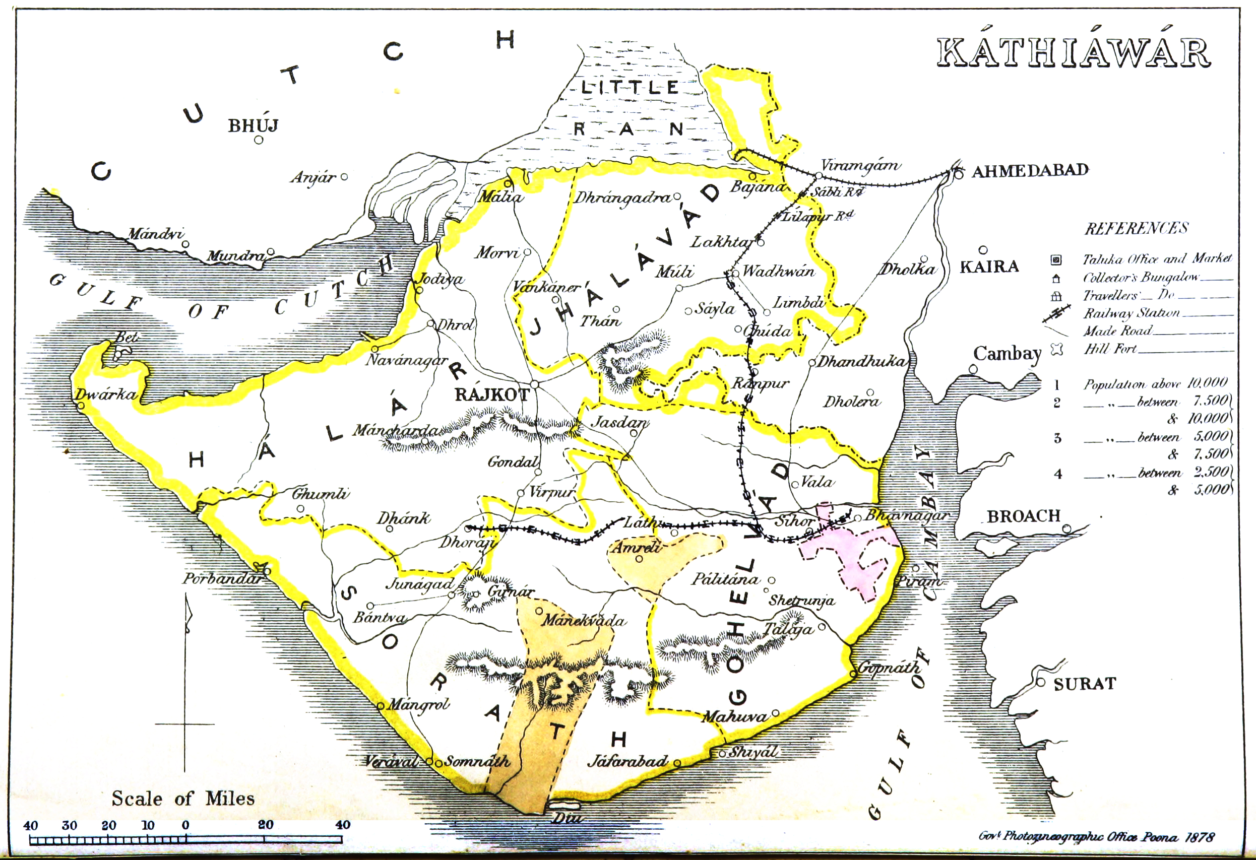 1855 map of Kathiawar | |
| Coordinates: 22°47′N 70°05′E | |
| Country | India |
| State | Gujarat |
| Named for | Hala branch of Jadeja Rajputs. |
| Area | |
| • Total | 19,365 km2 (7,477 sq mi) |
| Population (1901) | |
| • Total | 764,992 |
| • Density | 40/km2 (100/sq mi) |
| Languages | |
| • Official | Gujarati |
| Time zone | UTC+5:30 (IST) |
| Vehicle registration | GJ |
| Website | gujaratindia |
In 1901 it had an area of 19,365km² and a population of 764,992 inhabitants.
History
The name is derived from Jam Sri Halaji Jadeja who is supposed to be the 9th-generation grandfather of Jam Sri Rawalji Lakhaji Jadeja (who is the founder of the region and the first king to reign in the region); Halar was first established with this name by Jam Shri Rawalji Lakhaji, a Jadeja Rajput, in 1540.[1]
During the British Raj Halar region was the western of the four prants or historical districts of Kathiawar, belonging to the Bombay Presidency, the others being Gohelwar (southeast), Jhalawar prant(north) and Sorath (southwest).
Princely States in Halar region
| Princely state |
|---|
|
| Individual residencies |
|
| Agencies |
|
| Lists |
|
At that time the region included numerous princely states belonging to the Kathiawar Agency, mostly ruled by Jadeja Rajputs.[2]
Its salute states were :
- First Class states :
- Nawanagar, title Maharaja Jam Sahib, Hereditary salute of 15-guns (19-guns locally)
- Gondal, title Maharaja, Hereditary salute of 11-guns
- Morvi, title Maharaja, Hereditary salute of 11-guns
- Second Class states :
- Dhrol, title Thakore Sahib, Hereditary salute of 9-guns
- Rajkot, title Thakore Sahib, Hereditary salute of 9-guns
Its major non-salute states (mostly minor, usually several village) included :
- Fourth Class states : Kotda Sangani, Malia, Virpur
- Fifth Class states : Gavridad, Jalia Devani, Kotharia, Rajpara, Mengni, Pal
- Sixth Class states : Bhadva.
- Seventh Class states : Khirasra, Lodhika
Other non-salute state, granted no class, were :
- multiple villages, yet mostly minor except the first : DHRAFA State (known as DHRAFA 24C , means 24 villages under Dhrafa's rule) Amran, Kanpar Ishwaria, Mulila Deri, Satodad Vavdi, Sisang Chandli,
- single village, petty states : Bhalgam Baldhoi, Kansiali, Kotda Nayani, Makaji Meghpar,[3] Virvao.
Bibliography
See also
- Kathiawar Peninsula
- Ranchhodji Diwan
References
- "Jadeja History - Jadeja Rajputs". Retrieved 12 November 2016.
- "Imperial Gazetteer2 of India, Volume 13, page 9 -- Imperial Gazetteer of India -- Digital South Asia Library". Retrieved 12 November 2016.
- Mcleod, John (6–9 July 2004). The Rise and Fall of the Kutch Bhayati (PDF). Eighteenth European Conference on Modern South Asian Studies, University of Lund. p. 5. Archived from the original (PDF) on 7 March 2012. Retrieved 13 September 2012.
Другой контент может иметь иную лицензию. Перед использованием материалов сайта WikiSort.org внимательно изучите правила лицензирования конкретных элементов наполнения сайта.
WikiSort.org - проект по пересортировке и дополнению контента Википедии