world.wikisort.org - Germany
Garmisch-Partenkirchen (Bavarian: Garmasch-Partakurch) is a Landkreis (district) in Bavaria, Germany. It is bounded by (from the west and clockwise) the districts of Ostallgäu, Weilheim-Schongau and Bad Tölz-Wolfratshausen, and by the Austrian state of Tyrol.
Garmisch-Partenkirchen | |
|---|---|
District | |
 Flag 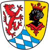 Coat of arms | |
 | |
| Country | Germany |
| State | Bavaria |
| Adm. region | Upper Bavaria |
| Capital | Garmisch-Partenkirchen |
| Area | |
| • Total | 1,012 km2 (391 sq mi) |
| Population (31 December 2020)[1] | |
| • Total | 88,279 |
| • Density | 87/km2 (230/sq mi) |
| Time zone | UTC+01:00 (CET) |
| • Summer (DST) | UTC+02:00 (CEST) |
| Vehicle registration | GAP |
| Website | landratsamt-gap.de |
History
In medieval times the alpine lands were owned by the bishops of Freising and the abbots of Ettal Abbey. In 1803, when the clerical states of Germany were dissolved, the region was acquired by Bavaria.
Geography
The district is located in the Bavarian Alps and includes the highest mountain of Germany, the Zugspitze (2962 m). The highest peaks are grouped along the Austrian border, where the mountain ridges of the Wettersteingebirge and the Karwendelgebirge rise. Between them the Isar river runs northwards. North of these ridges there is a valley housing the tourist resort of Garmisch-Partenkirchen. The valley together with the surrounding mountains is called the Werdenfelser Land. Further north the ridges of the Ammergebirge and the Estergebirge rise, which are still over 2000 m high. In the northernmost parts of the district there is alpine uplands (about 600 m high). Here the Staffelsee is located, a lake of 8 km².
Coat of arms
The coat of arms displays:
- a lion with the head of a griffin, being the symbol of Steingaden Abbey
- a portrait of a moor, often used in European coats of arms (https://blackcentraleurope.com/sources/1000-1500/moors-on-crests/
- the white and blue checked pattern of Bavariahttps:
Towns and municipalities
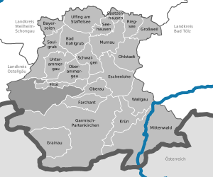
The district includes no towns. All places have the status of municipalities.
References
- "Tabellenblatt "Daten 2", Statistischer Bericht A1200C 202041 Einwohnerzahlen der Gemeinden, Kreise und Regierungsbezirke". Bayerisches Landesamt für Statistik (in German). June 2021.
External links
- Garmisch Partenkirchen, City Guide on Garmisch Partenkirchen Germany
- Official website (German)
- Regional news platform for the Landkreis Garmisch-Partenkirchen (German)
- Zugspitze (German, English)
Towns and municipalities in Garmisch-Partenkirchen (district) | ||
|---|---|---|
 | ||
Authority control | |
|---|---|
| General | |
| National libraries | |
На других языках
[de] Landkreis Garmisch-Partenkirchen
Der Landkreis Garmisch-Partenkirchen liegt im Südwesten des bayerischen Regierungsbezirks Oberbayern.- [en] Garmisch-Partenkirchen (district)
[ru] Гармиш-Партенкирхен (район)
Гармиш-Партенкирхен (нем. Garmisch-Partenkirchen) — район в Германии. Центр района — город Гармиш-Партенкирхен. Район входит в землю Бавария. Подчинён административному округу Верхняя Бавария. Занимает площадь 1012,28 км². Население — 87 590 чел. Плотность населения — 87 человек/км². Официальный код района — 09 1 80.Другой контент может иметь иную лицензию. Перед использованием материалов сайта WikiSort.org внимательно изучите правила лицензирования конкретных элементов наполнения сайта.
WikiSort.org - проект по пересортировке и дополнению контента Википедии