world.wikisort.org - Germany
Wunsiedel (German: Landkreis Wunsiedel i. Fichtelgebirge) is a Landkreis (district) in the northeastern part of Bavaria, Germany. Neighbouring districts are (from the south clockwise) Tirschenreuth, Bayreuth, Hof, and to the east the Czech Karlovy Vary Region.
Wunsiedel | |
|---|---|
District | |
 Flag Coat of arms | |
 | |
| Country | Germany |
| State | Bavaria |
| Adm. region | Upper Franconia |
| Capital | Wunsiedel |
| Area | |
| • Total | 606.40 km2 (234.13 sq mi) |
| Population (31 December 2020)[1] | |
| • Total | 71,974 |
| • Density | 120/km2 (310/sq mi) |
| Time zone | UTC+01:00 (CET) |
| • Summer (DST) | UTC+02:00 (CEST) |
| Vehicle registration | WUN, MAK, REH, SEL |
| Website | landkreis-wunsiedel.de |
Geography
The district is located in the mountains of the Fichtelgebirge, with the highest elevation the 1051 m high Schneeberg. The river Ohře (German: Eger) originates in the district.
History
In the Bavarian communal reforms of 1972 the district was merged with the previously district-free cities Marktredwitz and Selb, as well as parts of the dissolved district of Rehau.
Coat of arms
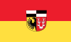
The coat of arms shows an eagle in the bottom left as the symbol of the city Marktredwitz, and a deer antler to the right as the symbol of the city Selb. In the top are the black-and-white symbol of the Zollern dynasty. The coat of arms was granted in 1974.
Towns and municipalities

| Towns | Municipalities |
|---|---|
|
¹ administrated inside a Verwaltungsgemeinschaft | |
References
- "Tabellenblatt "Daten 2", Statistischer Bericht A1200C 202041 Einwohnerzahlen der Gemeinden, Kreise und Regierungsbezirke". Bayerisches Landesamt für Statistik (in German). June 2021.
External links
- Official website (German)
Towns and municipalities in Wunsiedel (district) | ||
|---|---|---|
Authority control | |
|---|---|
| General | |
| National libraries | |
На других языках
[de] Landkreis Wunsiedel im Fichtelgebirge
Der Landkreis Wunsiedel im Fichtelgebirge, amtlich Landkreis Wunsiedel i. Fichtelgebirge, ist ein Landkreis im Osten des Regierungsbezirks Oberfranken in Bayern. Der Landkreis ist Mitglied der Metropolregion Nürnberg, der Wirtschaftsregion Hochfranken und Planungsregion Oberfranken-Ost.- [en] Wunsiedel (district)
[ru] Вунзидель-им-Фихтельгебирге
Вунзидель-им-Фихтельгебирге (нем. Wunsiedel im Fichtelgebirge) — район в Германии, в административном округе Верхняя Франкония Республики Бавария[2]. Центр района — город Вунзидель. Региональный шифр — 09 479.[1] Регистрационные номера транспортных средств (нем. Kraftfahrzeugkennzeichen) — WUN, MAK, REH, SEL.Другой контент может иметь иную лицензию. Перед использованием материалов сайта WikiSort.org внимательно изучите правила лицензирования конкретных элементов наполнения сайта.
WikiSort.org - проект по пересортировке и дополнению контента Википедии