world.wikisort.org - Germany
Deggendorf is a Landkreis (district) in Bavaria, Germany. It is bordered by (from the north and clockwise) the districts of Regen, Freyung-Grafenau, Passau, Rottal-Inn, Dingolfing-Landau and Straubing-Bogen.
Deggendorf | |
|---|---|
District | |
 Flag  Coat of arms | |
 | |
| Country | Germany |
| State | Bavaria |
| Adm. region | Lower Bavaria |
| Capital | Deggendorf |
| Government | |
| • District admin. | Christian Bernreiter |
| Area | |
| • Total | 861 km2 (332 sq mi) |
| Population (31 December 2020)[1] | |
| • Total | 119,479 |
| • Density | 140/km2 (360/sq mi) |
| Time zone | UTC+01:00 (CET) |
| • Summer (DST) | UTC+02:00 (CEST) |
| Vehicle registration | DEG |
| Website | landkreis-deggendorf.de |
History
The district was established in 1936. Minor changes of the borders occurred in 1972 and led to the present form of the district.
Geography
The Danube river runs through the district from west to east, dividing it into two unequal regions. North of the Danube the Bavarian Forest rises steeply. In the south there is relatively plain countryside. The Isar river enters the district in the south and meets the Danube close to the town of Deggendorf. The Einödriegel (1,220 m) is the highest point within the county.
Coat of arms
The double eagle was the symbol of the monastery of Metten, which was the first Christian outpost in the region. The blue line stands for the river Danube, the green hills symbolise the Bavarian Forest.
Towns and municipalities
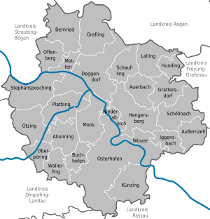
| Towns | Municipalities | |
|---|---|---|
References
- "Tabellenblatt "Daten 2", Statistischer Bericht A1200C 202041 Einwohnerzahlen der Gemeinden, Kreise und Regierungsbezirke". Bayerisches Landesamt für Statistik (in German). June 2021.
External links
- Official website (German)
Towns and municipalities in Deggendorf (district) | ||
|---|---|---|
 | ||
На других языках
[de] Landkreis Deggendorf
Der Landkreis Deggendorf liegt in der Mitte des bayerischen Regierungsbezirks Niederbayern. Mit 119.204 Einwohnern gehört er zu den mittelgroßen Landkreisen in Bayern. Geografisch wird der Landkreis Deggendorf durch die Donau in zwei Teile getrennt: die eine Hälfte ist geprägt durch die Ausläufer des Bayerischen Waldes, die andere Seite durch die fruchtbaren Ebenen des Gäubodens. Zudem mündet im Landkreis Deggendorf die Isar in die Donau. Durch seine Lage im Bayerischen Wald sowie im Bayerischen Golf- und Thermenland ist der Landkreis eine beliebte Tourismusregion.- [en] Deggendorf (district)
[ru] Деггендорф (район)
Деггендорф (нем. Deggendorf) — район в Германии. Центр района — город Деггендорф. Район входит в землю Бавария. Подчинён административному округу Нижняя Бавария. Занимает площадь 861,13 км². Население — 117 492 чел. Плотность населения — 136 человек/км². Официальный код района — 09 2 71.Другой контент может иметь иную лицензию. Перед использованием материалов сайта WikiSort.org внимательно изучите правила лицензирования конкретных элементов наполнения сайта.
WikiSort.org - проект по пересортировке и дополнению контента Википедии