world.wikisort.org - Germany
Amberg-Sulzbach (Northern Bavarian: Amberg-Suizboch) is a Landkreis (district) in Bavaria, Germany. It surrounds but does not include the city of Amberg. It is bounded by (from the north and clockwise) the districts of Neustadt an der Waldnaab, Schwandorf, Neumarkt, Nürnberger Land and Bayreuth.
This article may be expanded with text translated from the corresponding article in German. (June 2020) Click [show] for important translation instructions.
|
This article needs additional citations for verification. (March 2013) |
Amberg-Sulzbach | |
|---|---|
District | |
 Flag Coat of arms | |
 | |
| Country | Germany |
| State | Bavaria |
| Adm. region | Upper Palatinate |
| Founded | 1972-07-01 |
| Capital | Amberg |
| Government | |
| • District admin. | Richard Reisinger (CSU) |
| Area | |
| • Total | 1,255 km2 (485 sq mi) |
| Population (31 December 2020)[1] | |
| • Total | 102,998 |
| • Density | 82/km2 (210/sq mi) |
| Time zone | UTC+01:00 (CET) |
| • Summer (DST) | UTC+02:00 (CEST) |
| Vehicle registration | AS, BUL, ESB, NAB, SUL |
| Website | kreis-as.de |
History
The history is linked with the history of the Upper Palatinate and the city of Amberg.
The district was established in 1972 by merging the former district of Amberg and the district-free city of Sulzbach-Rosenberg (the latter one lost its status as a district-free city in this administrative reform).
Geography
The district is located in the geographical centre of Bavaria, 40 km east of Nuremberg. The main axis of the region is the Vils River (an affluent of the Naab) crossing the district from north to south. West of the river the land rises to the Franconian Jura, while there are gentle hills on the eastern side in the angle between Naab and Vils. The district is mainly covered by forests, especially in its western half.
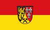
Coat of arms

The coat of arms displays:
- The Palatine Lion, which was the heraldic animal of the Upper Palatinate
- The lilies, which were a symbol of the counts of Sulzbach
- The mining tools, in order to remind of the mining history of the Upper Palatinate
Towns and municipalities

| Towns | Municipalities | |
|---|---|---|
References
- "Tabellenblatt "Daten 2", Statistischer Bericht A1200C 202041 Einwohnerzahlen der Gemeinden, Kreise und Regierungsbezirke". Bayerisches Landesamt für Statistik (in German). June 2021.
External links
- Official website (German)
- Tourist information (German, French; English and Czech versions in process)
Towns and municipalities in Amberg-Sulzbach | ||
|---|---|---|
|  | |
На других языках
[de] Landkreis Amberg-Sulzbach
Der Landkreis Amberg-Sulzbach liegt im Westen des bayerischen Regierungsbezirks Oberpfalz. Die kreisfreie Stadt Amberg ist ganz vom Landkreis Amberg-Sulzbach umgeben. Die verwaltende Kreisbehörde ist das Landratsamt Amberg-Sulzbach. Der Landkreis ist Mitglied der Metropolregion Nürnberg.- [en] Amberg-Sulzbach
[ru] Амберг-Зульцбах
Амберг-Зульцбах (нем. Amberg-Sulzbach) — район в Германии. Центр района — город Амберг. Район входит в землю Бавария. Подчинён административному округу Верхний Пфальц. Занимает площадь 1255 км². Население — 107 794 чел. Плотность населения — 86 человек/км². Официальный код района — 09 3 71.Другой контент может иметь иную лицензию. Перед использованием материалов сайта WikiSort.org внимательно изучите правила лицензирования конкретных элементов наполнения сайта.
WikiSort.org - проект по пересортировке и дополнению контента Википедии