world.wikisort.org - Germany
Hirschau (German pronunciation: [ˈhɪʁʃaʊ̯] (![]() listen)) is a municipality in the Amberg-Sulzbach district, Upper Palatinate, Bavaria, Germany.
listen)) is a municipality in the Amberg-Sulzbach district, Upper Palatinate, Bavaria, Germany.
This article needs additional citations for verification. (July 2008) |
Hirschau | |
|---|---|
Municipality | |
 Hirschau seen from Monte Kaolino | |
 Flag  Coat of arms | |
Location of Hirschau within Amberg-Sulzbach district 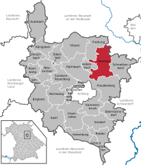 | |
 Hirschau  Hirschau | |
| Coordinates: 49°32′N 11°57′E | |
| Country | Germany |
| State | Bavaria |
| Admin. region | Upper Palatinate |
| District | Amberg-Sulzbach |
| Government | |
| • Mayor (2020–26) | Hermann Falk[1] (CSU) |
| Area | |
| • Total | 74.90 km2 (28.92 sq mi) |
| Elevation | 411 m (1,348 ft) |
| Population (2020-12-31)[2] | |
| • Total | 5,604 |
| • Density | 75/km2 (190/sq mi) |
| Time zone | UTC+01:00 (CET) |
| • Summer (DST) | UTC+02:00 (CEST) |
| Postal codes | 92242 |
| Dialling codes | 09622 |
| Vehicle registration | AS |
| Website | hirschau.de |
Geography
Hirschau lies directly on the Bundesstraße 14 (Nuremberg - Rozvadov), 13 km northeast of Amberg and about 65 km east of Nuremberg. Apart from the main village Hirschau, the municipality consists of the following villages:
- Burgstall
- Dienhof
- Ehenfeld
- Krickelsdorf
- Kricklhof
- Krondorf
- Massenricht
- Obersteinbach
- Steiningloh
- Untersteinbach
- Weiher
Economy
Kaolin, used for the production of porcelain, has been mined at Hirschau since 1901. Interesting is the Monte Kaolino, a 120 meter high mound made from 32,000,000 tons of quartz sand from excess sand in years of operation. It is now used as a (sand) skiing/camping resort during the summer months. It is also the place where the yearly Sandboarding Championships are held.
References
- Liste der ersten Bürgermeister/Oberbürgermeister in kreisangehörigen Gemeinden, Bayerisches Landesamt für Statistik, 15 July 2021.
- "Tabellenblatt "Daten 2", Statistischer Bericht A1200C 202041 Einwohnerzahlen der Gemeinden, Kreise und Regierungsbezirke". Bayerisches Landesamt für Statistik (in German). June 2021.
Towns and municipalities in Amberg-Sulzbach | ||
|---|---|---|
|  | |
Authority control | |
|---|---|
| General | |
| National libraries | |
This Amberg-Sulzbach location article is a stub. You can help Wikipedia by expanding it. |
На других языках
[de] Hirschau
Hirschau ist eine Stadt im Landkreis Amberg-Sulzbach in Bayern und zählt zur Metropolregion Nürnberg. Das Wirtschaftsleben ist von Unternehmen geprägt, welche die umfangreichen Kaolinvorkommen abbauen. Zudem hat hier die Firma Conrad Electronic ihren Sitz.- [en] Hirschau
[ru] Хиршау
Хиршау (нем. Hirschau) — город в Германии, в земле Бавария.Другой контент может иметь иную лицензию. Перед использованием материалов сайта WikiSort.org внимательно изучите правила лицензирования конкретных элементов наполнения сайта.
WikiSort.org - проект по пересортировке и дополнению контента Википедии