world.wikisort.org - Germany
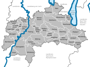
Weilheim-Schongau is a Landkreis (district) in the south of Bavaria, Germany. Neighboring districts are (from the north clockwise) Landsberg, Starnberg, Bad Tölz-Wolfratshausen, Garmisch-Partenkirchen and Ostallgäu.
Weilheim-Schongau | |
|---|---|
District | |
 Flag  Coat of arms | |
 | |
| Country | Germany |
| State | Bavaria |
| Adm. region | Upper Bavaria |
| Capital | Weilheim |
| Area | |
| • Total | 966.22 km2 (373.06 sq mi) |
| Population (31 December 2020)[1] | |
| • Total | 136,134 |
| • Density | 140/km2 (360/sq mi) |
| Time zone | UTC+01:00 (CET) |
| • Summer (DST) | UTC+02:00 (CEST) |
| Vehicle registration | WM, SOG |
| Website | http://www.weilheim-schongau.de |
Geography
The district is located in the northern foothills of the Alps. The main rivers of the district are the Lech and the Ammer. The Ammersee and the Starnberger See are at the northern boundary of the district.
History
The district was formed in 1972 by merging the former districts Weilheim and Schongau, and one municipality from the former district Marktoberdorf.
Coat of arms
The coat of arms combines the symbols of the two precursor districts. The lion in top as the symbol of the Hohenstaufen dynasty was taken from the coat of arms of the district Weilheim. The crosier and the mining tools in the bottom are derived from the coat of arms of the district Schongau, symbolizing both the important monasteries as well as the coal mining in the district.
Towns and municipalities
| Towns | Municipalities | |
|---|---|---|
|
|
References
- "Tabellenblatt "Daten 2", Statistischer Bericht A1200C 202041 Einwohnerzahlen der Gemeinden, Kreise und Regierungsbezirke". Bayerisches Landesamt für Statistik (in German). June 2021.
External links
- Official website (German)
На других языках
[de] Landkreis Weilheim-Schongau
Der Landkreis Weilheim-Schongau liegt im Südwesten des bayerischen Regierungsbezirks Oberbayern. Der Landkreis entstand in der jetzigen Form 1972 aus der Zusammenlegung der Landkreise Weilheim in Oberbayern und Schongau.- [en] Weilheim-Schongau
[ru] Вайльхайм-Шонгау
Вайльхайм-Шонгау (нем. Weilheim-Schongau) — район в Германии, в административном округе Верхняя Бавария Республики Бавария[2]. Центр района — город Вайльхайм. Региональный шифр — 09 1 90.[1] Регистрационные номера транспортных средств — WM.Другой контент может иметь иную лицензию. Перед использованием материалов сайта WikiSort.org внимательно изучите правила лицензирования конкретных элементов наполнения сайта.
WikiSort.org - проект по пересортировке и дополнению контента Википедии