world.wikisort.org - Germany
Nürnberger Land is a Landkreis (district) in Bavaria, Germany. It is bounded by (from the north and clockwise) the districts of Forchheim, Bayreuth, Amberg-Sulzbach, Neumarkt, Roth and Erlangen-Höchstadt, and by the city of Nuremberg.
This article may be expanded with text translated from the corresponding article in German. (November 2021) Click [show] for important translation instructions.
|
Nürnberger Land | |
|---|---|
District | |
 Flag 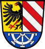 Coat of arms | |
 | |
| Country | Germany |
| State | Bavaria |
| Adm. region | Middle Franconia |
| Capital | Lauf an der Pegnitz |
| Area | |
| • Total | 800 km2 (300 sq mi) |
| Population (31 December 2020)[1] | |
| • Total | 171,143 |
| • Density | 210/km2 (550/sq mi) |
| Time zone | UTC+01:00 (CET) |
| • Summer (DST) | UTC+02:00 (CEST) |
| Vehicle registration | LAU, ESB, HEB, N, PEG |
| Website | nuernberger-land.de |
History
The district was established in 1972 by merging the former districts of Nuremberg, Hersbruck and Lauf, reuniting for the first time since 1789 most of the former lands of the Imperial City of Nuremberg.
Geography
The district includes the eastern metropolitan area of Nuremberg in the west and the hills of the Frankish Alb in the east. The Pegnitz River runs through the district, coming from the northeast and leaving to the west towards Nuremberg.
Coat of arms
The upper part of the coat of arms is identical to the city arms of Nuremberg. In the bottom part there is a water wheel representing the watermills on the river Pegnitz.
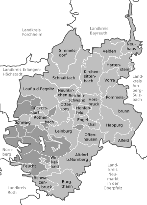
Towns and municipalities
| Towns | Municipalities | |
|---|---|---|
References
- "Tabellenblatt "Daten 2", Statistischer Bericht A1200C 202041 Einwohnerzahlen der Gemeinden, Kreise und Regierungsbezirke". Bayerisches Landesamt für Statistik (in German). June 2021.
External links
- Official website (German)
- Schwaig bei Nürnberg (German)
Authority control | |
|---|---|
| General | |
| National libraries | |
На других языках
[de] Landkreis Nürnberger Land
Der Landkreis Nürnberger Land ist der östlichste Landkreis im bayerischen Regierungsbezirk Mittelfranken. Der Landkreis ist Mitglied der Metropol- und der Planungsregion Nürnberg.- [en] Nürnberger Land
[ru] Нюрнбергер-Ланд
Нюрнбергер-Ланд (нем. Nürnberger Land) — район в Германии. Центр района — город Лауф-ан-дер-Пегниц. Район входит в землю Бавария. Подчинён административному округу Средняя Франкония. Занимает площадь 800,09 км². Население — 168 388 чел. Плотность населения — 210 человек/км². Официальный код района — 09 5 74.Другой контент может иметь иную лицензию. Перед использованием материалов сайта WikiSort.org внимательно изучите правила лицензирования конкретных элементов наполнения сайта.
WikiSort.org - проект по пересортировке и дополнению контента Википедии