world.wikisort.org - Germany
Dingolfing-Landau is a Landkreis (district) in Bavaria, Germany. It is bounded by (from the north and clockwise) the districts of Straubing-Bogen, Deggendorf, Rottal-Inn and Landshut.
Dingolfing-Landau | |
|---|---|
District | |
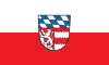 Flag 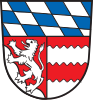 Coat of arms | |
 | |
| Country | Germany |
| State | Bavaria |
| Adm. region | Lower Bavaria |
| Capital | Dingolfing |
| Area | |
| • Total | 878 km2 (339 sq mi) |
| Population (31 December 2020)[1] | |
| • Total | 97,244 |
| • Density | 110/km2 (290/sq mi) |
| Time zone | UTC+01:00 (CET) |
| • Summer (DST) | UTC+02:00 (CEST) |
| Vehicle registration | DGF |
| Website | lra-dgf.bayern.de |
History
The district was established in 1972 by merging the former districts of Dingolfing and Landau (Isar). Its original name was Untere Isar ("Lower Isar"), but in 1973 it was renamed and got its present name.
Geography
The region is characterised by very plain countryside and several rivers running from southwest to northeast (towards the Danube). Most important rivers of the district are the Isar and the Vils.
Economy
The whole region depends on the automobile industry. At Dingolfing, you can find the largest BMW-Industry complex in the world.
Coat of arms
The coat of arms displays:
- The blue and white checkered pattern of Bavaria
- The lion from the arms of the county of Leonberg (once ruling in Landau)
- The red and white bars are from the arms of the county of Frontenhausen (once ruling in Dingolfing)
Towns and municipalities

| Towns | Municipalities | |
|---|---|---|
References
- "Tabellenblatt "Daten 2", Statistischer Bericht A1200C 202041 Einwohnerzahlen der Gemeinden, Kreise und Regierungsbezirke". Bayerisches Landesamt für Statistik (in German). June 2021.
External links
Wikimedia Commons has media related to Landkreis Dingolfing-Landau.
Towns and municipalities in Dingolfing-Landau | ||
|---|---|---|
На других языках
[de] Landkreis Dingolfing-Landau
Der Landkreis Dingolfing-Landau liegt in der westlichen Mitte des bayerischen Regierungsbezirks Niederbayern.- [en] Dingolfing-Landau
[ru] Дингольфинг-Ландау
Дингольфинг-Ландау (нем. Dingolfing-Landau) — район в Германии. Центр района — город Дингольфинг. Район входит в землю Бавария. Подчинён административному округу Нижняя Бавария. Занимает площадь 877,8 км². Население — 92 123 чел. Плотность населения — 105 человек/км². Официальный код района — 09 2 79.Текст в блоке "Читать" взят с сайта "Википедия" и доступен по лицензии Creative Commons Attribution-ShareAlike; в отдельных случаях могут действовать дополнительные условия.
Другой контент может иметь иную лицензию. Перед использованием материалов сайта WikiSort.org внимательно изучите правила лицензирования конкретных элементов наполнения сайта.
Другой контент может иметь иную лицензию. Перед использованием материалов сайта WikiSort.org внимательно изучите правила лицензирования конкретных элементов наполнения сайта.
2019-2026
WikiSort.org - проект по пересортировке и дополнению контента Википедии
WikiSort.org - проект по пересортировке и дополнению контента Википедии