world.wikisort.org - France
Saint-Sauveur-d'Émalleville is a commune in the Seine-Maritime department in the Normandy region in northern France.
Saint-Sauveur-d'Émalleville | |
|---|---|
Commune | |
 Coat of arms | |
Location of Saint-Sauveur-d'Émalleville  | |
 Saint-Sauveur-d'Émalleville  Saint-Sauveur-d'Émalleville | |
| Coordinates: 49°36′46″N 0°17′59″E | |
| Country | France |
| Region | Normandy |
| Department | Seine-Maritime |
| Arrondissement | Le Havre |
| Canton | Saint-Romain-de-Colbosc |
| Intercommunality | CC Campagne de Caux |
| Government | |
| • Mayor (2020–2026) | Anthony Bayou[1] |
| Area 1 | 7.48 km2 (2.89 sq mi) |
| Population | 1,229 |
| • Density | 160/km2 (430/sq mi) |
| Time zone | UTC+01:00 (CET) |
| • Summer (DST) | UTC+02:00 (CEST) |
| INSEE/Postal code | 76650 /76110 |
| Elevation | 104–137 m (341–449 ft) (avg. 120 m or 390 ft) |
| 1 French Land Register data, which excludes lakes, ponds, glaciers > 1 km2 (0.386 sq mi or 247 acres) and river estuaries. | |
Geography
A farming village in the Pays de Caux, situated some 12 miles (19 km) northeast of Le Havre, on the D925 road.
Heraldry
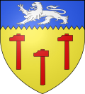 |
The arms of Saint-Sauveur-d'Émalleville are blazoned : Or, 3 hammers gules, on a chief indented azure a lion passant argent.
|
Population
| Year | Pop. | ±% p.a. |
|---|---|---|
| 1968 | 321 | — |
| 1975 | 428 | +4.20% |
| 1982 | 782 | +8.99% |
| 1990 | 862 | +1.22% |
| 1999 | 968 | +1.30% |
| 2007 | 1,165 | +2.34% |
| 2012 | 1,191 | +0.44% |
| 2017 | 1,214 | +0.38% |
| Source: INSEE[3] | ||
Places of interest
- The thirteenth-century church at the priory of St. Sauveur.
- The church of St. Anne, dating from the twelfth century.
See also
References
- "Répertoire national des élus: les maires". data.gouv.fr, Plateforme ouverte des données publiques françaises (in French). 2 December 2020.
- "Populations légales 2019". The National Institute of Statistics and Economic Studies. 29 December 2021.
- Population en historique depuis 1968, INSEE
Wikimedia Commons has media related to Saint-Sauveur-d'Émalleville.
На других языках
- [en] Saint-Sauveur-d'Émalleville
[es] Saint-Sauveur-d'Émalleville
Saint-Sauveur-d'Émalleville es una población y comuna francesa, en la región de Alta Normandía, departamento de Sena Marítimo, en el distrito de Le Havre y cantón de Goderville.Текст в блоке "Читать" взят с сайта "Википедия" и доступен по лицензии Creative Commons Attribution-ShareAlike; в отдельных случаях могут действовать дополнительные условия.
Другой контент может иметь иную лицензию. Перед использованием материалов сайта WikiSort.org внимательно изучите правила лицензирования конкретных элементов наполнения сайта.
Другой контент может иметь иную лицензию. Перед использованием материалов сайта WikiSort.org внимательно изучите правила лицензирования конкретных элементов наполнения сайта.
2019-2025
WikiSort.org - проект по пересортировке и дополнению контента Википедии
WikiSort.org - проект по пересортировке и дополнению контента Википедии