world.wikisort.org - France
Darnétal (French pronunciation: [daʁnetal]; Norman: Dernétal) is a commune in the Seine-Maritime department in the Normandy region in northern France.
Darnétal | |
|---|---|
Commune | |
 The church of Carville | |
 Coat of arms | |
Location of Darnétal  | |
 Darnétal  Darnétal | |
| Coordinates: 49°26′43″N 1°09′07″E | |
| Country | France |
| Region | Normandy |
| Department | Seine-Maritime |
| Arrondissement | Rouen |
| Canton | Darnétal |
| Intercommunality | Métropole Rouen Normandie |
| Government | |
| • Mayor (2020–2026) | Christian Lecerf |
| Area 1 | 4.93 km2 (1.90 sq mi) |
| Population | 9,788 |
| • Density | 2,000/km2 (5,100/sq mi) |
| Time zone | UTC+01:00 (CET) |
| • Summer (DST) | UTC+02:00 (CEST) |
| INSEE/Postal code | 76212 /76160 |
| Elevation | 13–143 m (43–469 ft) (avg. 22 m or 72 ft) |
| 1 French Land Register data, which excludes lakes, ponds, glaciers > 1 km2 (0.386 sq mi or 247 acres) and river estuaries. | |
Geography
A light industrial suburban town surrounded by woodland, situated some 2 miles (3.2 km) east of the centre of Rouen at the junction of the D43, D15 and the N31 roads. Two small rivers flow through the town, the Robec and the Aubette.
SNCF operates a TER service, having a railway station in the town.
Heraldry
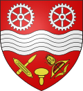 |
The arms of Darnétal are blazoned : Gules, a fess wavy [river] between two gear wheels argent and, in base, a printers stamp between, to dexter a weaver's shuttle and its bobbin in saltire, and to sinister a ?linen? shuttle with its ?teasel? in saltire Or.
|
Population
| Year | Pop. | ±% p.a. |
|---|---|---|
| 1968 | 11,062 | — |
| 1975 | 11,765 | +0.88% |
| 1982 | 10,081 | −2.18% |
| 1990 | 9,779 | −0.38% |
| 1999 | 9,225 | −0.65% |
| 2007 | 9,429 | +0.27% |
| 2012 | 9,418 | −0.02% |
| 2017 | 9,707 | +0.61% |
| Source: INSEE[2] | ||
Places of interest
- The churches of St.Ouen and of St.Pierre, both dating from the sixteenth century.
- Traces of a feudal castle.
- A restored watermill.
Notable people
- The activist René Valentin Binet, (1913–1957) was born here.
- Blessed Father Jacques Hamel (1930-2016), first priest to be killed by ISIL in Europe.
See also
References
- "Populations légales 2019". The National Institute of Statistics and Economic Studies. 29 December 2021.
- Population en historique depuis 1968, INSEE
External links
Wikimedia Commons has media related to Darnétal.
Wikisource has the text of the Encyclopædia Britannica (9th ed.) article Darnétal.
- Official Darnétal website (in French)
- Darnétal Festival website (in French)
Authority control | |
|---|---|
| General |
|
| National libraries | |
На других языках
[de] Darnétal
Vorlage:Infobox Gemeinde in Frankreich/Wartung/abweichendes Wappen in Wikidata- [en] Darnétal
[ru] Дарнеталь
Дарнеталь (фр. Darnétal) — город на севере Франции, регион Нормандия, департамент Приморская Сена, округ Руан, центр одноименного кантона. Пригород Руана, расположен в 5 км к востоку от центра города.Текст в блоке "Читать" взят с сайта "Википедия" и доступен по лицензии Creative Commons Attribution-ShareAlike; в отдельных случаях могут действовать дополнительные условия.
Другой контент может иметь иную лицензию. Перед использованием материалов сайта WikiSort.org внимательно изучите правила лицензирования конкретных элементов наполнения сайта.
Другой контент может иметь иную лицензию. Перед использованием материалов сайта WikiSort.org внимательно изучите правила лицензирования конкретных элементов наполнения сайта.
2019-2026
WikiSort.org - проект по пересортировке и дополнению контента Википедии
WikiSort.org - проект по пересортировке и дополнению контента Википедии