world.wikisort.org - France
Mont-Saint-Aignan (French pronunciation: [mɔ̃ sɛ̃t‿ɛɲɑ̃]) is a commune in the Seine-Maritime department in the region of Normandy, northwestern France.
Mont-Saint-Aignan | |
|---|---|
Commune | |
 The church in Mont-Saint-Aignan | |
 Coat of arms | |
Location of Mont-Saint-Aignan  | |
 Mont-Saint-Aignan  Mont-Saint-Aignan | |
| Coordinates: 49°27′47″N 1°05′18″E | |
| Country | France |
| Region | Normandy |
| Department | Seine-Maritime |
| Arrondissement | Rouen |
| Canton | Mont-Saint-Aignan |
| Intercommunality | Métropole Rouen Normandie |
| Government | |
| • Mayor (2020–2026) | Catherine Flavigny |
| Area 1 | 7.94 km2 (3.07 sq mi) |
| Population | 19,357 |
| • Density | 2,400/km2 (6,300/sq mi) |
| Time zone | UTC+01:00 (CET) |
| • Summer (DST) | UTC+02:00 (CEST) |
| INSEE/Postal code | 76451 /76130 |
| Elevation | 44–171 m (144–561 ft) (avg. 145 m or 476 ft) |
| 1 French Land Register data, which excludes lakes, ponds, glaciers > 1 km2 (0.386 sq mi or 247 acres) and river estuaries. | |
The inhabitants of the town of Mont-Saint-Aignan are "Mont-Saint-Aignanais".[2]
Due to the presence of higher education institutions (notably the University of Rouen and the NEOMA Business School) and the city's relatively small population, Mont-Saint-Aignan is considered the French city that has the largest proportion of students relative to its population (students represented in 2014 25,61% of the total population).[3]
Geography
The town is the fifth-largest suburb of the city of Rouen and lies directly adjacent to the north side of Rouen at the junction of the D121 and D43. In addition to its population of 21,265, there are also around 20,000 students at the University and the various Grandes Écoles.
History
The town is ultimately named for the ancient Saint Aignan of Orleans.
The parishes of Saint-Aignan (Latin: Sanctus Anianus) and Mont-aux-Malades (Monte Infirmorum, which takes its name from a hospital) are mentioned in documents dating back to the 12th century. Henry II built a church there dedicated to Thomas Becket in 1176 in an attempt to make up for his unwitting role in the murder of the Archbishop of Canterbury.
The modern commune of Mont-Saint-Aignan was created in the early 19th century (1815–1819) out of the merger of the communes of Monts-aux-Malades, Saint-Aignan and (partly) Saint-Denis-de-Bondeville.
Heraldry
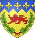 |
Arms of Mont-Saint-Aignan are blazoned : Or, a leopard gules within a laurel wreath vert, and on a chief indented azure, 3 fleurs de lys and 2 half ones Or
|
People
- Jacques Anquetil (1934–1987), first cyclist to win the Tour de France five times
- Viviane Asseyi, footballer
- Ousmane Camara, basketball player
- Flora Coquerel, Miss France 2014
- Maurice Euzennat (1926–2004), historian and archaeologist
- Thierry Foucaud (1954- ), politician
- govy, artist
- Franck Haise, football manager and former player
- Jamel Ait Ben Idir, footballer
- Lagaf', humorist and television presenter
- Sébastien Larcier, footballer
- Pierrick Lebourg, professional footballer
- Matthieu Louis-Jean, footballer
- Jackson Mendy, footballer
- Tony Parker, basketball player
- Mohamed Sissoko, footballer
- Lucien Tesnière (1893–1954), linguist
- Sébastien Le Toux, footballer
Population
|
| ||||||||||||||||||||||||||||||||||||||||||||||||||||||||||||||||||||||||||||||||||||||||||||||||||||||||||||||||||
| Source: EHESS[4] and INSEE (1968-2017)[5] | |||||||||||||||||||||||||||||||||||||||||||||||||||||||||||||||||||||||||||||||||||||||||||||||||||||||||||||||||||
Places of interest
- The church of St. Jacques, dating from the eleventh century, used as a workshop after the Revolution
- The church of St. Thomas, dating from the twelfth century
- The sixteenth century church of St. Aignan
- The nineteenth century church of St. André
- The modern church of Notre-Dame-de-Miséricorde (1970)
- The chapel of the Petit-Séminaire (1862)
- Several ancient houses
Colleges and universities
- University of Rouen
- NEOMA Business School (former École Supérieure de Commerce de Rouen)
- Institut de Formation Internationale (part of the Business School)
- ésitpa (agriculture and agronomy)
- ESIGELEC formerly in Mont-Saint-Aignan; moved in 2004 to nearby Saint-Étienne-du-Rouvray
- Institut National des Sciences Appliquées de Rouen (INSA Rouen) also - since Oct 2009 - now wholly in Saint-Étienne-du-Rouvray
Twin towns – sister cities
Mont-Saint-Aignan is twinned with:[6]
 Barsinghausen, Germany (1967)
 Edenbridge, England (1973)
 Osica de Sus, Romania (1991)
 Brzeg Dolny, Poland (2003)
 Rouko, Burkina Faso (2010)
References
- "Populations légales 2019". The National Institute of Statistics and Economic Studies. 29 December 2021.
- "Commune"
- (in French) Classement des villes étudiantes Archived 2011-06-09 at the Wayback Machine
- Des villages de Cassini aux communes d'aujourd'hui: Commune data sheet Mont-Saint-Aignan, EHESS. (in French)
- Population en historique depuis 1968, INSEE
- "Jumelages". montsaintaignan.fr (in French). Mont-Saint-Aignan. Retrieved 2019-11-20.
External links
- City council website (in French)
- Info website-blog about Mont Saint Aignan (in French)
Authority control | |
|---|---|
| General | |
| National libraries | |
| Other | |
На других языках
- [en] Mont-Saint-Aignan
[ru] Мон-Сен-Эньян
Мон-Сен-Эньян (фр. Mont-Saint-Aignan) — город на севере Франции, регион Нормандия, департамент Приморская Сена, округ Руан, центр одноименного кантона. Пригород Руана, примыкает к нему с северо-запада. Расположен в 4 км от автомагистрали А150. Один из многочисленных городов-спутников Руана, входит в состав Метрополии Руан Нормандия. На территории города располагается университет Руан-Нормандия.Другой контент может иметь иную лицензию. Перед использованием материалов сайта WikiSort.org внимательно изучите правила лицензирования конкретных элементов наполнения сайта.
WikiSort.org - проект по пересортировке и дополнению контента Википедии