world.wikisort.org - France
Molagnies (French pronunciation: [mɔlaɲi]) is a commune in the Seine-Maritime department in the Normandy region in northern France.
Molagnies | |
|---|---|
Commune | |
 Coat of arms | |
Location of Molagnies  | |
 Molagnies  Molagnies | |
| Coordinates: 49°31′16″N 1°43′24″E | |
| Country | France |
| Region | Normandy |
| Department | Seine-Maritime |
| Arrondissement | Dieppe |
| Canton | Gournay-en-Bray |
| Intercommunality | CC 4 rivières |
| Government | |
| • Mayor (2020–2026) | Christian Ducrocq[1] |
| Area 1 | 4.65 km2 (1.80 sq mi) |
| Population | 197 |
| • Density | 42/km2 (110/sq mi) |
| Time zone | UTC+01:00 (CET) |
| • Summer (DST) | UTC+02:00 (CEST) |
| INSEE/Postal code | 76440 /76220 |
| Elevation | 97–183 m (318–600 ft) (avg. 101 m or 331 ft) |
| 1 French Land Register data, which excludes lakes, ponds, glaciers > 1 km2 (0.386 sq mi or 247 acres) and river estuaries. | |
Geography
A small farming village situated by the banks of the Epte river in the Pays de Bray, some 31 miles (50 km) east of Rouen on the D57 road and at the border with the department of Oise.
Heraldry
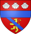 |
The arms of Molagnies are blazoned : Gules, a lion tail raised Or, overall a bend azure, and on a chief gules 3 escallops argent, and ??? a fess azure.
|
Population
| Year | Pop. | ±% p.a. |
|---|---|---|
| 1968 | 84 | — |
| 1975 | 75 | −1.61% |
| 1982 | 83 | +1.46% |
| 1990 | 119 | +4.61% |
| 1999 | 149 | +2.53% |
| 2007 | 152 | +0.25% |
| 2012 | 179 | +3.32% |
| 2017 | 167 | −1.38% |
| Source: INSEE[3] | ||
Places of interest
- The church of St. Manvieu, dating from the thirteenth century.
- A fifteenth century manorhouse.
See also
References
- Liste des maires du département de la Seine-Maritime, 10 August 2020
- "Populations légales 2019". The National Institute of Statistics and Economic Studies. 29 December 2021.
- Population en historique depuis 1968, INSEE
Wikimedia Commons has media related to Molagnies.
На других языках
[de] Molagnies
Vorlage:Infobox Gemeinde in Frankreich/Wartung/abweichendes Wappen in Wikidata- [en] Molagnies
Текст в блоке "Читать" взят с сайта "Википедия" и доступен по лицензии Creative Commons Attribution-ShareAlike; в отдельных случаях могут действовать дополнительные условия.
Другой контент может иметь иную лицензию. Перед использованием материалов сайта WikiSort.org внимательно изучите правила лицензирования конкретных элементов наполнения сайта.
Другой контент может иметь иную лицензию. Перед использованием материалов сайта WikiSort.org внимательно изучите правила лицензирования конкретных элементов наполнения сайта.
2019-2026
WikiSort.org - проект по пересортировке и дополнению контента Википедии
WikiSort.org - проект по пересортировке и дополнению контента Википедии