world.wikisort.org - France
Mont-Cauvaire (French pronunciation: [mɔ̃ kovɛʁ]) is a commune in the Seine-Maritime department in the Normandy region in northern France.
Mont-Cauvaire | |
|---|---|
Commune | |
 The dovecote of the Domaine du Fossé | |
 Coat of arms | |
Location of Mont-Cauvaire  | |
 Mont-Cauvaire  Mont-Cauvaire | |
| Coordinates: 49°34′18″N 1°06′38″E | |
| Country | France |
| Region | Normandy |
| Department | Seine-Maritime |
| Arrondissement | Rouen |
| Canton | Bois-Guillaume |
| Government | |
| • Mayor (2020–2026) | Stéphanie Lambard[1] |
| Area 1 | 9.02 km2 (3.48 sq mi) |
| Population | 840 |
| • Density | 93/km2 (240/sq mi) |
| Time zone | UTC+01:00 (CET) |
| • Summer (DST) | UTC+02:00 (CEST) |
| INSEE/Postal code | 76443 /76690 |
| Elevation | 65–176 m (213–577 ft) (avg. 175 m or 574 ft) |
| 1 French Land Register data, which excludes lakes, ponds, glaciers > 1 km2 (0.386 sq mi or 247 acres) and river estuaries. | |
Geography
A farming village, situated along the banks of the river Cailly in the Pays de Caux, some 10 miles (16 km) north of Rouen on the D3 road.
Heraldry
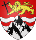 |
The arms of Mont-Cauvaire are blazoned : Gules, 2 fesses wavy abased, with a triple-peaked mount argent over them, in chief a leopard Or armed sable, langued gules, holding a latin cross bendwise sable.
|
Population
| Year | Pop. | ±% p.a. |
|---|---|---|
| 1968 | 451 | — |
| 1975 | 471 | +0.62% |
| 1982 | 557 | +2.42% |
| 1990 | 603 | +1.00% |
| 1999 | 566 | −0.70% |
| 2007 | 611 | +0.96% |
| 2012 | 627 | +0.52% |
| 2017 | 741 | +3.40% |
| Source: INSEE[3] | ||
Places of interest
- The church of St.Martin, dating from the nineteenth century.
- A sixteenth century sandstone cross.
- The seventeenth century Château du Rombosc, with its chapel, and parkland.
- The Château du Fossé, dating from the seventeenth century.
- The eighteenth century Pavillon de La Tourelle and its parkland.
- Two dovecotes and a communal oven.
See also
References
- Liste des maires du département de la Seine-Maritime, 10 August 2020
- "Populations légales 2019". The National Institute of Statistics and Economic Studies. 29 December 2021.
- Population en historique depuis 1968, INSEE
Wikimedia Commons has media related to Mont-Cauvaire.
Authority control | |
|---|---|
| General |
|
| National libraries | |
Текст в блоке "Читать" взят с сайта "Википедия" и доступен по лицензии Creative Commons Attribution-ShareAlike; в отдельных случаях могут действовать дополнительные условия.
Другой контент может иметь иную лицензию. Перед использованием материалов сайта WikiSort.org внимательно изучите правила лицензирования конкретных элементов наполнения сайта.
Другой контент может иметь иную лицензию. Перед использованием материалов сайта WikiSort.org внимательно изучите правила лицензирования конкретных элементов наполнения сайта.
2019-2025
WikiSort.org - проект по пересортировке и дополнению контента Википедии
WikiSort.org - проект по пересортировке и дополнению контента Википедии