world.wikisort.org - France
Bertrimont is a commune in the Seine-Maritime department in the Normandy region in northern France.
This article may be expanded with text translated from the corresponding article in French. (October 2021) Click [show] for important translation instructions.
|
Bertrimont | |
|---|---|
Commune | |
 Coat of arms | |
Location of Bertrimont  | |
 Bertrimont  Bertrimont | |
| Coordinates: 49°40′04″N 1°00′06″E | |
| Country | France |
| Region | Normandy |
| Department | Seine-Maritime |
| Arrondissement | Dieppe |
| Canton | Luneray |
| Intercommunality | CC Terroir de Caux |
| Area 1 | 4.74 km2 (1.83 sq mi) |
| Population | 216 |
| • Density | 46/km2 (120/sq mi) |
| Time zone | UTC+01:00 (CET) |
| • Summer (DST) | UTC+02:00 (CEST) |
| INSEE/Postal code | 76086 /76890 |
| Elevation | 114–162 m (374–531 ft) (avg. 147 m or 482 ft) |
| 1 French Land Register data, which excludes lakes, ponds, glaciers > 1 km2 (0.386 sq mi or 247 acres) and river estuaries. | |
Geography
A small farming village in the Pays de Caux, situated some 20 miles (32 km) south of Dieppe, near the junction of the N29 and the D2 roads.
Heraldry
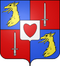 |
The arms of Bertrimont are blazoned : Quarterly 1&4: Azure, a griffon's head Or; 2&3: Gules, a sword argent; overall an inescutcheon Argent, a heart gules.
|
Population
| Year | Pop. | ±% p.a. |
|---|---|---|
| 1968 | 125 | — |
| 1975 | 117 | −0.94% |
| 1982 | 115 | −0.25% |
| 1990 | 124 | +0.95% |
| 1999 | 195 | +5.16% |
| 2007 | 253 | +3.31% |
| 2012 | 225 | −2.32% |
| 2017 | 219 | −0.54% |
| Source: INSEE[2] | ||
Places of interest
- The church of St.Pierre, dating from the sixteenth century.
- The feudal motte.
See also
References
- "Populations légales 2019". The National Institute of Statistics and Economic Studies. 29 December 2021.
- Population en historique depuis 1968, INSEE
Wikimedia Commons has media related to Bertrimont.
На других языках
[de] Bertrimont
Bertrimont ist eine französische Gemeinde mit 216 Einwohnern (Stand 1. Januar 2019) im Département Seine-Maritime in der Region Normandie. Sie gehört zum Arrondissement Dieppe und zum Kanton Luneray. Die Einwohner werden Bertrimontais genannt.- [en] Bertrimont
Текст в блоке "Читать" взят с сайта "Википедия" и доступен по лицензии Creative Commons Attribution-ShareAlike; в отдельных случаях могут действовать дополнительные условия.
Другой контент может иметь иную лицензию. Перед использованием материалов сайта WikiSort.org внимательно изучите правила лицензирования конкретных элементов наполнения сайта.
Другой контент может иметь иную лицензию. Перед использованием материалов сайта WikiSort.org внимательно изучите правила лицензирования конкретных элементов наполнения сайта.
2019-2026
WikiSort.org - проект по пересортировке и дополнению контента Википедии
WikiSort.org - проект по пересортировке и дополнению контента Википедии