world.wikisort.org - France
Roisel (French pronunciation: [ʁwazɛl]) is a commune in the Somme department in Hauts-de-France in northern France.
Roisel | |
|---|---|
Commune | |
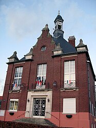
 The town hall in Roisel | |
 Coat of arms | |
Location of Roisel  | |
 Roisel  Roisel | |
| Coordinates: 49°56′47″N 3°05′55″E | |
| Country | France |
| Region | Hauts-de-France |
| Department | Somme |
| Arrondissement | Péronne |
| Canton | Péronne |
| Intercommunality | Haute Somme |
| Government | |
| • Mayor (2020–2026) | Jean-Jacques Flament[1] |
| Area 1 | 10.16 km2 (3.92 sq mi) |
| Population | 1,593 |
| • Density | 160/km2 (410/sq mi) |
| Time zone | UTC+01:00 (CET) |
| • Summer (DST) | UTC+02:00 (CEST) |
| INSEE/Postal code | 80677 /80240 |
| Elevation | 67–142 m (220–466 ft) (avg. 75 m or 246 ft) |
| 1 French Land Register data, which excludes lakes, ponds, glaciers > 1 km2 (0.386 sq mi or 247 acres) and river estuaries. | |
Geography
Roisel is situated 10 miles (16 km) northwest of Saint-Quentin, on the D6 road, with the small river ‘La Cologne’ (a tributary of the Somme) flowing through the commune.
Population
| Year | Pop. | ±% p.a. |
|---|---|---|
| 1968 | 1,908 | — |
| 1975 | 1,846 | −0.47% |
| 1982 | 1,976 | +0.98% |
| 1990 | 1,960 | −0.10% |
| 1999 | 1,929 | −0.18% |
| 2007 | 1,821 | −0.72% |
| 2012 | 1,740 | −0.91% |
| 2017 | 1,613 | −1.50% |
| Source: INSEE[3] | ||
History
The name of Roisel has an etymology close to that of "roseau" (en:reed) and it's possible, given the ponds, lakes and marches, that the commune takes its name from the landscape. Roisel has strong connections with Saint Fursey.
Places of interest
- St Martin's church. Destroyed during World War I, it was rebuilt by local architect Louis Faille, from Nurlu, soon after 1928
- The town hall (Hotel de ville), rebuilt in 1926 by Maurice Lucet].
See also
References
- "Répertoire national des élus: les maires". data.gouv.fr, Plateforme ouverte des données publiques françaises (in French). 2 December 2020.
- "Populations légales 2019". The National Institute of Statistics and Economic Studies. 29 December 2021.
- Population en historique depuis 1968, INSEE
Wikimedia Commons has media related to Roisel.
На других языках
[de] Roisel
Roisel ist eine nordfranzösische Gemeinde mit 1593 Einwohnern (Stand 1. Januar 2019) im Département Somme in der Region Hauts-de-France. Sie liegt am Flüsschen Cologne.- [en] Roisel
[ru] Руазель
Руазель (фр. Roisel) — коммуна на севере Франции, регион О-де-Франс, департамент Сомма, округ Перон, кантон Перон. Расположена в 63 км к востоку от Амьена, в 8 км от автомагистрали А26 "Англия".Текст в блоке "Читать" взят с сайта "Википедия" и доступен по лицензии Creative Commons Attribution-ShareAlike; в отдельных случаях могут действовать дополнительные условия.
Другой контент может иметь иную лицензию. Перед использованием материалов сайта WikiSort.org внимательно изучите правила лицензирования конкретных элементов наполнения сайта.
Другой контент может иметь иную лицензию. Перед использованием материалов сайта WikiSort.org внимательно изучите правила лицензирования конкретных элементов наполнения сайта.
2019-2025
WikiSort.org - проект по пересортировке и дополнению контента Википедии
WikiSort.org - проект по пересортировке и дополнению контента Википедии