world.wikisort.org - France
Saint-Maxent is a commune in the Somme department in Hauts-de-France in northern France.
Saint-Maxent | |
|---|---|
Commune | |
 The town hall in Saint-Maxent | |
Location of Saint-Maxent  | |
 Saint-Maxent  Saint-Maxent | |
| Coordinates: 50°00′25″N 1°43′49″E | |
| Country | France |
| Region | Hauts-de-France |
| Department | Somme |
| Arrondissement | Abbeville |
| Canton | Gamaches |
| Intercommunality | CC Aumale - Blangy-sur-Bresle |
| Government | |
| • Mayor (2020–2026) | Bernard Leneveu |
| Area 1 | 6.38 km2 (2.46 sq mi) |
| Population | 395 |
| • Density | 62/km2 (160/sq mi) |
| Time zone | UTC+01:00 (CET) |
| • Summer (DST) | UTC+02:00 (CEST) |
| INSEE/Postal code | 80710 /80140 |
| Elevation | 93–118 m (305–387 ft) (avg. 114 m or 374 ft) |
| 1 French Land Register data, which excludes lakes, ponds, glaciers > 1 km2 (0.386 sq mi or 247 acres) and river estuaries. | |
Geography
The commune is situated some 10 miles (16 km) southwest of Abbeville, on the D86 and D29 road junction, about a mile from the A28 autoroute.
Population
| Year | Pop. | ±% p.a. |
|---|---|---|
| 1968 | 417 | — |
| 1975 | 379 | −1.36% |
| 1982 | 365 | −0.54% |
| 1990 | 365 | +0.00% |
| 1999 | 369 | +0.12% |
| 2007 | 389 | +0.66% |
| 2012 | 404 | +0.76% |
| 2017 | 392 | −0.60% |
| 2019 | 395 | +0.38% |
| Source: INSEE[2][3] | ||
Places of interest
- The church
- The old railway line [4]
The railway was opened on 9 May 1872 and was used principally from freight, although some passengers were carried.
It was finally closed on 10 November 1993. It served the following communes:
Longpré-les-Corps-Saints / Bettencourt-Rivière / Airaines / Allery / Wiry-au-Mont / Forceville / Oisemont / Cerisy-Buleux / Martainneville / Saint-Maxent / Vismes-au-Val / Maisnières / Longroy and Gamaches

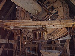
- The mill of Saint-Maxent, 2006


See also
References
- "Populations légales 2019". The National Institute of Statistics and Economic Studies. 29 December 2021.
- Population en historique depuis 1968, INSEE
- Populations légales 2019: 80 Somme, INSEE
- Source:Fcvnet Archived 10 February 2012 at the Wayback Machine
Wikimedia Commons has media related to Saint-Maxent.
На других языках
[de] Saint-Maxent
Saint-Maxent (picardisch: Saint-Manchin) ist eine nordfranzösische Gemeinde mit 395 Einwohnern (Stand 1. Januar 2019) im Département Somme in der Region Hauts-de-France. Die Gemeinde liegt im Arrondissement Abbeville und ist Teil der Communauté de communes interrégionale Aumale Blangy-sur-Bresle und des Kantons Gamaches.- [en] Saint-Maxent
[es] Saint-Maxent
Saint-Maxent es una población y comuna francesa, en la región de Región de Alta Francia, departamento de Somme, en el distrito de Abbeville y cantón de Gamaches.Текст в блоке "Читать" взят с сайта "Википедия" и доступен по лицензии Creative Commons Attribution-ShareAlike; в отдельных случаях могут действовать дополнительные условия.
Другой контент может иметь иную лицензию. Перед использованием материалов сайта WikiSort.org внимательно изучите правила лицензирования конкретных элементов наполнения сайта.
Другой контент может иметь иную лицензию. Перед использованием материалов сайта WikiSort.org внимательно изучите правила лицензирования конкретных элементов наполнения сайта.
2019-2026
WikiSort.org - проект по пересортировке и дополнению контента Википедии
WikiSort.org - проект по пересортировке и дополнению контента Википедии