world.wikisort.org - France
Épécamps (French pronunciation: [epekɑ̃]) is a commune in the Somme department in Hauts-de-France in northern France.
Épécamps | |
|---|---|
Commune | |
 Town hall. | |
Location of Épécamps  | |
 Épécamps  Épécamps | |
| Coordinates: 50°06′48″N 2°09′21″E | |
| Country | France |
| Region | Hauts-de-France |
| Department | Somme |
| Arrondissement | Amiens |
| Canton | Doullens |
| Intercommunality | Territoire Nord Picardie |
| Government | |
| • Mayor (2021–2026) | Emilie Deramecourt[1] |
| Area 1 | 1.6 km2 (0.6 sq mi) |
| Population | 5 |
| • Density | 3.1/km2 (8.1/sq mi) |
| Time zone | UTC+01:00 (CET) |
| • Summer (DST) | UTC+02:00 (CEST) |
| INSEE/Postal code | 80270 /80370 |
| Elevation | 75–146 m (246–479 ft) (avg. 136 m or 446 ft) |
| 1 French Land Register data, which excludes lakes, ponds, glaciers > 1 km2 (0.386 sq mi or 247 acres) and river estuaries. | |
Geography
The least populous commune in the department, Épécamps is situated on the D118 road, some 28 km (17 mi) east of Abbeville.
Population
| Year | Pop. | ±% p.a. |
|---|---|---|
| 1968 | 10 | — |
| 1975 | 13 | +3.82% |
| 1982 | 12 | −1.14% |
| 1990 | 12 | +0.00% |
| 1999 | 11 | −0.96% |
| 2007 | 8 | −3.90% |
| 2012 | 5 | −8.97% |
| 2017 | 5 | +0.00% |
| Source: INSEE[3] | ||
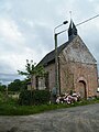 The church.
 North side.
 East side.
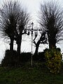 Calvary.
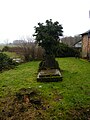 Cemetery.
 Water tower.
 Body of water.


See also
References
- "Répertoire national des élus: les maires". data.gouv.fr, Plateforme ouverte des données publiques françaises (in French). 9 August 2021.
- "Populations légales 2019". The National Institute of Statistics and Economic Studies. 29 December 2021.
- Population en historique depuis 1968, INSEE
Wikimedia Commons has media related to Épécamps.
На других языках
[de] Épécamps
Épécamps (picardisch: Épécamp) ist eine nordfranzösische Gemeinde mit 5 Einwohnern (Stand 1. Januar 2019) im Département Somme in der Region Hauts-de-France. Die Gemeinde liegt im Arrondissement Amiens, in der Communauté de communes du Bernavillois und im Kanton Doullens.- [en] Épécamps
Текст в блоке "Читать" взят с сайта "Википедия" и доступен по лицензии Creative Commons Attribution-ShareAlike; в отдельных случаях могут действовать дополнительные условия.
Другой контент может иметь иную лицензию. Перед использованием материалов сайта WikiSort.org внимательно изучите правила лицензирования конкретных элементов наполнения сайта.
Другой контент может иметь иную лицензию. Перед использованием материалов сайта WikiSort.org внимательно изучите правила лицензирования конкретных элементов наполнения сайта.
2019-2026
WikiSort.org - проект по пересортировке и дополнению контента Википедии
WikiSort.org - проект по пересортировке и дополнению контента Википедии