world.wikisort.org - France
Hornoy-le-Bourg (French pronunciation: [ɔʁnwa lə buʁ]) is a commune in the Somme department in Hauts-de-France in northern France.
Hornoy-le-Bourg | |
|---|---|
Commune | |
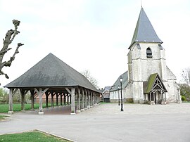
 The church and covered market in Hornoy-le-Bourg | |
 Coat of arms | |
Location of Hornoy-le-Bourg  | |
 Hornoy-le-Bourg  Hornoy-le-Bourg | |
| Coordinates: 49°50′46″N 1°54′08″E | |
| Country | France |
| Region | Hauts-de-France |
| Department | Somme |
| Arrondissement | Amiens |
| Canton | Poix-de-Picardie |
| Intercommunality | CC Somme Sud-Ouest |
| Government | |
| • Mayor (2020–2026) | James Froidure[1] |
| Area 1 | 51.23 km2 (19.78 sq mi) |
| Population | 1,681 |
| • Density | 33/km2 (85/sq mi) |
| Time zone | UTC+01:00 (CET) |
| • Summer (DST) | UTC+02:00 (CEST) |
| INSEE/Postal code | 80443 /80640 |
| Elevation | 68–201 m (223–659 ft) (avg. 166 m or 545 ft) |
| 1 French Land Register data, which excludes lakes, ponds, glaciers > 1 km2 (0.386 sq mi or 247 acres) and river estuaries. | |
Geography
The commune is situated at the junction of the D18 and D211 roads, some 16 miles (26 km) southwest of Amiens.
It is the second largest commune of the Somme department (by area).
Places of interest
- The church
- The market hall
- The war memorial
Population
| Year | Pop. | ±% p.a. |
|---|---|---|
| 1968 | 1,607 | — |
| 1975 | 1,503 | −0.95% |
| 1982 | 1,467 | −0.35% |
| 1990 | 1,448 | −0.16% |
| 1999 | 1,449 | +0.01% |
| 2007 | 1,663 | +1.74% |
| 2012 | 1,670 | +0.08% |
| 2017 | 1,679 | +0.11% |
| Source: INSEE[3] | ||

Personalities
- Countess of Dompierre d'Hornoy, Marquise of Florian, née Marie-Elisabeth Mignot, niece of Voltaire, was buried here in 1771.[4]
- Jean-Pierre Claris de Florian, poet, often stayed at Hornoy.
See also
References
- "Répertoire national des élus: les maires". data.gouv.fr, Plateforme ouverte des données publiques françaises (in French). 2 December 2020.
- "Populations légales 2019". The National Institute of Statistics and Economic Studies. 29 December 2021.
- Population en historique depuis 1968, INSEE
- Base Palissy: Monument funéraire de la comtesse de Dompierre d'Hornoy, marquise de Florian, Ministère français de la Culture. (in French)
Wikimedia Commons has media related to Hornoy-le-Bourg.
На других языках
[de] Hornoy-le-Bourg
Hornoy-le-Bourg ist eine französische Gemeinde mit 1681 Einwohnern (Stand 1. Januar 2019) im Département Somme in der Region Hauts-de-France. Sie gehört zum Arrondissement Amiens und zum Kanton Poix-de-Picardie.- [en] Hornoy-le-Bourg
[ru] Орнуа-ле-Бур
Орнуа-ле-Бур (фр. Hornoy-le-Bourg) — коммуна на севере Франции, регион О-де-Франс, департамент Сомма, округ Амьен, кантон Пуа-де-Пикарди. Расположена в 31 км к западу от Амьена и в 4 км от автомагистрали А29.Текст в блоке "Читать" взят с сайта "Википедия" и доступен по лицензии Creative Commons Attribution-ShareAlike; в отдельных случаях могут действовать дополнительные условия.
Другой контент может иметь иную лицензию. Перед использованием материалов сайта WikiSort.org внимательно изучите правила лицензирования конкретных элементов наполнения сайта.
Другой контент может иметь иную лицензию. Перед использованием материалов сайта WikiSort.org внимательно изучите правила лицензирования конкретных элементов наполнения сайта.
2019-2025
WikiSort.org - проект по пересортировке и дополнению контента Википедии
WikiSort.org - проект по пересортировке и дополнению контента Википедии