world.wikisort.org - Thailand
Pattani (Thai: ปัตตานี, pronounced [pàt.tāː.nīː]; Jawi: ڤطاني, 'ตานิง, pronounced [ˈtːaniŋ], Malay: Patani) is one of the southern provinces of Thailand. Neighboring provinces are (from southeast clockwise) Narathiwat, Yala, and Songkhla. Its capital is the town of Pattani.
This article needs additional citations for verification. (December 2020) |
Pattani
| |
|---|---|
Province | |
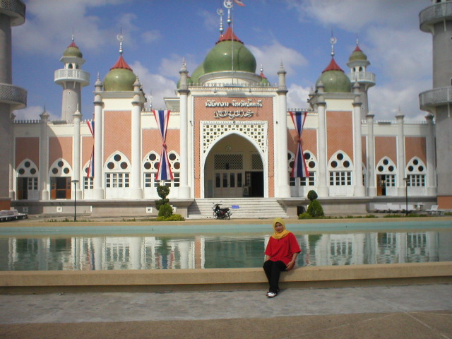 Pattani Grand Mosque | |
 Flag  Seal | |
 Map of Thailand highlighting Pattani province | |
| Country | Thailand |
| Capital | Pattani |
| Government | |
| • Governor | Niphan Boonluang (since 2021) |
| Area | |
| • Total | 1,940 km2 (750 sq mi) |
| • Rank | Ranked 68th |
| Population (2018)[2] | |
| • Total | 718,077 |
| • Rank | Ranked 37th |
| • Density | 370/km2 (1,000/sq mi) |
| • Rank | Ranked 9th |
| Human Achievement Index | |
| • HAI (2017) | 0.4950 "low" Ranked 74th |
| Time zone | UTC+7 (ICT) |
| Postal code | 94xxx |
| Calling code | 073 |
| ISO 3166 code | TH-94 |
| Website | www |
Geography
Pattani is on the Malay Peninsula, with the coast of the Gulf of Thailand to the north. The south is dominated by the Sankalakhiri mountain range, which includes Budo-Su-ngai Padi National Park, on the border with Yala and Narathiwat. The total forest area is 110 km2 (42 sq mi) or 5.6 percent of provincial area.[4]
Etymology
The name Pattani is the Thai adaptation of the Malay name Patani (Jawi: ڤتاني), which can mean "this beach" in Patani Malay language. (In standard Malay, this would be pantai ini.) According to legend, the founder of Patani went hunting and saw an albino mouse-deer the size of a goat, which then disappeared. He enquired where the animal had gone, and his men replied: "Pata ni lah!" ("this beach!") They searched for the mouse-deer but found instead an old man, who said his name was Che' Tani. The raja later ordered a town be built on the site where the mouse-deer had disappeared, and it is therefore believed that the town was named either after the beach or the old man.[5] Another suggestion is that it derives from a Sanskrit word pathini, meaning "virgin nymph"; Pathini was the name of a daughter of Merong Mahawangsa, founder of the preceding Langkasuka Empire.[6]
History
Historically, Pattani province was the centre of the Malay Sultanate of Patani Darul Makrif. For centuries a tributary state of Siam, Patani has been governed by Siam since its conquest in 1786. The provinces of Patani were turned into seven smaller provinces: Patani, Nhongchik, Raman, Ra-ngae, Saiburi, Yala and Yaring, later regrouped in 1906 into 4 larger provinces: Patani, Bangnara, Saiburi and Yala.[7] Siamese rule was officially acknowledged by the Burney Treaty of 1826 negotiated with the British Empire which included also Kedah, Kelantan, Perlis and Terengganu. Unlike these four sultanates, Patani was not included in the Anglo-Siamese Treaty of 1909 and remained under Siamese rule. Both Yala (Jala) and Narathiwat (Menara) were originally part of Patani, but were made provinces in their own right during the territorial administrative reform and the creation of a united centralized Siam state in the early-20th century.[citation needed]
Demographics
Pattani is one of the four provinces of Thailand where the majority of the population are Muslim, the others being Yala, Narathiwat, and Satun. In the 2014 census, Muslims made up roughly 88 percent of the population. This is mainly due to the people of Malay ancestry, and large portion of Pattani Malay speakers (though most speak Thai as well).
Symbols
The seal of the province shows the cannon called Phraya Tani, known as Sri Pattani in Malay, which was cast in Pattani province. It was brought to Bangkok in 1785, and is now on display in front of the Ministry of Defence in Bangkok.[citation needed]
The provincial flower is the Chinese hibiscus (Hibiscus rosa-sinensis), and the provincial tree is the Ironwood (Hopea odorata).[citation needed]
Administrative divisions
Provincial government
Pattani is divided into 12 districts (amphoe), which are further divided into 115 subdistricts (tambon) and 629 villages (muban).[citation needed] The districts of Chana (Malay: Chenok), Thepa (Malay:Tiba) and Saba Yoi (Malay:Sebayu) were detached from Pattani and transferred to Songkhla in 1796 by Siam government.[citation needed]
| Map | Number | Name | Thai | Jawi | Malay |
|---|---|---|---|---|---|
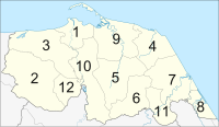 |
1 | Mueang Pattani | เมืองปัตตานี | فطاني | Patani |
| 2 | Khok Pho | โคกโพธิ์ | كوكفور | Kuk Pur | |
| 3 | Nong Chik | หนองจิก | نونغجيك | Nung Chik | |
| 4 | Panare | ปะนาเระ | فناريق | Penarik | |
| 5 | Mayo | มายอ | مايو | Mayu | |
| 6 | Thung Yang Daeng | ทุ่งยางแดง | |||
| 7 | Sai Buri | สายบุรี | سليندونغ بايو ، تلوبن | Selindung Bayu, Teluban | |
| 8 | Mai Kaen | ไม้แก่น | |||
| 9 | Yaring | ยะหริ่ง | جمبو | Jambu | |
| 10 | Yarang | ยะรัง | يا ليمو | Ya Li hu | |
| 11 | Kapho | กะพ้อ | |||
| 12 | Mae Lan | แม่ลาน |
Local government

As of 26 November 2019 there are:[9] one Pattani Provincial Administration Organisation (ongkan borihan suan changwat) and 17 municipal (thesaban) areas in the province. Pattani and Taluban have town (thesaban mueang) status. Further 15 subdistrict municipalities (thesaban tambon). The non-municipal areas are administered by 96 Subdistrict Administrative Organisations - SAO (ongkan borihan suan tambon).[2]
Economy
Six of Pattani's districts lie on the shore of the Gulf of Thailand. The number of fisheries workers in Pattani exceeds 80,000 as of 2019[update].[10] Pattani is the only province in Thailand where the agriculture ministry prohibits trawlers and destructive fishing nets within four nautical miles of the shoreline. Local fish stocks have rebounded as a result.[10]
Despite having many interesting places. But Pattani is the least visited province in the country according to data from Ministry of Tourism and Sports in 2018, the number of tourists is only 20,000–30,000 people, mostly Thai people.[11]
Transport
The Royal Thai Air Force's Pattani Airport is used for counter-insurgency operations in the area. It does not run public flights. Pattani's main railway stop is Pattani Railway Station.
Human achievement index 2017
| Health | Education | Employment | Income |
| 43 | 76 | 71 | 76 |
| Housing | Family | Transport | Participation |
 |
 |
||
| 20 | 58 | 61 | 61 |
| Province Pattani, with an HAI 2017 value of 0.4950 is "low", occupies place 74 in the ranking. | |||
Since 2003, United Nations Development Programme (UNDP) in Thailand has tracked progress on human development at sub-national level using the Human achievement index (HAI), a composite index covering all the eight key areas of human development. National Economic and Social Development Board (NESDB) has taken over this task since 2017.[3]
| Rank | Classification |
| 1 - 15 | "high" |
| 16 - 30 | "somewhat high" |
| 31 - 45 | "average" |
| 45 - 60 | "somewhat low" |
| 61 - 77 | "low" |
| Map with provinces and HAI 2017 rankings |
 |
Military rule
As of 2018[update], the provisions of Thailand's Internal Security Act remain imposed on Mae Lan District. Internal security restrictions, maintained by Thailand's Internal Security Operations Command can result in curfews, prohibited entry, or prohibited transport of goods. It is considered one step below the imposition of full martial law.[12]
Places of interest

Pattani has named as the land of three religions (Buddhism, Islam, Chinese religion).[13] There are important places of worship for all three religions:
- Wat Rat Burana (Thai: วัดราษฎร์บูรณะ), also known as Wat Chang Hai (Thai: วัดช้างให้), an ancient Thai Buddhist temple older than 300 years, a legendary monk Luang Pu Thuat was once the abbot of this place.
- Leng Chu Kiang Shrine (Thai: ศาลเจ้าเล่งจูเกียง) Chinese shrine of Lim Ko Niao (younger sister of Lin Daoqian) opposite Krue Se Mosque.
- Krue Se Mosque (Thai: มัสยิดกรือเซะ) Regarded as one of the more famous mosques with the oldest history.[13]
See also
- 2007 South Thailand bombings
- Pattani (region)
- South Thailand insurgency
References
- Advancing Human Development through the ASEAN Community, Thailand Human Development Report 2014, table 0:Basic Data (PDF) (Report). United Nations Development Programme (UNDP) Thailand. pp. 134–135. ISBN 978-974-680-368-7. Retrieved 17 January 2016, Data has been supplied by Land Development Department, Ministry of Agriculture and Cooperatives, at Wayback Machine.
{{cite report}}: CS1 maint: postscript (link)[dead link] - "รายงานสถิติจำนวนประชากรและบ้านประจำปี พ.ศ.2561" [Statistics, population and house statistics for the year 2018]. Registration Office Department of the Interior, Ministry of the Interior (in Thai). 31 December 2018. Retrieved 20 June 2019.
- Human achievement index 2017 by National Economic and Social Development Board (NESDB), pages 1-40, maps 1-9, retrieved 14 September 2019, ISBN 978-974-9769-33-1
- "ตารางที่ 2 พี้นที่ป่าไม้ แยกรายจังหวัด พ.ศ.2562" [Table 2 Forest area Separate province year 2019]. Royal Forest Department (in Thai). 2019. Retrieved 6 April 2021, information, Forest statistics Year 2019
{{cite web}}: CS1 maint: postscript (link) - Wyatt, David K. (December 1967). "A Thai Version of Newbold's "Hikayat Patani"". Journal of the Malaysian Branch of the Royal Asiatic Society. 40 (2 (212)): 16–37. JSTOR 41491922.
- "{ms} Sejarah Malaysia - Asal Usul nama Sungai Petani". Sejarahmalaysia.pnm.my. Archived from the original on 2013-06-03. Retrieved 2012-08-24.
- "A Brief Introduction to the Malay Kingdom of Patani". Islamic Human Rights Commission. 21 December 2004.
- Pattani : Selamat Datang Ke Pattani (PDF). Songkhla: IQ Media. 2018. p. 16.
- "Number of local government organizations by province". dla.go.th. Department of Local Administration (DLA). 26 November 2019. Retrieved 10 December 2019.
31 Pattani: 1 PAO, 2 Town mun., 15 Subdistrict mun., 96 SAO.
- Kongrut, Anchalee (2 September 2019). "From Pattani seas to Bangkok plates". Bangkok Post. Retrieved 7 September 2019.
- Laohavichai, Nakan (2019-01-11). "เมืองที่ไม่มีใครแล" [Town that nobody cares]. Posttoday (in Thai). Retrieved 2020-01-01.
- Raksaseri, Kornchanok (8 January 2018). "Isoc power boost 'not political'". Bangkok Post. Retrieved 8 January 2018.
- "สุขสุดใจ 'ปัตตานี' สัมผัสของดีในแดนใต้" [Happiness "Pattani" experience the good things in the southern land]. Manager Online (in Thai). 2016-03-07. Retrieved 2019-01-15.
External links
 Pattani travel guide from Wikivoyage
- Pattani province website (Thai)
- Tourism Authority of Thailand (TAT): Pattani
- Pattani Erupts Archived February 13, 2009, at the Wayback Machine
- Thailand Islamic Insurgency
- Muslim rebels light fuse in Thailand
Places adjacent to Pattani province | ||||||||||||||||
|---|---|---|---|---|---|---|---|---|---|---|---|---|---|---|---|---|
| ||||||||||||||||
Authority control | |
|---|---|
| General | |
| National libraries | |
| Other |
|
На других языках
[de] Pattani (Provinz)
Pattani (Thai: ปัตตานี) ist eine Provinz (Changwat) in der Südregion von Thailand. Die Hauptstadt der Provinz Pattani heißt ebenfalls Pattani.- [en] Pattani province
[ru] Паттани (провинция)
Паттани (тайск. ปัตตานี) — провинция на юге Таиланда. Граничит с провинциями: Яла, Наратхиват и Сонгкхла. Паттани расположена на полуострове Малакка, на севере омывается Сиамским заливом.Другой контент может иметь иную лицензию. Перед использованием материалов сайта WikiSort.org внимательно изучите правила лицензирования конкретных элементов наполнения сайта.
WikiSort.org - проект по пересортировке и дополнению контента Википедии