world.wikisort.org - Thailand
Chai Nat (Thai: ชัยนาท, pronounced [t͡ɕʰāj nâːt]) is one of the central provinces (changwat) of Thailand.[4] Neighbouring provinces are (from north clockwise) Nakhon Sawan, Sing Buri, Suphan Buri, and Uthai Thani. The town of Chai Nat is 188 km north of Bangkok.[5]
Chai Nat
ชัยนาท | |
|---|---|
Province | |
 Wat Pak Khlong Makham Thao | |
 Flag  Seal | |
| Motto(s): "หลวงปู่ศุขลือชา เขื่อนเจ้าพระยาลือชื่อ นามระบือสวนนก ส้มโอดกขาวแตงกวา" ("Reverend Grandfather Sukluecha, The famous Chao Phraya Dam, Known as Bird Park, Pomelo, white cucumber") | |
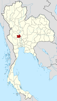 Map of Thailand highlighting Chai Nat province | |
| Country | Thailand |
| Capital | Chai Nat |
| Government | |
| • Governor | Rangsan Tancharoen (since October 2021) |
| Area | |
| • Total | 2,470 km2 (950 sq mi) |
| • Rank | Ranked 65th |
| Population (2018)[2] | |
| • Total | 328,263 |
| • Rank | Ranked 68th |
| • Density | 132.9/km2 (344/sq mi) |
| • Rank | Ranked 32nd |
| Human Achievement Index | |
| • HAI (2017) | 0.4840 "low" Ranked 75th |
| Time zone | UTC+7 (ICT) |
| Postal code | 17xxx |
| Calling code | 056 |
| ISO 3166 code | TH-18 |
Geography
Chai Nat is on the flat river plain of central Thailand's Chao Phraya River valley. In the south of the province the Chao Phraya Dam (formerly Chai Nat Dam) impounds the Chao Phraya River, both for flood control as well as to divert water into the country's largest irrigation system for the irrigation of rice paddies in the lower river valley. The dam, part of the Greater Chao Phraya Project, was finished in 1957 and was the first dam constructed in Thailand. The total forest area is 64 km2 (25 sq mi) or 2.6 percent of provincial area.[6]
History
Chai Nat was first established during the Ayutthaya period and was used as a successful base of operations for confronting the Burmese army. As the Burmese were defeated every time, the area earned the name Chai Nat, 'place of victory'.[4]
After World War II, when the Japanese had left, economic conditions were bad and food was in short supply. Chai Nat suffered this problem especially badly where bandits grouped up in the countryside stealing cattle and incited violence and crime.[7]
Symbols
The provincial seal shows a dhammachakka and in the background a mountain. It refers to the Dhammachak Buddha image housed in the wihaan of Wat Dhammamoen, built on the slope of a mountain.[8]
The provincial tree is the bael fruit tree (Aegle marmelos), and the provincial flower the Rainbow Shower tree (Cassia javanica). Bleeker's sheatfish (Phalacronotus bleekeri) is a provincial fish.
The slogan of the province is "Venerable Luang Pu Suk, renowned Chao Phraya Dam, famous bird park and tasty khao taengkwa pomelo".
Administrative divisions
Provincial government
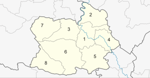
Chai Nat is divided into eight districts (amphoes). The districts are further subdivided into 53 sub-districts (tambons) and 503 villages (mubans).

Local government
As of 26 November 2019 there are:[9] one Chai Nat Provincial Administrative Organization - PAO (ongkan borihan suan changwat) and 39 municipal (thesaban) areas in the province. Chai Nat has town (thesaban mueang) status. Further 38 subdistrict municipalities (thesaban tambon).[2] The non-municipal areas are administered by 20 Subdistrict Administrative Organizations - SAO (ongkan borihan suan tambon).
Places
Apart from Chao Phraya Dam, Chai Nat also has various important places such as
- Chai Nat Bird Park: is a largest bird park in Chai Nat and Thailand, covering the area of 248 rai, include the largest aviary in Asia, and release the birds living in nature. Besides, there is also a public aquarium displaying freshwater fish species found in the Chao Phraya River.
- Wat Pak Khlong Makham Thao: a Thai temple in Wat Sing District, next to the mouth of Khlong Makham Thao (Tha Chin River). This temple used to be the residence of Luang Pu Suk. He was a monk who was known for being a magician monk and producer of many renowned amulets. He has many disciples and most respected, one of which was a Prince Abhakara Kiartivongse, Prince of Chumphon.
- Sapphaya Old Police Station: an ancient police station of district of Sapphaya, built since the King Rama V's reign older than 100 years. The station features a single level wooden building with a hip roof and received the ASA Architectural Conservation Award in 2018.
- Chai Nat Provincial Stadium, also known as Khao Plong Stadium: is a Chai Nat Provincial Stadium and the home stadium of Chainat Hornbill F.C.
Notable people
Born in Chai Nat
- Pumpuang Duangjan (b. 1961–1992): Luk thung singer
- Kapol Thongplub (b. 1967): DJ, TV host
- Muangchai Kittikasem (b. 1968): world-class professional boxer
Human achievement index 2017
| Health | Education | Employment | Income |
| 60 | 62 | 75 | 69 |
| Housing | Family | Transport | Participation |
 |
 |
||
| 75 | 63 | 34 | 25 |
| Province Chai Nat, with an HAI 2017 value of 0.4840 is "low", occupies place 75 in the ranking. | |||
Since 2003, United Nations Development Programme (UNDP) in Thailand has tracked progress on human development at sub-national level using the Human achievement index (HAI), a composite index covering all the eight key areas of human development. National Economic and Social Development Board (NESDB) has taken over this task since 2017.[3]
| Rank | Classification |
| 1 - 15 | "high" |
| 16 - 30 | "somewhat high" |
| 31 - 45 | "average" |
| 45 - 60 | "somewhat low" |
| 61 - 77 | "low" |
| Map with provinces and HAI 2017 rankings |
 |
References
- Advancing Human Development through the ASEAN Community, Thailand Human Development Report 2014, table 0:Basic Data (PDF) (Report). United Nations Development Programme (UNDP) Thailand. pp. 134–135. ISBN 978-974-680-368-7. Retrieved 17 January 2016, Data has been supplied by Land Development Department, Ministry of Agriculture and Cooperatives, at Wayback Machine.
{{cite report}}: CS1 maint: postscript (link)[dead link] - "ร่ยงานสถิติจำนวนประชากรและบ้านประจำปี พ.ศ.2561" [Statistics, population and house statistics for the year 2018]. Registration Office Department of the Interior, Ministry of the Interior. stat.bora.dopa.go.th (in Thai). 31 December 2018. Archived from the original on 2 April 2019. Retrieved 20 June 2019.
- Human achievement index 2017 by National Economic and Social Development Board (NESDB), pages 1-40, maps 1-9, retrieved 14 September 2019, ISBN 978-974-9769-33-1
- "About Chainat". Tourism Authority of Thailand (TAT). Archived from the original on 22 April 2019. Retrieved 29 May 2015.
- "Distance: Bangkok to Chai Nat". Google Maps. Retrieved 29 May 2015.
- "ตารางที่ 2 พี้นที่ป่าไม้ แยกรายจังหวัด พ.ศ.2562" [Table 2 Forest area Separate province year 2019]. Royal Forest Department (in Thai). 2019. Retrieved 6 April 2021, information, Forest statistics Year 2019
{{cite web}}: CS1 maint: postscript (link) - Reynolds, Craig J. (2019-10-22). Power, Protection and Magic in Thailand: The Cosmos of a Southern Policeman. ANU Press. p. 50. ISBN 978-1-76046-317-5.
- "Chainat". THAILEX Travel Encyclopedia. Archived from the original on 29 May 2015. Retrieved 29 May 2015.
- "Number of local government organizations by province". dla.go.th. Department of Local Administration (DLA). 26 November 2019. Retrieved 10 December 2019.
9 Chai Nat: 1 PAO, 1 Town mun., 38 Subdistrict mun., 20 SAO.
External links
 Chai Nat travel guide from Wikivoyage
- Chainat Bird Park
- Website of province (Thai only)
- Chainat provincial map, coat of arms and postal stamp
Places adjacent to Chai Nat province | ||||||||||||||||
|---|---|---|---|---|---|---|---|---|---|---|---|---|---|---|---|---|
| ||||||||||||||||
Authority control | |
|---|---|
| General | |
| National libraries | |
| Other | |
На других языках
[de] Chai Nat (Provinz)
Chai Nat (auch als Chainat wiedergegeben; Thai: ชัยนาท, Aussprache: .mw-parser-output .IPA a{text-decoration:none}[t͡ɕʰaj nâːt]; übersetzt etwa: „Ort des Sieges“) ist eine Provinz (Changwat) in der Zentralregion von Thailand.- [en] Chai Nat province
Другой контент может иметь иную лицензию. Перед использованием материалов сайта WikiSort.org внимательно изучите правила лицензирования конкретных элементов наполнения сайта.
WikiSort.org - проект по пересортировке и дополнению контента Википедии