world.wikisort.org - Thailand
Phichit (Thai: พิจิตร, pronounced [pʰí(ʔ).t͡ɕìt], lit. 'beautiful') is one of Thailand's seventy-six provinces (changwat) lies in lower northern Thailand and 330 km due north of Bangkok. Neighbouring provinces are (from north clockwise) Phitsanulok, Phetchabun, Nakhon Sawan, and Kamphaeng Phet.
Phichit
พิจิตร | |
|---|---|
Province | |
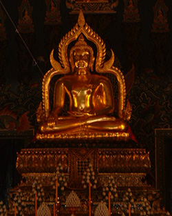
 Wat Pho Prathap Chang, an ancient temple in Pho Prathap Chang district, believed to be the birthplace of the Luang Sorasak who later became a King of Ayutthaya | |
 Flag  Seal | |
 Map of Thailand highlighting Phichit province | |
| Country | Thailand |
| Capital | Phichit |
| Government | |
| • Governor | Paiboon Nabutchom (since October 2021) |
| Area | |
| • Total | 4,319 km2 (1,668 sq mi) |
| • Rank | Ranked 51st |
| Population (2019)[2] | |
| • Total | 536,311 |
| • Rank | Ranked 50th |
| • Density | 124/km2 (320/sq mi) |
| • Rank | Ranked 38th |
| Human Achievement Index | |
| • HAI (2017) | 0.5705 "somewhat low" Ranked 54th |
| Time zone | UTC+7 (ICT) |
| Postal code | 66xxx |
| Calling code | 055 & 056 |
| ISO 3166 code | TH-66 |
| Vehicle registration | พิจิตร |
| Website | www |
Geography
The Nan and Yom Rivers flow through Phichit province, joining shortly before the Chao Phraya is formed. The province mainly consists of low fertile river plains, making rice and lotus the main crops.[4] The total forest area is just 17 km2 (6.6 sq mi) or 0.4 percent of provincial area.[1]
History
The town of Phichit was established in 1058 by Phraya Kotabongthevaraja (พระยาโคตระบอง), and was first part of the Sukhothai Kingdom, and later of Ayutthaya. An old temple in Pho Prathap Chang District is Wat Pho Prathap Chang (วัดโพธิ์ประทับช้าง). It was built by Phra Chao Suea, an Ayutthaya king, in 1701 at a site reputed to be his birthplace. The site is surrounded by double-walls and huge trees, some of which are over 200 years old.[5]
The name of the main city changed several times. At first it was called Sa Luang ('city of the royal pond'). In Ayutthaya times it was called Okhaburi ('city in the swamp'), and then finally Phichit ('beautiful city').
Symbols
The provincial seal shows a pond, which refers to the old name of Phichit, Mueang Sa Luang ('city of the royal pond'). The banyan tree in front refers to Wat Pho Prathap Chang. The temple was built in 1669–1671 by King Luang Sorasak, who was born in the village of Pho Prathap Chang, between a banyan and a sacred fig.
The flag of Phichit shows the circular provincial seal in the middle. It has three green bars and two white horizontal bars, with the middle bar being interrupted by the seal.
The provincial tree is the ironwood. The provincial flower is the lotus.
The provincial motto (loosely translated) states as follows:
- The province of Chalawan the crocodile king, the fun and exciting annual boat race, the land of exquisite rice and the delicious Tha Khoi pomelo; the center of the province is the Luang Pho Phet.
Health
The main hospital in Phichit is Phichit Hospital, operated by the Ministry of Public Health.
Transport
Rail
Phichit main station is Phichit railway station.
Administrative divisions

The province is divided into 12 districts (amphoes). These are further divided into 89 subdistricts (tambons) and 852 villages (mubans).
|
|
Local government
As of 26 November 2019 there are:[6] one Phichit Provincial Administration Organisation (ongkan borihan suan changwat) and 28 municipal (thesaban) areas in the province. Phichit, Taphan Hin and Bang Mun Nak have town (thesaban mueang) status. There are a further 25 subdistrict municipalities (thesaban tambon). The non-municipal areas are administered by 73 Subdistrict Administrative Organisations (SAO) (ongkan borihan suan tambon).[2]
Human achievement index 2017
| Health | Education | Employment | Income |
| 53 | 53 | 48 | 18 |
| Housing | Family | Transport | Participation |
 |
 |
||
| 30 | 41 | 53 | 59 |
| Province Phichit, with an HAI 2017 value of 0.5705 is "somewhat low", occupies place 54 in the ranking. | |||
Since 2003, United Nations Development Programme (UNDP) in Thailand has tracked progress on human development at sub-national level using the Human achievement index (HAI), a composite index covering all the eight key areas of human development. National Economic and Social Development Board (NESDB) has taken over this task since 2017.[3]
| Rank | Classification |
| 1 - 15 | "high" |
| 16 - 30 | "somewhat high" |
| 31 - 45 | "average" |
| 45 - 60 | "somewhat low" |
| 61 - 77 | "low" |
| Map with provinces and HAI 2017 rankings |
 |
Notable people
- Suriyenthrathibodi: 29th King of Ayutthaya
- Sanan Kachornprasart: politician
- Yodrak Salakjai: luk thung singer
- Santi Duangsawang: luk thung singer
- Busaba Athisthan: luk thung singer
- Chuchart Trairatanapradit: professional snooker player
- Den Junlaphan, also known as Eagle Kyowa: professional boxer
- Jirayu Tangsrisuk (James): actor, singer, model
References
- "ตารางที่ 2 พี้นที่ป่าไม้ แยกรายจังหวัด พ.ศ.2562" [Table 2 Forest area Separate province year 2019]. Royal Forest Department (in Thai). 2019. Retrieved 6 April 2021, information, Forest statistics Year 2019, Thailand boundary from Department of Provincial Administration in 2013
{{cite web}}: CS1 maint: postscript (link) - รายงานสถิติจำนวนประชากรและบ้านประจำปี พ.ส.2562 [Statistics, population and house statistics for the year 2019]. Registration Office Department of the Interior, Ministry of the Interior. stat.bora.dopa.go.th (in Thai). 31 December 2019. Retrieved 26 February 2020.
- Human achievement index 2017 by National Economic and Social Development Board (NESDB), pages 1-40, maps 1-9, retrieved 14 September 2019, ISBN 978-974-9769-33-1
- "Phichit: General Info". Tourism Authority of Thailand (TAT). Archived from the original on 25 March 2016. Retrieved 4 April 2016.
- "WAT PHO PRATHAP CHANG". Tourism Authority of Thailand (TAT). Retrieved 4 April 2016.
- "Number of local government organizations by province". dla.go.th. Department of Local Administration (DLA). 26 November 2019. Retrieved 10 December 2019.
35 Phichit: 1 PAO, 3 Town mun., 25 Subdistrict mun., 73 SAO.
External links
 Phichit travel guide from Wikivoyage
- Provincial website
- Phichit provincial map, coat of arms, and postal stamp
Places adjacent to Phichit province | ||||||||||||||||
|---|---|---|---|---|---|---|---|---|---|---|---|---|---|---|---|---|
| ||||||||||||||||
Authority control | |
|---|---|
| General | |
| National libraries | |
| Other | |
На других языках
[de] Phichit (Provinz)
Phichit (Thai: พิจิตร) ist eine Provinz (Changwat) in der Nordregion von Thailand. Die Hauptstadt der Provinz Phichit heißt ebenfalls Phichit.- [en] Phichit province
Другой контент может иметь иную лицензию. Перед использованием материалов сайта WikiSort.org внимательно изучите правила лицензирования конкретных элементов наполнения сайта.
WikiSort.org - проект по пересортировке и дополнению контента Википедии