world.wikisort.org - Thailand
Surat Thani (Thai: สุราษฎร์ธานี, pronounced [sù.râːt tʰāː.nīː]), often shortened to Surat, is the largest of the southern provinces (changwat) of Thailand. It lies on the western shore of the Gulf of Thailand. Surat Thani means 'city of good people', a title given to the city by King Vajiravudh (Rama VI); Surat Thani is therefore the sole province in Southern Thailand for which the native name is in the Central Thai language.
This article is written like a travel guide rather than an encyclopedic description of the subject. (November 2019) |
Surat Thani
สุราษฎร์ธานี | |
|---|---|
Province | |
 Khao Sok National Park | |
 Flag  Seal | |
| Nickname: Surat | |
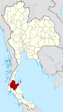 Map of Thailand highlighting Surat Thani province | |
| Country | Thailand |
| Capital | Surat Thani |
| Government | |
| • Governor | Witchawut Jinto (since 2017) |
| Area | |
| • Total | 12,891 km2 (4,977 sq mi) |
| • Rank | Ranked 6th |
| Population (2018)[2] | |
| • Total | 1,063,501 |
| • Rank | Ranked 21st |
| • Density | 83/km2 (210/sq mi) |
| • Rank | Ranked 59th |
| Human Achievement Index | |
| • HAI (2017) | 0.5476 "low" Ranked 65th |
| Time zone | UTC+7 (ICT) |
| Postal code | 84xxx |
| Calling code | 077 |
| ISO 3166 code | TH-84 |
| Website | www |
Geography
Neighbouring provinces are (from north, clockwise) Chumphon, Nakhon Si Thammarat, Krabi, Phang Nga, and Ranong.
Geographically, the centre of the province is the coastal plain of the Tapi River, mostly grassland interspersed with rubber trees and coconut plantations. In the west are the limestone mountains of the Phuket range which are mostly covered with forest. Khao Sok National Park is found there. To the east the hills of the Nakhon Si Thammarat (or Bantat) mountain range start to rise, protected in the Tai Rom Yen National Park. The total forest area is 3,764 km2 (1,453 sq mi) or 28.8 percent of provincial area.[4]
Many islands in the Gulf of Thailand belong to the district, including the tourist islands Ko Samui, Ko Pha Ngan and Ko Tao, as well as the Ko Ang Thong Marine National Park.
The main rivers of Surat Thani province are the Tapi River and the Phum Duang River, which join at the town Tha Kham shortly before they flow into Bandon Bay. The delta of these rivers, locally known as Nai Bang (ในบาง), is directly north of the city of Surat Thani. It consists of several channels with small islands mostly covered by mangroves and orchards.
Other protected areas in the province are the Khlong Phanom and Kaeng Krung National Park, Than Sadet-Ko Pha Ngan Marine National Park, the non-hunting areas Khao Tha Phet and Nong Thung Thong and the wildlife sanctuaries Khlong Phraya, Khlong Saeng, and Khlong Yan. The Hat Khanom - Mu Ko Thale Tai, which has a few small islands south of Ko Samui, is currently being created.
History
The area of Surat Thani was already inhabited in prehistoric times by Semang and Malayan tribes. Founded in the 3rd century, the Srivijaya kingdom dominated the Malay Peninsula until the 13th century. The city of Chaiya contains ruins from the Srivijaya period, and it was probably a regional capital of the kingdom. Some Thai historians even argue that it was the kingdom's capital for a time, but this is disputed. Wiang Sa was another important settlement of the time.

After the fall of the Srivijaya, the area was divided into the cities (mueang) of Chaiya, Thatong (now Kanchanadit), and Khirirat Nikhom. Chaiya was administered directly from the Thai capital, while Thatong and Khirirat were controlled by the Nakhon Si Thammarat Kingdom. In 1899, they were all merged into a single province called Chaiya. In 1915, the court of the Monthon Chumphon was transferred to Bandon, which received the new name of Surat Thani on 29 July 1915, during a visit of King Vajiravudh (Rama VI). This was likely influenced by the major port city of Surat in Gujarat, India. The monthon was also renamed Surat. In 1926 it was abolished and incorporated into monthon Nakhon Si Thammarat. The monthon was dissolved in 1933, and the province became a first level administrative subdivision.

The provincial administration was in a building in Tha Kham (Phunphin District). Shortly before World War II, it was moved to the city of Surat Thani, on the banks of the Tapi River, which is named after the Tapi River in Surat, located southern of Gujarat, India. When the Japanese invaded Thailand on 8 December 1941, the administrative building was destroyed during the battle for the city. It was rebuilt in 1954, but on 19 March 1982, a bomb planted by communist rebels blew up the building, killing five people. The third and present building was relocated to the south of the city, and the former site of the provincial hall is now the site of the city pillar shrine (Lak Mueang).
Symbols
The seal of the province shows the pagoda of Wat Phra Borommathat Chaiya, which is believed to have been built 1,200 years ago.[5] The flag of the province shows the pagoda in middle, placed on a horizontally split flag with orange on top and yellow on the bottom.
The provincial flower is the bua phut (Rafflesia kerrii), a parasitic plant with one of the biggest flowers of all plants. The provincial tree is the ton kiam (Cotylelobium melanoxylon).
The provincial slogan is "เมืองร้อยเกาะ เงาะอร่อย หอยใหญ่ ไข่แดง แหล่งธรรมะ" (Mueang roi ko, ngo aroi, hoi yai, khai daeng, laeng thamma), which translates to "city of 100 islands, delicious rambutan, big shells, red eggs, the center of Buddhism". "Red eggs" refers to a local culinary specialty of salted duck egg, while the "big shells" refers to abundant oyster available. "Center of Buddhism" refers to the Wat Phra Borommathat Chaiya and Suan Mokkhaphalaram.
Administrative divisions

Provincial government
The province is divided into 19 districts (amphoes), which are further divided into 131 subdistricts (tambons) and 1,028 villages (mubans).
|
|
Local government
As of 26 November 2019 there are:[6] one Surat Thani Provincial Administration Organisation (ongkan borihan suan changwat) and 40 municipal (thesaban) areas in the province. Surat Thani and Ko Samui have city (thesaban nakhon) status. Tha Kham, Na San and Don Sak have town (thesaban mueang) status. Further 35 subdistrict municipalities (thesaban tambon). The non-municipal areas are administered by 97 Subdistrict Administrative Organisations - SAO (ongkan borihan suan tambon).[2]
| No. | City | Thai | Population | Notes |
|---|---|---|---|---|
| 1. | Surat Thani | เทศบาลนครสุราษฎร์ธานี | 127,550 | Provincial capital, main bus station |
| 2. | Ko Samui | เทศบาลเมืองเกาะสมุย | 52,510 | Tourism |
| 3. | Tha Kham | เทศบาลเมืองท่าข้าม | 20,363 | Main railway station, airport |
| 4. | Na San | เทศบาลเมืองนาสาร | 19,851 | |
| 5. | Talat Chaiya | เทศบาลตำบลตลาดไชยา | 12,955 | Historic town |
| 6. | Don Sak | เทศบาลตำบลดอนสัก | 11,357 | Main port |
| 7. | Ko Pha Ngan | เทศบาลตำบลเกาะพะงัน | 3,357 | Tourism |
For national elections, the province is divided into two constituencies, each eligible to elect three members of parliament.
Economy
In the 2008 census, the province had a GPP of 132,637.3 million baht (US$4,019.31 million) and GPP per capita of 134,427 (US$4,073.54)[citation needed] compared with a GPP of 122,398 million baht (US$3,599.94 million) and GPP per capita of 125,651 baht (US$3,695.62) in the 2007 census, with a GPP growth rate of 8.37 percent and per capita growth rate of 6.98 percent.
The main agricultural products of the province are coconut and rambutan. The coconuts are often picked from the tree by specially trained monkeys, mostly pig-tailed macaques (Macaca nemestrina). The monkey school of the late Somporn Saekhow is the most known training centre. Rambutan trees were first planted in Surat Thani in 1926 by the Chinese Malay Mr. K. Vong in Ban Na San District. An annual rambutan fair is held in early-August and includes a parade of highly decorated floats on the Tapi River. Rubber tree plantations are also common in the province.
A notable local product is the hand-woven silk cloth from the coastal village Phum Riang in Chaiya District. Chaiya is also the most famous source of red eggs, a local specialty. Ducks are fed with crabs and fish and the eggs are then preserved by placing them in a soil-salt mixture.
Tourism is the major source of provincial income. The province earned 64 billion baht from tourism in 2018. That revenue accounted for 63 percent of Surat Thani's overall tourism income, most of it attributable to its island attractions: Ko Samui, Ko Pha Ngan, Ko Tao, and Mu Ko Ang Thong National Park.[7]
Human achievement index 2017
| Health | Education | Employment | Income |
| 28 | 50 | 59 | 15 |
| Housing | Family | Transport | Participation |
 |
 |
||
| 73 | 37 | 30 | 70 |
| Province Surat Thani, with an HAI 2017 value of 0.5476 is "low", occupies place 65 in the ranking. | |||
Since 2003, United Nations Development Programme (UNDP) in Thailand has tracked progress on human development at sub-national level using the Human achievement index (HAI), a composite index covering all the eight key areas of human development. National Economic and Social Development Board (NESDB) has taken over this task since 2017.[3]
| Rank | Classification |
| 1 - 15 | "high" |
| 16 - 30 | "somewhat high" |
| 31 - 45 | "average" |
| 45 - 60 | "somewhat low" |
| 61 - 77 | "low" |
| Map with provinces and HAI 2017 rankings |
 |
National parks
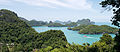
- Mu Ko Ang Thong National Park is a marine national park in the Gulf of Thailand.[8] It covers 42 islands and a total area of 102 km2, of which about 50 km2 are land and the rest is water. The park was established on 12 November 1980.[9] The northern tip of Ko Phaluai is also part of the marine park. There is a ranger station, bungalows, a shop, and a restaurant at Ao Phi Beach on Ko Wua Talap.
- Khao Sok National Park is the largest area of virgin forest in southern Thailand and is a remnant of rain forest which is older and more diverse than the Amazon rain forest.
Gallery
 Ang Thong National Park from Ko Wua Ta Lap Island
 Khlong Phanom National Park
 Primary tropical rainforest around Cheow Lan Lake
 The shore of Cheow Lan Lake
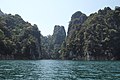 Limestone rock formations on Cheow Lan Lake
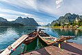 Khao Sok National Park
 Khao Sok National Park
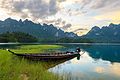 Khao Sok National Park
 Khao Sok National Park
 Cheow Lan Lake
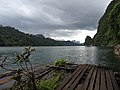 Cheow Lan Lake
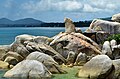 Hin Ta Hin Yai, Ko Samui
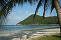 Ao Thong Nai Pan Yai, Ko Pha-Ngan
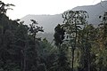 Khao Sok tropical rainforest
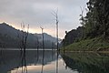 Cheow Lan Lake
 Karst formations, Cheow Lan Lake
 Trees rising out of Cheow Lan Lake
 City pillar shrine, Surat Thani
 Beach at Ko Mae Ko


References
- Advancing Human Development through the ASEAN Community, Thailand Human Development Report 2014, table 0:Basic Data (PDF) (Report). United Nations Development Programme (UNDP) Thailand. pp. 134–135. ISBN 978-974-680-368-7. Retrieved 17 January 2016, Data has been supplied by Land Development Department, Ministry of Agriculture and Cooperatives, at Wayback Machine.
{{cite report}}: CS1 maint: postscript (link)[dead link] - "รายงานสถิติจำนวนประชากรและบ้านประจำปี พ.ศ.2561" [Statistics, population and house statistics for the year 2018]. Registration Office Department of the Interior, Ministry of the Interior (in Thai). 31 December 2018. Archived from the original on 14 June 2019. Retrieved 20 June 2019.
- [[:File:Human achievement index 2017.pdf|Human achievement index 2017 by National Economic and Social Development Board (NESDB), pages 1-40, maps 1-9, retrieved 14 September 2019, ISBN 978-974-9769-33-1]][failed verification]
- "ตารางที่ 2 พี้นที่ป่าไม้ แยกรายจังหวัด พ.ศ.2562" [Table 2 Forest area Separate province year 2019]. Royal Forest Department (in Thai). 2019. Retrieved 6 April 2021, information, Forest statistics Year 2019
{{cite web}}: CS1 maint: postscript (link) - "Wat Phra Borommathat Chaiya Ratcha Worawihan, Surat Thani province". Thailand Tourism Directory. Retrieved 28 November 2019.
- "Number of local government organizations by province". dla.go.th. Department of Local Administration (DLA). 26 November 2019. Retrieved 10 December 2019.
67 Surat Thani: 1 PAO, 2 City mun., 3 Town mun., 35 Subdistrict mun., 97 SAO.
- "18km Samui bridge urged". Bangkok Post. 3 February 2020. Retrieved 3 February 2020.
- "MU KO ANG THONG NATIONAL PARK". Tourism Authority of Thailand (TAT). Archived from the original on 30 June 2019. Retrieved 2 January 2018.
- "Mu Ko Ang Thong National Park". Department of National Parks (DNP). Archived from the original on 11 November 2006. Retrieved 2 January 2018.
External links
 Surat Thani travel guide from Wikivoyage
- Province page from the Tourist Authority of Thailand
- Official website (in Thai)
- Surat Thani provincial map, coat of arms and postal stamp
Places adjacent to Surat Thani province | |
|---|---|
Authority control | |
|---|---|
| General | |
| National libraries | |
| Other | |
На других языках
[de] Surat Thani (Provinz)
Surat Thani (Thai สุราษฎร์ธานี) ist eine Provinz (Changwat) in der Südregion von Thailand. Die Hauptstadt der Provinz heißt ebenfalls Surat Thani.- [en] Surat Thani province
[ru] Сураттхани (провинция)
Сура́ттха́ни[1] (тайск. สุราษฎร์ธานี) — самая большая по площади провинция южного Таиланда. Название провинции и её одноименной столицы означает «город хороших людей».Другой контент может иметь иную лицензию. Перед использованием материалов сайта WikiSort.org внимательно изучите правила лицензирования конкретных элементов наполнения сайта.
WikiSort.org - проект по пересортировке и дополнению контента Википедии