world.wikisort.org - France
Rosières-en-Santerre (French pronunciation: [ʁozjɛʁ ɑ̃ sɑ̃tɛʁ], literally Rosières in Santerre) is a commune in the Somme department in Hauts-de-France in northern France.
Rosières-en-Santerre | |
|---|---|
Commune | |
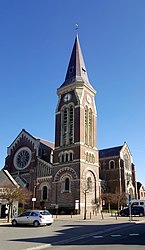
 The church in Rosières-en-Santerre | |
 Coat of arms | |
Location of Rosières-en-Santerre  | |
 Rosières-en-Santerre  Rosières-en-Santerre | |
| Coordinates: 49°48′54″N 2°42′11″E | |
| Country | France |
| Region | Hauts-de-France |
| Department | Somme |
| Arrondissement | Péronne |
| Canton | Moreuil |
| Intercommunality | CC Terre de Picardie |
| Government | |
| • Mayor (2020–2026) | Françoise Maille-Barbare |
| Area 1 | 12.98 km2 (5.01 sq mi) |
| Population | 3,017 |
| • Density | 230/km2 (600/sq mi) |
| Time zone | UTC+01:00 (CET) |
| • Summer (DST) | UTC+02:00 (CEST) |
| INSEE/Postal code | 80680 /80170 |
| Elevation | 70–106 m (230–348 ft) (avg. 91 m or 299 ft) |
| 1 French Land Register data, which excludes lakes, ponds, glaciers > 1 km2 (0.386 sq mi or 247 acres) and river estuaries. | |
Geography
The commune is situated some 20 kilometres (12 mi) southeast of Amiens, at the junction of the D28 and D329 roads. Rosières station has rail connections to Amiens and Laon.
Population
| Year | Pop. | ±% p.a. |
|---|---|---|
| 1968 | 2,605 | — |
| 1975 | 2,815 | +1.11% |
| 1982 | 2,985 | +0.84% |
| 1990 | 3,107 | +0.50% |
| 1999 | 2,956 | −0.55% |
| 2007 | 2,877 | −0.34% |
| 2012 | 2,985 | +0.74% |
| 2017 | 3,008 | +0.15% |
| Source: INSEE[2] | ||
Places of interest

- The mairie
- The church
Twin towns
![]() Drochtersen, Germany since 1972
Drochtersen, Germany since 1972
See also
References
- "Populations légales 2019". The National Institute of Statistics and Economic Studies. 29 December 2021.
- Population en historique depuis 1968, INSEE
External links
Wikimedia Commons has media related to Rosières-en-Santerre.
- Rosières-en-Santerre – Official website (in French)
На других языках
[de] Rosières-en-Santerre
Rosières-en-Santerre (picardisch: Rousière-in-Santérre) ist eine nordfranzösische Gemeinde mit 3017 Einwohnern (Stand 1. Januar 2019) im Département Somme in der Region Hauts-de-France. Die Gemeinde liegt im Arrondissement Péronne und gehört zum Kanton Moreuil und ist Teil der Communauté de communes Terre de Picardie.- [en] Rosières-en-Santerre
[es] Rosières-en-Santerre
Rosières-en-Santerre es una población y comuna francesa, en la región de Picardía, departamento de Somme, en el distrito de Montdidier. Es el chef-lieu y mayor población del cantón de Rosières-en-Santerre.[ru] Розьер-ан-Сантер
Розьер-ан-Сантер (фр. Rosières-en-Santerre) — коммуна на севере Франции, регион О-де-Франс, департамент Сомма, округ Перон, кантон Морёй. Расположена в 32 км к юго-востоку от Амьена и в 10 км от пересечения автомагистралей А29 и А1 "Нор". На севере коммуны находится железнодорожная станция Розьер-ан-Сантер линии Амьен-Лан.Текст в блоке "Читать" взят с сайта "Википедия" и доступен по лицензии Creative Commons Attribution-ShareAlike; в отдельных случаях могут действовать дополнительные условия.
Другой контент может иметь иную лицензию. Перед использованием материалов сайта WikiSort.org внимательно изучите правила лицензирования конкретных элементов наполнения сайта.
Другой контент может иметь иную лицензию. Перед использованием материалов сайта WikiSort.org внимательно изучите правила лицензирования конкретных элементов наполнения сайта.
2019-2025
WikiSort.org - проект по пересортировке и дополнению контента Википедии
WikiSort.org - проект по пересортировке и дополнению контента Википедии