world.wikisort.org - China
Yanqi Hui Autonomous County (Uyghur: Qarasheher, Karashahr) is an autonomous county in the Xinjiang Uyghur Autonomous Region and is under the administration of the Bayin'gholin Mongol Autonomous Prefecture. It has an area of 2,429 km2 (938 sq mi). According to the 2002 census, it has a population of 120,000. The Qigexing Buddhist Temple Ruins are located in Yanqi County, about 25–30 km (16–19 mi) southwest of the town of Yanqi.
Yanqi Hui Autonomous County
Kara Shahr; Yenki | |
|---|---|
County | |
 Mosque in the city center of Yanqi | |
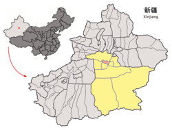 Yanqi County (red) within Bayin'gholin Prefecture (yellow) and Xinjiang | |
 Yanqi Location of the seat in Xinjiang | |
| Coordinates: 42°03′35″N 86°34′27″E | |
| Country | People's Republic of China |
| Autonomous region | Xinjiang |
| Autonomous prefecture | Bayin'gholin Mongol Autonomous Prefecture |
| Time zone | UTC+8 (China Standard) |
| Yanqi Hui Autonomous County | |||||||||||
|---|---|---|---|---|---|---|---|---|---|---|---|
 | |||||||||||
| Chinese name | |||||||||||
| Simplified Chinese | 焉耆回族自治县 | ||||||||||
| Traditional Chinese | 焉耆回族自治縣 | ||||||||||
| |||||||||||
| Uyghur name | |||||||||||
| Uyghur | يەنجى خۇيزۇ ئاپتونوم ناھىيىسى | ||||||||||
| |||||||||||
Administrative division
The autonomous county contains four towns and four townships:[citation needed]
Towns:
- Yanqi Town (焉耆镇; Yānqí Zhèn / قاراشەھەر بازىرى), consisting of ten residential communities (社区; shèqū) and one village, seat of the county government, 29.000 inhabitants (2000);
- Qigxin (七个星镇; Qīgèxīng Zhèn / شىگشىن بازىرى), one residential community and nine villages, 12.629 inhabitants (2000);
- Yongning (永宁镇; Yǒngníng Zhèn / يۇڭنىڭ بازىرى), two residential communities and eight villages, 18.235 inhabitants (2000);
- Sishilichengzi (四十里城子镇; Sìshílǐchéngzi Zhèn / دەنزىل بازىرى), one residential community and five villages, 8.722 inhabitants (2000);
Townships:
- Beidaqu (北大渠乡; Běidàqú Xiāng; 'Northern Great Canal Village' / بېيداچا يېزىسى), six villages, 9.026 inhabitants (2000);
- Wuhaoqu (五号渠乡; Wǔhàoqú xiāng; 'Fifth Canal Village' / ئۇخاۋچا يېزىسى), one residential community and nine villages, 14.791 inhabitants (2000);
- Qagan Qehe (查汗采开乡; Cháhàn Cǎikāi Xiāng / چاغانچېكە يېزىسى), four villages, 5.841 inhabitants (2000);
- Borhoi (包尔海乡; Bāoěrhǎi Xiāng / بورقاي يېزىسى), five villages, 6.614 inhabitants (2000).
In addition, there three state owned operations in the county (2000):
- State farm (for pasture farming) Wangjiazhuang (王家庄牧场; Wángjiāzhuāng Mùchǎng / ۋاڭجياجۇاڭ چارۋىچىلىق فېرمىسى), 1.221 inhabitants,
- Breeding farm for the Suhai breed (苏海良种场; Sūhǎi Liángzhǒng Chǎng), 1.555 inhabitants,
- Production and Construction Corps Number 27 (兵团27团; Bīngtuán 27 Tuán / 27-تۇەن مەيدانى), 9.895 inhabitants
Demographics
History
See Karasahr.
Economy
The county economy is predominantly agricultural with 13,000 hectares used to cultivate red pepper.[2] The county is considered the most important area for red pepper production in China.[2] During the red pepper harvest season beginning in September, the county is home to the remarkable sight of drying peppers sitting in the Gobi Desert "as far as the eye can see".[2]
As of 1885[update], there was about 25,300 acres (167,805 mu) of cultivated land in Kara Shahr.[3]
References
- 3-7 各地、州、市、县(市)分民族人口数 [3-7 Population by Nationality by Prefecture, State, City and County (City)]. tjj.xinjiang.gov.cn (in Chinese). Statistical Bureau of Xinjiang Uyghur Autonomous Region. 2020-06-10. Archived from the original on 2020-11-01. Retrieved 2021-06-11.
- "Yanqi Hui county starts 13000 hectare red pepper bumper harvest". China News Xinjiang. September 19, 2017.
- Herold J. Wiens (November 1966). "Cultivation Development and Expansion in China's Colonial Realm in Central Asia". The Journal of Asian Studies. 26 (1): 75. JSTOR 2051832 – via JSTOR.
Authority control | |
|---|---|
| General | |
| National libraries | |
This Xinjiang location article is a stub. You can help Wikipedia by expanding it. |
На других языках
- [en] Yanqi Hui Autonomous County
[ru] Яньци-Хуэйский автономный уезд
Яньци-Хуэйский автономный уезд (уйг. يەنجى خۇيزۇ ئاپتونوم ناھىيىسى, кит. упр. 焉耆回族自治县, пиньинь Yānqí Huízú zìzhìxiàn) — автономный уезд в Баян-Гол-Монгольском автономном округе Синьцзян-Уйгурского автономного района КНР. Власти автономного уезда размещаются в посёлке Яньци.Другой контент может иметь иную лицензию. Перед использованием материалов сайта WikiSort.org внимательно изучите правила лицензирования конкретных элементов наполнения сайта.
WikiSort.org - проект по пересортировке и дополнению контента Википедии