world.wikisort.org - China
Ürümqi County is a county of Xinjiang Uyghur Autonomous Region, Northwest China, it is under the administration of the prefecture-level city of Ürümqi, the capital of Xinjiang. It contains an area of 4,601 km² and according to the 2002 census has a population of 80,000.
This article needs additional citations for verification. (November 2019) |
Ürümqi County
乌鲁木齐县 • ئۈرۈمچى ناھىيىسى | |
|---|---|
County | |
 Ürümqi County in Ürümqi City | |
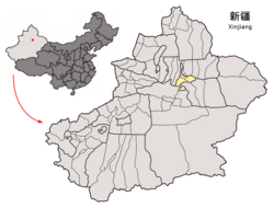 Ürümqi City in Xinjiang | |
| Coordinates: 43°28′19″N 87°24′36″E | |
| Country | People's Republic of China |
| Province | Xinjiang |
| Prefecture-level city | Ürümqi |
| Time zone | UTC+8 (China Standard) |
| Ürümqi County | |||||||||
|---|---|---|---|---|---|---|---|---|---|
| Chinese name | |||||||||
| Simplified Chinese | 乌鲁木齐县 | ||||||||
| Traditional Chinese | 烏魯木齊縣 | ||||||||
| Postal | Urumtsi | ||||||||
| |||||||||
| Alternative Chinese name | |||||||||
| Simplified Chinese | 迪化县 | ||||||||
| Traditional Chinese | 迪化縣 | ||||||||
| |||||||||
| Uyghur name | |||||||||
| Uyghur | ئۈرۈمچى ناھىيىسى | ||||||||
| |||||||||
According to Xingjian geographic graduate school of Chinese Section College, the geographical midpoint of Asia is located within the county.[1] Urumqi Glacier No.1, the glacier closest to an urban area in the world is also in the county.[2]
References
- "43° 40' 52"N 87° 19' 52" E Geographic Center of Asia – The Heart of Asia (亚洲之心) – Xinjiang (新疆), China". confluence.org. Confluence. 22 June 2006. Archived from the original on 2 June 2016. Retrieved 10 November 2016.
- "天山一号冰川". Urumqi County Government. 15 November 2017. Retrieved 17 November 2019.
External links
- http://www.wlmqx.gov.cn/ - Ürümqi County official website
Authority control | |
|---|---|
| General | |
| National libraries | |
This Xinjiang location article is a stub. You can help Wikipedia by expanding it. |
На других языках
- [en] Ürümqi County
[ru] Урумчи (уезд)
Уезд Урумчи́ (кит. упр. 乌鲁木齐县, пиньинь Wūlǔmùqí xiàn, уйг. ئۈرۈمچى ناھىيىسى, Ürümchi Nahiyisi) — уезд городского округа Урумчи Синьцзян-Уйгурского автономного района КНР.Текст в блоке "Читать" взят с сайта "Википедия" и доступен по лицензии Creative Commons Attribution-ShareAlike; в отдельных случаях могут действовать дополнительные условия.
Другой контент может иметь иную лицензию. Перед использованием материалов сайта WikiSort.org внимательно изучите правила лицензирования конкретных элементов наполнения сайта.
Другой контент может иметь иную лицензию. Перед использованием материалов сайта WikiSort.org внимательно изучите правила лицензирования конкретных элементов наполнения сайта.
2019-2026
WikiSort.org - проект по пересортировке и дополнению контента Википедии
WikiSort.org - проект по пересортировке и дополнению контента Википедии