world.wikisort.org - China
Xinping Yi and Dai Autonomous County (Chinese: 新平彝族傣族自治县; pinyin: Xīnpíng Yízú Dǎizú Zìzhìxiàn) is an autonomous county located in the central part of Yunnan Province, China. It is the westernmost county-level division of the prefecture-level city of Yuxi.
Xinping
新平县 | |
|---|---|
Autonomous county | |
| 新平彝族傣族自治县 Xinping Yi and Dai Autonomous County | |
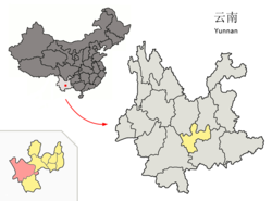 Location of Xinping County (pink) and Yuxi City (yellow) within Yunnan | |
| Country | People's Republic of China |
| Province | Yunnan |
| Prefecture-level city | Yuxi |
| Area | |
| • Total | 1,114 km2 (430 sq mi) |
| Population | |
| • Total | 260,035 |
| • Density | 230/km2 (600/sq mi) |
| Time zone | UTC+8 (CST) |
| Postal code | 653400 |
| Area code | 0877 |
| Website | www |
Administrative divisions
Xinping Yi and Dai Autonomous County has 2 subdistricts, 4 towns and 6 townships.[1]
- 2 subdistricts
- Guishan (桂山街道)
- Gucheng (古城街道)
- 4 towns
|
|
- 6 townships
|
|
Ethnic groups
The Xinping County Gazetteer (1993:106, 118) lists the following Yi and Hani subgroups.
- Yi: 111,555 (1987); subgroups are Niesu 聂苏, Nasu 纳苏, Chesu 车苏, Lalu 腊鲁, Lawu 拉乌, Mili 咪利, Micha 密查, Xiangtang 香堂, Luowu 罗武, Menghua 蒙化
- Hani: 9,547 (1987)
- Kaduo 卡多: Wajiao 挖窖[2] of Jianxing 建兴乡; Wasi 瓦寺[3] and Baizhi 柏枝[4] of Pingzhang 平掌乡; Shengli 胜利[5] of Mosha 漠沙乡
- Nuobi 糯比 and Suobi 梭比: Meiziqing 梅子箐[6] of Jianxing 建兴乡; Dazhai 大寨 of Fuxing 复兴
- Woni 窝尼: Yani 亚尼[7] of Pingdian 平甸
- Duota 堕塔: Xinzhai 新寨村[8] of Panlong 盘龙
- Biyue 碧约: Mowei 磨味[9] of Jianxing 建兴乡
There are various Tai ethnic groups in Xinping County.[10] They numbered 40,890 (15.54%) of the total population of Xinping County as of 2000, and include the following subgroups.[11]
- Tai Kha 傣卡 (Chinese Dai 汉傣): in Mosha Town 漠沙镇 and Yaojie Town 腰街镇
- Tai Sa 傣沙 (Tai Xa): in Mosha Township 漠沙镇
- Tai Ya 傣雅 (Tai Yalun 傣雅伦): in Gasa Town 嘎洒镇 and Shuitang Township 水塘镇
These three groups are known as the 花腰傣, or 'Flowery-waisted Tai' due to the style of their women's clothing. Local Tai languages include the Yuánxīn 元新 dialect of Tai Hongjin.
The Damuyu Flowery-Waist Dai Cultural and Ecological Tourist Village (大沐浴花腰傣文化生态旅游村) is located in Longhe Village 龙河村, Mosha Township 漠沙镇.
Climate
| Climate data for Xinping (1981−2010) | |||||||||||||
|---|---|---|---|---|---|---|---|---|---|---|---|---|---|
| Month | Jan | Feb | Mar | Apr | May | Jun | Jul | Aug | Sep | Oct | Nov | Dec | Year |
| Record high °C (°F) | 24.8 (76.6) |
28.7 (83.7) |
30.9 (87.6) |
33.0 (91.4) |
33.5 (92.3) |
31.6 (88.9) |
31.4 (88.5) |
31.2 (88.2) |
30.5 (86.9) |
29.2 (84.6) |
26.4 (79.5) |
25.3 (77.5) |
33.5 (92.3) |
| Average high °C (°F) | 18.3 (64.9) |
20.9 (69.6) |
24.4 (75.9) |
27.1 (80.8) |
27.1 (80.8) |
26.9 (80.4) |
26.4 (79.5) |
26.8 (80.2) |
25.7 (78.3) |
23.4 (74.1) |
20.3 (68.5) |
17.5 (63.5) |
23.7 (74.7) |
| Daily mean °C (°F) | 11.0 (51.8) |
13.2 (55.8) |
16.8 (62.2) |
19.8 (67.6) |
21.4 (70.5) |
22.2 (72.0) |
21.8 (71.2) |
21.4 (70.5) |
20.1 (68.2) |
18.0 (64.4) |
14.0 (57.2) |
10.8 (51.4) |
17.5 (63.6) |
| Average low °C (°F) | 5.8 (42.4) |
7.3 (45.1) |
10.5 (50.9) |
13.8 (56.8) |
16.8 (62.2) |
18.9 (66.0) |
18.8 (65.8) |
18.1 (64.6) |
16.8 (62.2) |
14.7 (58.5) |
10.0 (50.0) |
6.4 (43.5) |
13.2 (55.7) |
| Record low °C (°F) | −0.6 (30.9) |
1.0 (33.8) |
−0.8 (30.6) |
5.9 (42.6) |
9.0 (48.2) |
13.5 (56.3) |
14.0 (57.2) |
13.1 (55.6) |
9.1 (48.4) |
7.2 (45.0) |
0.9 (33.6) |
−2.7 (27.1) |
−2.7 (27.1) |
| Average precipitation mm (inches) | 15.7 (0.62) |
18.1 (0.71) |
20.1 (0.79) |
41.2 (1.62) |
102.7 (4.04) |
138.7 (5.46) |
174.9 (6.89) |
174.4 (6.87) |
109.5 (4.31) |
87.0 (3.43) |
49.7 (1.96) |
19.6 (0.77) |
951.6 (37.47) |
| Average relative humidity (%) | 72 | 63 | 55 | 57 | 68 | 78 | 84 | 84 | 83 | 82 | 81 | 79 | 74 |
| Source: China Meteorological Data Service Center[12] | |||||||||||||
References
- "国家统计局" (in Chinese). National Bureau of Statistics of the People's Republic of China. Retrieved 2021-12-07.
- "新平县建兴乡挖窖村民委员会". Archived from the original on 2015-05-29. Retrieved 2013-08-19.
- "新平县平掌乡瓦寺村民委员会". Archived from the original on 2015-05-29. Retrieved 2013-08-19.
- "新平县平掌乡柏枝村民委员会". Archived from the original on 2015-05-29. Retrieved 2013-08-19.
- "新平县漠沙镇胜利村民委员会". Archived from the original on 2015-05-29. Retrieved 2013-08-19.
- "新平县建兴乡马鹿村民委员会梅子箐". Archived from the original on 2015-05-29. Retrieved 2013-08-19.
- "新平县桂山镇亚尼村民委员会". Archived from the original on 2015-05-29. Retrieved 2013-08-19.
- "新平县建兴乡盘龙村民委员会新寨". Archived from the original on 2015-05-29. Retrieved 2013-08-19.
- "新平县建兴乡磨味村民委员会". Archived from the original on 2015-05-29. Retrieved 2013-08-19.
- Edmondson, Jerold A. 2008. "Shan and other Northern Tier Southeast Tai languages of Myanmar and China: Themes and Variations." In Diller, Anthony, Jerold Edmondson, & Yongxian Luo, (eds.) The Tai–Kadai languages. London: Routledge.
- 新平县旅游局 (2004). 花腰傣之乡:新平体脸游. ISBN 7-81068-883-9.
- 中国地面气候标准值月值(1981-2010) (in Simplified Chinese). China Meteorological Data Service Center. Retrieved 5 November 2022.
- Xinping County Ethnic Gazetteer Editorial Committee, ed. (1992). 新平彝族傣族自治縣民族 [Xinping County Ethnic Gazetteer]. Kunming: 云南民族出版社 [Yunnan Nationalities Press].
External links
This Yunnan location article is a stub. You can help Wikipedia by expanding it. |
На других языках
- [en] Xinping Yi and Dai Autonomous County
[ru] Синьпин-И-Дайский автономный уезд
Синьпин-И-Дайский автономный уезд (кит. упр. 新平彝族傣族自治县, пиньинь Xīnpíng Yízú Dǎizú zìzhìxiàn) — автономный уезд городского округа Юйси провинции Юньнань (КНР).Другой контент может иметь иную лицензию. Перед использованием материалов сайта WikiSort.org внимательно изучите правила лицензирования конкретных элементов наполнения сайта.
WikiSort.org - проект по пересортировке и дополнению контента Википедии