world.wikisort.org - China
Luoping County (Chinese: 罗平县; pinyin: Luópíng Xiàn) is located in Qujing City, in eastern Yunnan province, China, bordering Guizhou province to the east and the Guangxi Zhuang Autonomous Region to the southeast.
This article needs additional citations for verification. (December 2021) |
Luoping County
罗平县 | |
|---|---|
County | |
 Location of Luoping County (pink) and Qujing City (yellow) within Yunnan | |
| Country | People's Republic of China |
| Province | Yunnan |
| Prefecture-level city | Qujing |
| Area | |
| • Total | 2,096 km2 (809 sq mi) |
| Population | |
| • Total | 508,345 |
| • Density | 240/km2 (630/sq mi) |
| Time zone | UTC+8 (CST) |
| Postal code | 655800 |
| Area code | 0874 |
| Website | www |

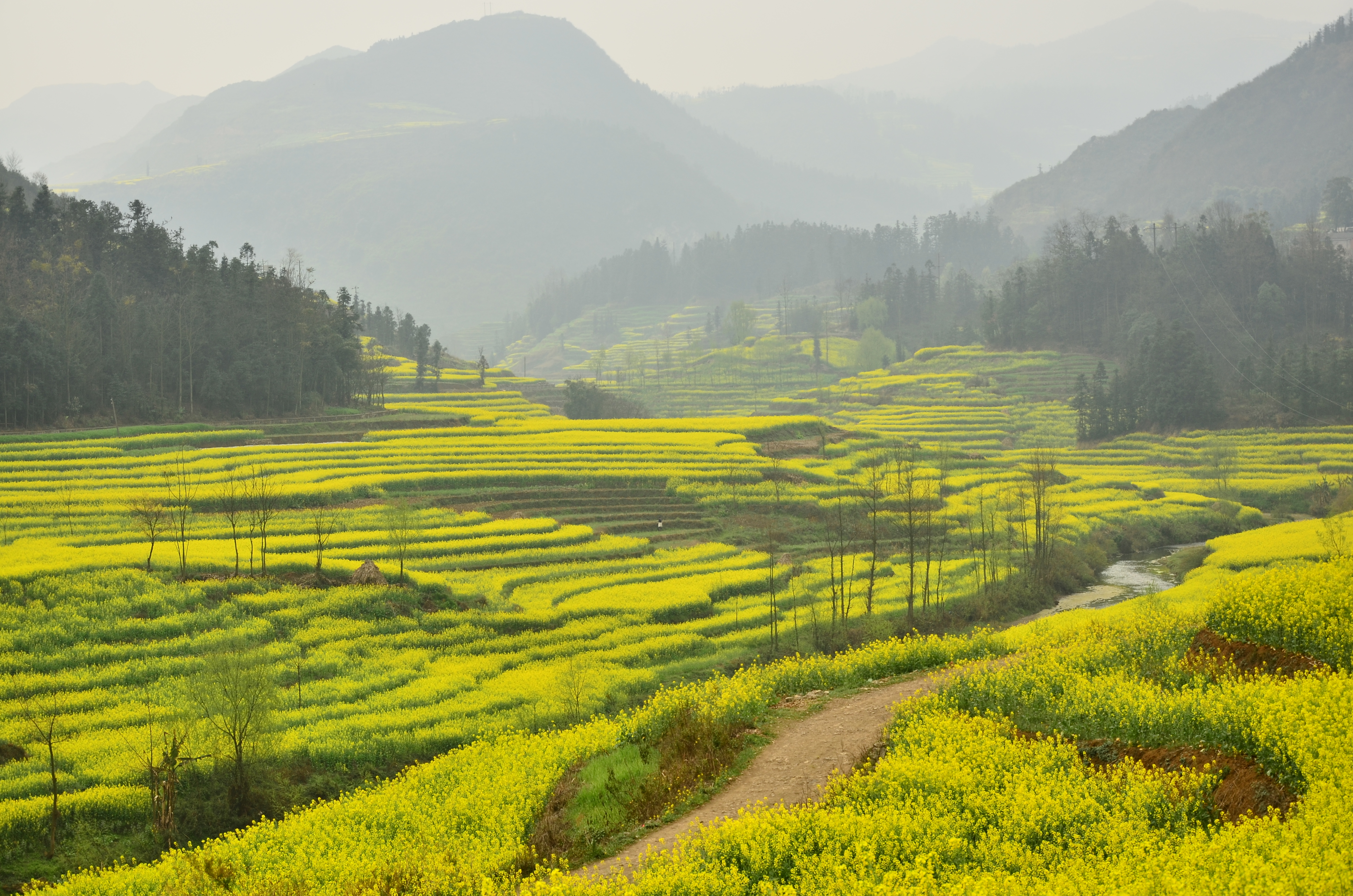
The county of Luoping in eastern Yunnan is noted for its springtime scenery, when its fields of canola (also known as rapeseed) plants are in full bloom, surrounding the area's mountains with a blanket of golden flowers.[citation needed]
Located near where Yunnan meets Guizhou and Guangxi, Luoping is about 240 kilometers east of Kunming. Not unlike the terraced fields of Yuanyang in southern Yunnan, Luoping's canola fields attract many photographers.[citation needed]
The canola flowering lasts until late June. During this high travel season for the county regular buses leave from Kunming's bus stations on an almost hourly basis.[citation needed]
Administrative divisions
Luoping County has 3 subdistricts, 4 towns, 3 townships and 3 ethnic townships.[1]
- 3 subdistricts
- Luoxiong (罗雄街道)
- Lashan (腊山街道)
- Jiulong (九龙街道)
- 4 towns
|
|
- 3 townships
- Dashuijing (大水井乡)
- Zhongshan (钟山乡)
- Laochang (老厂乡)
- 3 ethnic townships
- Lubuge Buyi and Miao (鲁布革布依族苗族乡)
- Jiuwuji Yi (旧屋基彝族乡)
- Zhangdi Buyi (长底布依族乡)
Ethnic groups
The Luoping County Gazetteer (1995:601) lists the following Yi subgroups and their respective locations.
- Wopu 窝普 / Large Black Yi 大黑彝
- Majie town 马街镇: Dayiben 大以本, Jiudaogou 九道沟, Jigu 吉古
- Agang township 阿岗乡: Satuge 洒土格
- Nasupu 纳苏普 / Small Black Yi 小黑彝 (pop. 20,000+)
- Huancheng township 环城乡: Poyi 坡衣
- Fule town 富乐镇: Lefeng 乐丰
- Alu township 阿鲁乡: Qile 启乐, Feige 非格
- Agang township 阿岗乡: Yiyi 以宜
- Jiuwuji township 旧屋基乡: Anmule 安木勒, Muxing 木星, Fawan 法弯, Laozhai 老寨
- Majie town 马街镇: Daimo 歹墨, Luji 鲁基
- Changdi township 长底乡: Deshao 德沙, Bazuo 把佐
- Gepu 戈仆 / Gan Yi 甘/干彝 (pop. 4,300+)
- Huancheng township 环城乡: Zhonghe 中和, Budai 补歹
- Awu 阿武 (pop. 100)
- Huancheng township 环城乡
- Luwu 鲁屋 / White Yi 白彝
Climate
| Climate data for Luoping (1981−2010) | |||||||||||||
|---|---|---|---|---|---|---|---|---|---|---|---|---|---|
| Month | Jan | Feb | Mar | Apr | May | Jun | Jul | Aug | Sep | Oct | Nov | Dec | Year |
| Record high °C (°F) | 25.4 (77.7) |
29.6 (85.3) |
32.3 (90.1) |
34.0 (93.2) |
36.0 (96.8) |
32.9 (91.2) |
31.9 (89.4) |
30.7 (87.3) |
31.3 (88.3) |
29.1 (84.4) |
27.2 (81.0) |
26.7 (80.1) |
36.0 (96.8) |
| Average high °C (°F) | 11.8 (53.2) |
14.7 (58.5) |
19.5 (67.1) |
23.9 (75.0) |
25.4 (77.7) |
25.4 (77.7) |
25.8 (78.4) |
25.7 (78.3) |
23.7 (74.7) |
20.1 (68.2) |
16.8 (62.2) |
13.0 (55.4) |
20.5 (68.9) |
| Daily mean °C (°F) | 6.7 (44.1) |
9.0 (48.2) |
12.9 (55.2) |
17.3 (63.1) |
19.7 (67.5) |
21.0 (69.8) |
21.3 (70.3) |
20.9 (69.6) |
18.9 (66.0) |
15.8 (60.4) |
11.9 (53.4) |
7.8 (46.0) |
15.3 (59.5) |
| Average low °C (°F) | 3.4 (38.1) |
5.1 (41.2) |
8.1 (46.6) |
12.3 (54.1) |
15.5 (59.9) |
17.9 (64.2) |
18.4 (65.1) |
17.7 (63.9) |
15.8 (60.4) |
13.1 (55.6) |
8.5 (47.3) |
4.3 (39.7) |
11.7 (53.0) |
| Record low °C (°F) | −3.5 (25.7) |
−2.3 (27.9) |
−3.6 (25.5) |
−3.0 (26.6) |
4.3 (39.7) |
11.7 (53.1) |
12.7 (54.9) |
11.9 (53.4) |
7.1 (44.8) |
3.1 (37.6) |
−2.6 (27.3) |
−13.5 (7.7) |
−13.5 (7.7) |
| Average precipitation mm (inches) | 27.1 (1.07) |
31.9 (1.26) |
36.0 (1.42) |
49.3 (1.94) |
157.7 (6.21) |
312.0 (12.28) |
340.4 (13.40) |
270.8 (10.66) |
189.0 (7.44) |
115.5 (4.55) |
48.0 (1.89) |
21.9 (0.86) |
1,599.6 (62.98) |
| Average relative humidity (%) | 86 | 79 | 74 | 71 | 76 | 85 | 87 | 87 | 86 | 88 | 86 | 86 | 83 |
| Source: China Meteorological Data Service Center[2] | |||||||||||||
References
- "国家统计局" (in Chinese). National Bureau of Statistics of the People's Republic of China. Retrieved 2021-12-07.
- 中国地面气候标准值月值(1981-2010) (in Simplified Chinese). China Meteorological Data Service Center. Retrieved 5 November 2022.
External links
This Yunnan location article is a stub. You can help Wikipedia by expanding it. |
На других языках
[de] Luoping
Der Kreis Luoping (.mw-parser-output .Hans{font-size:110%}罗平县, Luópíng Xiàn) ist ein Kreis im Osten der chinesischen Provinz Yunnan. Er gehört zum Verwaltungsgebiet der bezirksfreien Stadt Qujing. Luoping hat eine Fläche von 3.009 Quadratkilometern und zählt 535.565 Einwohner (Stand: Zensus 2020).[1] Sein Hauptort ist die Großgemeinde Luoxiong (罗雄镇).- [en] Luoping County
[ru] Лопин (Цюйцзин)
Лопи́н (кит. упр. 罗平, пиньинь Luópíng) — уезд городского округа Цюйцзин провинции Юньнань (КНР).Другой контент может иметь иную лицензию. Перед использованием материалов сайта WikiSort.org внимательно изучите правила лицензирования конкретных элементов наполнения сайта.
WikiSort.org - проект по пересортировке и дополнению контента Википедии