 The approach to the western side of the village from the direction of Wolterton and Wickmere.
 The approach to the village from Erpingham where the lane crosses Scarrow Beck.
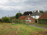
 The village notice board which stands outside the boundary wall of the parish church of Our Lady and Saint Margaret.
 The Un-bridged ford across Scarrow Beck a short distance south of the village.
 This memorial set into the wall of the Parish Church commemorates the men of Calthorpe who gave there lives during the First World War 1914 to 1918.
 the 15th-century octagonal font with bowl panels decorated with tracery with the underside of the bowl supported by carved demi-figures of angels. The pedestal has four hunched lions, one to each corner with a double tracery panel between each lion.
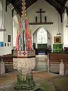 The tall ornate font cover of the font dates from the 20th century and originates from the parish church in Buxton, Norfolk.
world.wikisort.org - United_Kingdom
Calthorpe is a small village and former civil parish, now in the parish of Erpingham, in the North Norfolk district, in the county of Norfolk, England.[1] The village is located 0.5 miles (0.80 km) west of the village of Erpingham, 3.4 miles (5.5 km) north of the nearest town of Aylsham and is 15.8 miles (25.4 km) north of the nearest city of Norwich.[2] The nearest railway station is at Gunton for the Bittern Line which runs between Sheringham, Cromer and Norwich and is 7.8 miles (12.6 km)[3] from the village.[2] The nearest airport is Norwich International 14.2 miles (22.9 km)[3] south of the village. In 1931 the parish had a population of 143.[4]
| Calthorpe | |
|---|---|
 Calthorpe Parish Church | |
 Calthorpe Location within Norfolk | |
| OS grid reference | TG1800631802 |
| Civil parish | |
| District | |
| Shire county | |
| Region | |
| Country | England |
| Sovereign state | United Kingdom |
| Post town | NORWICH |
| Postcode district | NR11 |
| Police | Norfolk |
| Fire | Norfolk |
| Ambulance | East of England |
Etymology
The village name devolved from Old Scandinavian language and has the meaning of outlying farm or small hamlet owned by a man named Kali.[5]
Description
The village was once a parish itself but was amalgamated into the civil parish of Erpingham in the re-organisation of Norfolk parishes 1935. The village and its parish church are centred on a crossroads of Wall road which runs from Wolterton and Erpingham, and Scarrow Beck Lane which runs north to south through the village and links Wickmere to the north with Ingworth.
Domesday Book
Calthorpe is mentioned in Domesday Book of 1086, where it is called Calatorp or Caletorp.[6] The main landholders of the parish were Roger Bigod,[7] The Abbot of Saint Benedict of Holme[8] and Breton called Tihel of HellÈan. Before 1066 it was held by Godwin of Scottow[7][9] and was valued at £4 but at the time of the survey the value was listed as £6.[7] The manor was 8 furlongs in Length and 5½ in width and had a taxable value of 9½ pennies.[7] Saint Benedict holdings had 7 smallholders, 7 villages, 1 plough in Lordship, 3 mens ploughs, 4 acres meadow, woodland Pannage for 15 pigs, 1 mill and one third of another.[8] In the Domesday survey fractions[10] were used to indicate that the entry, in this case the second mill, was on an estate that lay within more than one parish. The survey list Guerri and Osbort as being tenants of Tihel of HellÈan.[11] Within these tenant holdings there were 8 smallholders, 3 villagers, 1 plough owned by the lord of the manor, 1½ men's ploughs, 6 acres of meadow, woodland Pannage for 15 pigs, One third of a mill. 3 cobs, 1 head of cattle, 10 pigs and two beehives.[11]
Landmarks and structures
Manor houses
Within the parish of Calthorpe there is documented evidence of several manor house dating from the medieval period but all traces have now disappeared and there exact locations are not known. The names of three have been recorded as Calthorpe Hall, Hook Hall and Kybald Hall all of which are referred to in medieval documents and in White's gazetteer of 1845.[12]
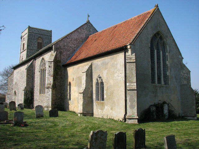
The parish church of Our Lady and Saint Margaret
The church standing today was first built in the medieval period although there are remnants of an earlier Norman church within the building. The Norman church replaced an earlier church. Most of the remaining church was built in the 13th century.[13] The church tower was built in the 13th century and is unbuttressed and faced in knapped flint work. Internally the tower has a low arch with several courses of mouldings which finish into the impost.[14] The chancel dates from the 13th century with the nave being re-built sometime in the 15th century.[13] Originally there was a porch on the south elevation doorway now gone. On the north elevation is the door used today which has a recess above the door on the inside which once contained a Saint Christopher[13] as was the practice of placing the saint opposite the main entrance to welcome the parishioners and travellers to the church.[13] The timber roof of the nave dates from the medieval period and is constructed with rows of Arch-braced trusses.[14] The nave has four early English triple lancets perpendicular windows of which only one has any decoration. The widow in the chancel was installed in 1822.[13] The octagonal font dates from the 15th century and sits on a pedestal with four lions, one to each corner with double tracery panel between each hunched lion. The octagonal bowls panels are also decorated with tracery with the underside of the bowl supported by carved demi-figures of angels.[14] The font is topped with a red and green brightly decorated cover which towers above the font. The cover originates from the parish church of Saint Andrews at Buxton.[15] The church is a Grade II listed building (English Heritage Building ID: 224484).[16]
First World War Memorial Plaque
Set into the wall of the church to the left of the main door is a memorial plaque to the men of the parish of Calthorpe who gave there life during the 1914 – 1918 World War. The inscription reads
IN MEMORY OF THE MEN OF THIS PARISH
WHO LOST THEIR LIVES IN THE WAR
1914~1918 THIS TABLET IS PLACED
BY THE PEOPLE OF CALTHORP
The men listed here are all on the plaque
- Alfred Allard
- William Anderson
- Arthur Brett
- Barney Burgess
- John Burton
- Basil Horner
- William Horner
- Joseph Newstead
- Jack Wright
- R.I.P.
Calthorpe Watermill
The Domesday survey recorded that there were two watermills in Calthorpe[17] although there were no documented evidence reference the watermills until 1249.[17] By that date there was only one watermill south of the village on the River Bure.[17] The watermill was constructed from timber and needed constant maintenance, a situation which was documented by the rectory accounts. The mills situation made access difficult and this eventually lead to the mill falling into disrepair until in 1453[17] it is recorded as having collapsed.
Gallery


References
- Street Atlas – Norfolk. Street map sourced from the Ordnance Survey (Pocket ed.). Philip's. 2003. p. 21. ISBN 9780540094851.
- OS Explorer Map 252 – Norfolk Coast East. Ordnance Survey detailed Explorer Map (A3 ed.). Ordnance Survey. 21 July 2008. p. 1. ISBN 9780319240380.
- Street & Road Maps – Norfolk. Street Map with distance markers (1 ed.). Geographers' A-Z Map Company Ltd. 2008. p. 228. ISBN 9781843486145.
- "Population statistics Calthorpe AP/CP through time". A Vision of Britain through Time. Retrieved 21 October 2022.
- James, Rye (1991). A Popular Guide to Norfolk Place-names. Calthorpe, Norfolk. Larks press. p. 47. ISBN 0948400153.
- Hinde, Thomas. (1985). The Domesday Book, Englands Heritage, Then and Now. Reference to the Domesday entry for Calthorpe (1 ed.). Guild Publishing London. p. 187. ISBN 9781858334400.
- General Editor:Morris, John (1086). Domesday Book – Norfolk (Part One). Land of Roger Bigot (1984 ed.). Phillimore, Chichester. pp. 9–87. ISBN 9780850334791.
{{cite book}}:|author=has generic name (help) - General Editor:Morris, John (1086). Domesday Book – Norfolk (Part Two). Land of St Benedidt of Holme for the supplies of the Monks (1984 ed.). Phillimore, Chichester. pp. 17–26, 217b, 218a. ISBN 9780850334791.
{{cite book}}:|author=has generic name (help) - "Name: Godwin of Scottow". References to Godwin of Scottow in the Domesday Book. Anna Powell-Smith. Domesday data created by Professor J.J.N. Palmer, University of Hull. Archived from the original on 19 August 2014. Retrieved 15 August 2014.
- The Normans in Norfolk, By Sue Margeson, Fabienne Seillier and Andrew Rogerson, Pub:1994, Page 21, ISBN 0-903101-62-9
- General Editor:Morris, John (1086). Domesday Book – Norfolk (Part Two). Land of Tihel (1984 ed.). Phillimore, Chichester. pp. 37–38, 261b, 262a. ISBN 9780850334791.
{{cite book}}:|author=has generic name (help) - "William White's History, Gazetteer, and Directory of Norfolk 1845". Reference to Hook Hall and Kybald Hall farms. GENUKI. Retrieved 15 August 2014.
- D.P. Mortlock and C.V. Roberts (1981). The Popular Guide to Norfolk Churches No. 1 North East Norfolk. Description of the church with dates. Acorn Editions – Fakenham Norfolk. p. 24. ISBN 9780906554043.
- Pevsner, Nikolaus (1976). Norfolk: Norwich and North-east v. 1 (Pevsner Architectural Guides: Buildings of England). Reference and description to the Parish Church at Calthorpe. Penguin Books Ltd. p. 110. ISBN 9780300096071.
- "Calthorpe: Our Lady w St Margaret, Calthorpe". Description of the church and reference to the origins of the font cover. The Church of England. Retrieved 15 August 2014.
- "Church of St Margaret, Erpingham with Calthorpe". British Listed Building detail – Grade II listed building. British Listed Building. Retrieved 16 August 2014.
- "Norfolk Mills – Calthorpe Watermill". Description and History of the Watermill. Norfolk Mills Copyright Jonathan Neville 2004. Retrieved 15 August 2014.
External links
![]() Media related to Calthorpe, Norfolk at Wikimedia Commons
Media related to Calthorpe, Norfolk at Wikimedia Commons
Текст в блоке "Читать" взят с сайта "Википедия" и доступен по лицензии Creative Commons Attribution-ShareAlike; в отдельных случаях могут действовать дополнительные условия.
Другой контент может иметь иную лицензию. Перед использованием материалов сайта WikiSort.org внимательно изучите правила лицензирования конкретных элементов наполнения сайта.
Другой контент может иметь иную лицензию. Перед использованием материалов сайта WikiSort.org внимательно изучите правила лицензирования конкретных элементов наполнения сайта.
2019-2025
WikiSort.org - проект по пересортировке и дополнению контента Википедии
WikiSort.org - проект по пересортировке и дополнению контента Википедии