world.wikisort.org - United_Kingdom
The East of England is one of the nine official regions of England. This region was created in 1994 and was adopted for statistics purposes from 1999. It includes the ceremonial counties of Bedfordshire, Cambridgeshire, Essex, Hertfordshire, Norfolk and Suffolk. Essex has the highest population in the region.[1]
This article has multiple issues. Please help improve it or discuss these issues on the talk page. (Learn how and when to remove these template messages)
|
East of England | |
|---|---|
Region of England | |
 | |
| Sovereign state | |
| Constituent country | |
| Largest city | Norwich |
| Counties | Bedfordshire Cambridgeshire Essex Hertfordshire Norfolk Suffolk Historically Huntingdonshire |
| Government | |
| • Leaders' board | East of England Local Government Association |
| Area | |
| • Total | 19,120 km2 (7,380 sq mi) |
| • Rank | 2nd |
| Population (2021 census) | |
| • Total | 6,334,500 |
| • Rank | 4th |
| • Density | 330/km2 (860/sq mi) |
| GVA | |
| • Total | £146 billion |
| • Per capita | £23,970 (3rd) |
| ITL code | TLH |
| ONS code | E12000006 |
| Website | www |
The population of the East of England region in 2018 was 6.24 million.[2] Bedford, Luton, Basildon, Peterborough, Southend-on-Sea, Norwich, Ipswich, Colchester, Chelmsford and Cambridge are the region's most populous settlements.[3] The southern part of the region lies in the London commuter belt.
Geography

The East of England region has the lowest elevation range in the UK. Twenty percent of the region is below mean sea level, most of this in North Cambridgeshire, Norfolk and on the Essex Coast.[4][5] Most of the remaining area is of low elevation, with extensive glacial deposits.[6] The Fens, a large area of reclaimed marshland, are mostly in North Cambridgeshire.[7] The Fens include the lowest point in the country in the village of Holme: 2.75 metres (9.0 ft) below mean sea level. This area formerly included the body of open water known as Whittlesey Mere. The highest point in the region is at Clipper Down at 817 ft (249 m) above mean sea level, in the far southwestern corner of the region in the Ivinghoe Hills.[8][9][10]
Communities known as New Towns, responses to urban congestion and World War II destruction, appeared in Basildon and Harlow (Essex), as well as in Stevenage and Hemel Hempstead (Hertfordshire), in the 1950s and 1960s.[11] In the late 1960s, the Roskill Commission considered Cublington in Buckinghamshire, Thurleigh in Bedfordshire, Nuthampstead in Hertfordshire and Foulness in Essex as locations for a possible third airport for London. A new airport was not built, but a former Royal Air Force base at Stansted, which had previously been converted to civilian use redeveloped and expanded in the following decades.[12]
Historical use
| This article is part of a series within UK politics on the |
Politics of England |
|---|
 |
|
The East of England succeeded the standard statistical region East Anglia (which excluded Essex, Hertfordshire and Bedfordshire, then in the South East). The East of England civil defence region was identical to today's region.[13]
East Anglia with Home Counties
Essex, despite meaning East-Saxons, previously formed part of South East England, along with Bedfordshire and Hertfordshire, a mixture of definite and debatable Home counties. The earliest use of the term is from 1695. Charles Davenant, in An essay upon ways and means of supplying the war, wrote, "The Eleven Home Counties, which are thought in Land Taxes to pay more than their proportion..." then cited a list including these four. The term does not appear to have been used in taxation since the 18th century.[14]
Climate
This section does not cite any sources. (August 2020) |
East Anglia is one of the driest parts of the United Kingdom, with average rainfall ranging from 450 to 750 mm (18 to 30 in).[15] The area receives such low rainfall amounts because low pressure systems and weather fronts from the Atlantic lose a lot of moisture over land (and therefore are usually much weaker) by the time they reach Eastern England.[16]
Winter (mid-November – mid-March) is mostly cool, but non-prevailing cold easterly winds can affect the area from the continent. These can bring heavy snowfall if the winds interact with a low-pressure system over the Atlantic or France.[17] Northerly winds also can be cold but are not usually as cold as easterly winds. Westerly winds bring milder and, typically, wetter weather. Southerly winds usually bring mild air (if from the Atlantic or North Africa) but chill if coming from further east than Spain.[18]
Spring (mid-March – May) is a transitional season that initially can be chilly but is usually warm by late-April/May. The weather at this time is often changeable (within each day) and occasionally showery.[19]
Summer (June – mid-September) is usually warm. Continental air from mainland Europe or the Azores High usually leads to at least a few weeks of hot, balmy weather with prolonged warm to hot temperatures. The number of summer storms from the Atlantic, such as the remnants of a tropical storm, usually coincides with the location of the jet stream. The East tends to receive much less rain than the other regions.[20]
Autumn (mid-September – mid-November) is usually mild with some days being very unsettled and rainy and others warm. At least part of September and early October in the East have warm and settled weather, but only in rare years is there an Indian summer where fine weather marks the entire traditional harvest season.[21]
Demographics
Population
Ethnicity
| Ethnic group | 1991[22] | 2001[23] | 2011[24] | |||
|---|---|---|---|---|---|---|
| Number | % | Number | % | Number | % | |
| White: Total | 4,891,675 | 96.8% | 5,125,003 | 95.11% | 5,310,194 | 90.81% |
| White: British | 4,927,343 | 91.44% | 4,986,170 | 85.27% | ||
| White: Irish | 61,208 | 55,573 | ||||
| White: Irish Traveller/Gypsy | - | - | 8,165 | |||
| White: Other | 136,452 | 260,286 | ||||
| Asian or Asian British: Total | 99,720 | 2% | 142,137 | 2.63% | 278,372 | 4.76% |
| Asian or Asian British: Indian | 39,292 | 51,035 | 86,736 | |||
| Asian or Asian British: Pakistani | 24,713 | 38,790 | 66,270 | |||
| Asian or Asian British: Bangladeshi | 10,934 | 18,503 | 32,992 | |||
| Asian or Asian British: Chinese | 12,494 | 20,385 | 33,503 | |||
| Asian or Asian British: Asian Other | 12,287 | 13,424 | 58,871 | |||
| Black or Black British: Total | 42,310 | 0.8% | 48,464 | 0.89% | 117,442 | 2% |
| Black or Black British: Caribbean | 21,892 | 26,199 | 33,614 | |||
| Black or Black British: African | 6,373 | 16,968 | 69,925 | |||
| Black or Black British: Other | 14,045 | 5,297 | 13,903 | |||
| Mixed: Total | 57,984 | 1.07% | 112,116 | 1.91% | ||
| Mixed: White and Caribbean | 19,882 | 37,222 | ||||
| Mixed: White and African | 6,109 | 15,388 | ||||
| Mixed: White and Asian | 17,385 | 32,226 | ||||
| Mixed: Other Mixed | 14,608 | 27,280 | ||||
| Other: Total | 21,810 | 0.4% | 14,552 | 0.27% | 28,841 | 0.49% |
| Other: Arab | - | - | 10,367 | |||
| Other: Any other ethnic group | 21,810 | 0.4% | 14,552 | 18,474 | ||
| Total | 5,055,515 | 100% | 5,388,140 | 100% | 5,846,965 | 100% |
Politics
Elections

In the 2015 general election there was an overall swing of 0.25% from the Conservatives to Labour and the Liberal Democrats lost 16% of its vote. All of Hertfordshire and Suffolk is now Conservative. The region's electorate voted 49% Conservative, 22% Labour, 16% UKIP, 8% Liberal Democrat and 4% Green. Like other regions, the division of seats favours the dominant party in the region and the Conservatives had 52, Labour 4 (Cambridge, Luton South, Luton North and Norwich South), UKIP 1 (Clacton) and 1 Liberal Democrat (North Norfolk).[25]
| Number of MPs returned per party, total 58 (situation at end of parliament in brackets) | |||||||||
|---|---|---|---|---|---|---|---|---|---|
| Affiliation | 2010–15 | 2015–17 | 2017–19 | 2019-present | |||||
| Conservative Party | 52 | 52 | 50 (46) | 52 | |||||
| Liberal Democrats | 4 | 1 | 1 (2) | 1 | |||||
| Labour Party | 2 | 4 | 7 (5) | 5 | |||||
| The Independents | 0 | 0 | 0 (1) | 0 | |||||
| Independent | 0 | 1 | 0 (4) | 0 | |||||
Governance and regions
East of England Plan
The East of England Plan, a revision of the Regional Spatial Strategy for the East of England, was published on 12 May 2008. It was revoked on 3 January 2013.[26]
Local government
The official region consists of the following subdivisions:
| Map | Ceremonial county | Shire county / unitary | Districts |
|---|---|---|---|
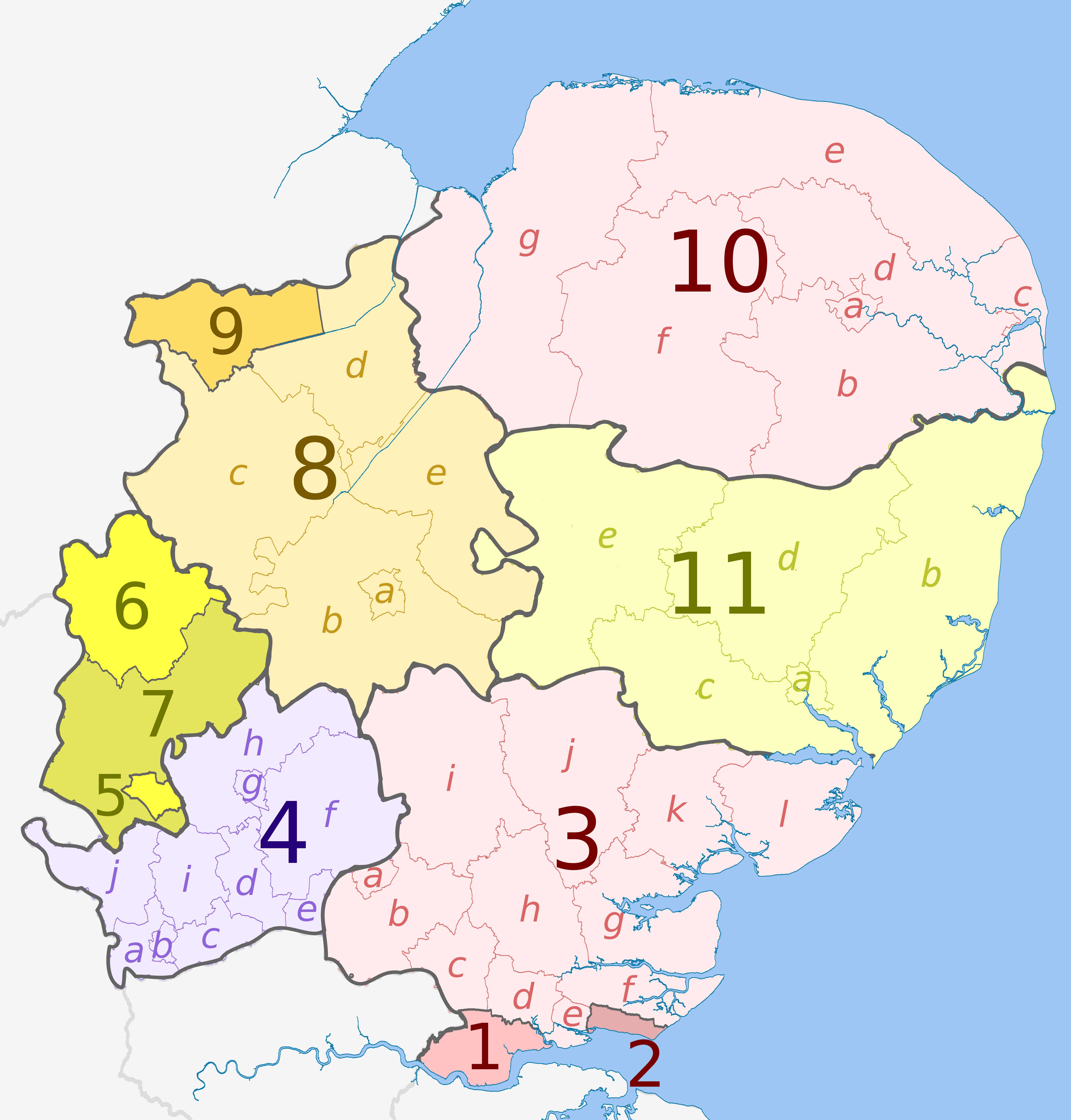 | Essex | 1. Thurrock U.A. | |
| 2. Southend-on-Sea U.A. | |||
| 3. Essex | a) Harlow, b) Epping Forest, c) Brentwood, d) Basildon, e) Castle Point, f) Rochford, g) Maldon, h) Chelmsford, i) Uttlesford, j) Braintree, k) Colchester, l) Tendring | ||
| 4. Hertfordshire | a) Three Rivers, b) Watford, c) Hertsmere, d) Welwyn Hatfield, e) Broxbourne, f) East Hertfordshire, g) Stevenage, h) North Hertfordshire, i) St Albans, j) Dacorum | ||
| Bedfordshire | 5. Luton U.A. | ||
| 6. Bedford U.A. | |||
| 7. Central Bedfordshire U.A. | |||
| Cambridgeshire | 8. Cambridgeshire | a) Cambridge, b) South Cambridgeshire, c) Huntingdonshire, d) Fenland, e) East Cambridgeshire | |
| 9. Peterborough U.A. | |||
| 10. Norfolk | a) Norwich, b) South Norfolk, c) Great Yarmouth, d) Broadland, e) North Norfolk, f) Breckland, g) King's Lynn and West Norfolk | ||
| 11. Suffolk | a) Ipswich, b) East Suffolk, c) Babergh, d) Mid Suffolk, e) West Suffolk | ||
Eurostat NUTS
In the Eurostat Nomenclature of Territorial Units for Statistics (NUTS), the East of England was a level-1 NUTS region, coded "UKH", which was subdivided as follows:
| NUTS 1 | Code | NUTS 2 | Code | NUTS 3 | Code |
|---|---|---|---|---|---|
| East of England | UKH | East Anglia | UKH1 | Peterborough | UKH11 |
 |
Cambridgeshire CC | UKH12 | |||
| Norfolk | UKH13 | ||||
| Suffolk | UKH14 | ||||
| Bedfordshire and Hertfordshire | UKH2 | Luton | UKH21 | ||
| Hertfordshire CC | UKH23 | ||||
| Bedford | UKH24 | ||||
| Central Bedfordshire | UKH25 | ||||
| Essex | UKH3 | Southend-on-Sea | UKH31 | ||
| Thurrock | UKH32 | ||||
| Essex CC | UKH33 | ||||
After the UK's departure from the EU, the UK NUTS regions were renamed as International Territorial Level regions in 2021.
History
This section does not cite any sources. (August 2020) |
Civil War and the Protectorate
The East of England was a major force and resource for Parliament and, in particular, in the form of the Eastern Association. Oliver Cromwell came from Huntingdon.[27]
Second World War
Norfolk, Suffolk and Essex played host to the American VIII Bomber Command and Ninth Air Force. The Imperial War Museum at Duxford has an exhibition, commemorating their participation and sacrifice, near to the M11 south of Cambridge.[28]
Stansted Airport was RAF Stansted Mountfitchet, home to the 344th Bombardment Group. The de Havilland Mosquito was mainly assembled at Hatfield and Leavesden, although much of the innovative wooden structure originated outside the region from the furniture industry of High Wycombe; the Mosquito entered service in 1942 with 105 Sqn at RAF Horsham St Faith. RAF Tempsford in Bedford is the airfield from where SOE secret agents for Europe took off, with 138 Sqn which parachuted agents and equipment and 161 Sqn which landed and retrieved agents. 19 Sqn at Duxford was the first to be equipped with the Spitfire on 4 August 1938.[29]
Cold War
The 81st Tactical Fighter Wing was at RAF Bentwaters from January 1952 and also at RAF Woodbridge; in the late 1980s some of the aircraft went to RAF Alconbury. Alconbury closed in 1992 and Bentwaters closed in 1993, with the American air forces being in the area for 42 years; the USAF aircraft subsequently moved to Spangdahlem Air Base in Rhineland-Palatinate, Germany.[30]
At RAF Marham in west Norfolk, 214 Sqn with the Vickers Valiant developed the RAF's refuelling system; later the squadron would be equipped with the Handley Page Victor. Work on refuelling had also taken place at RAF Tarrant Rushton in Dorset.[31]
From the 1950s, RAF Wyton was an important reconnaissance base for the RAF, mainly 543 Sqn. The base is now home of the Defence Intelligence Fusion Centre, previously known as JARIC, or the Joint Air Reconnaissance Intelligence Centre from 1956.[32]
This section needs additional citations for verification. (December 2018) |
Healthcare
This section does not cite any sources. (August 2020) |
NHS East of England, which was the strategic health authority for the area until the abolition of these areas in 2013, is on Capital Park, next to Fulbourn Tesco, Fulbourn Hospital, and the Cambridge-Ipswich railway, on the eastern edge of Cambridge. The East of England Ambulance Service is on Cambourne Business Park on Cambourne, of the A428 (the former A45) west of Cambridge. The East Anglian Air Ambulance operates from Cambridge Airport and Norwich Airport; Essex Air Ambulance operates from Boreham.[33]
Economy
This section needs additional citations for verification. (August 2020) |
This section may contain an excessive amount of intricate detail that may interest only a particular audience. (December 2018) |
The former electricity company for the area, Eastern Electricity, has the area's distribution now looked after by UK Power Networks at Fore Hamlet in Ipswich. UK Power Networks also looks after London and most of the South-East. Business Link in the East of England is next door to the headquarters of T-Mobile UK in Hatfield, at the roundabout of the A1057 and the A1001 on the Bishops Square Business Park.[34][35] The region's Manufacturing Advisory Service is at Melbourn in Cambridgeshire, off the A10 and north of Royston.[36] UK Trade & Investment for the region is in Histon[37] with its international trade team based next to Magdalene College.
Hertfordshire

The Greater Watford area is home to British Waterways, Vinci (which bought Taylor Woodrow in 2008), the UK of the international firm Total Oil, retailers TK Maxx, Bathstore, Majestic Wine, Mothercare, Costco and Smiths Detection, Iveco, BrightHouse (at Abbots Langley), Leavesden Film Studios, Sanyo, Europcar, Olympus, Kenwood and Beko electronic goods manufacturers, Wetherspoons pub chains, the European HQ of the Hilton hotel group and Nestlé Waters; in Garston is the UK headquarters of the Seventh-day Adventist Church, on the A412 and the Building Research Establishment. Comet Group and Camelot Group (owners of the National Lottery), on the A4145, are in Rickmansworth. Ferrero (maker of Nutella and Kinder Chocolate) is in Croxley Green. Renault and Skanska (construction) are in Maple Cross.[38]
Bedfordshire

Moto Hospitality has its headquarters at Toddington in Bedfordshire (at the Toddington services).
Luton is home to EasyJet,(based at the airport), Hain Celestial Group (which makes Linda McCartney Foods and is based on the B579 in Biscot), Eurolines (UK office), Thomson Holidays (based at Wigmore on the eastern edge of the town) and Chevrolet (at Griffin House, the Vauxhall head office). At the 85-acre Capability Green off the A1081 and junction 10a of the M1, is the Stonegate Pub Company (owner of Scream Pubs, Yates's, Slug and Lettuce and Hogshead), InBev UK (which bought most of Whitbread's beer brands), Chargemaster (electric vehicle network under the POLAR brand), AstraZeneca's UK Marketing Company division and Alexon Group (ladies clothing). Vauxhall produced its last Vauxhall Vectra in March 2002 at the plant near the A6/A505 roundabout, and now makes vans (Vivaro/Renault Trafic) at the former Bedford Vehicles plant, based in the north of the town at the GM Manufacturing Luton plant.[39]
East Anglia

The economy in Norfolk, Cambridgeshire and Suffolk is traditionally mostly agricultural. Norfolk is the UK's biggest producer of potatoes. Nationally known companies include the RAC, Archant (publishing), Virgin Money and Aviva (formerly Norwich Union) in Norwich. In Carrow, to the east of the city, Colman's makes a wide range of mustards, and Britvic makes Robinsons squash, which was owned by Colman's until 1995. Across the River Yare near the A47/A146 junction in Trowse with Newton is May Gurney, the construction company. Bernard Matthews Farms has a large turkey farm on the former RAF Attlebridge in Weston Longville. Campbell Soup was made in Kings Lynn until 2008, and on the Hardwick Industrial Estate at the A47/A149 junction is PinguinLutosa the UK, which packs frozen vegetables, and Caithness Crystal.[40]
Foster Refrigerator is the UK's leading manufacturer of commercial refrigerators and blast chillers, owned by Illinois Tool Works, based on the industrial estate; with Multitone Electronics, which has a manufacturing plant there, and which invented the pager in 1956, for St Thomas' Hospital; and Snap-on Diagnostics makes diagnostic tools for garages. Linda McCartney sausages are made by Hain Celestial Frozen Foods at Fakenham, where Kinnerton Confectionery produces around 6000 tonnes of chocolate each year, which is mostly private label (supermarket) products. British Sugar's Wissington is the world's largest sugar beet factory in Methwold, on the B1160 near the River Wissey. Lotus Cars and Team Lotus are on the eastern edge of the former RAF Hethel, east of Wymondham (A11) at Hethel (Bracon Ash). Jeyes Group makes household chemicals in Thetford, off the A134; Multiyork makes furniture and Baxter Healthcare has a manufacturing plant in the south of the town. Aunt Bessie vegetable products (roast potatoes) are made by Heinz at Westwick, in a factory built by Ross Group.[41]

Around Cambridge on numerous science parks, are high technology (electronics and biochemistry) companies, such as ARM Holdings on Peterhouse Technology Park in the south-east of the town, Adder Technology (KVM switches) at Bar Hill at the A14/B1050 junction north of the town, Monsanto, Play.com on the Cambridge Business Centre. The Wellcome Trust Genome Campus has the European Bioinformatics Institute at Hinxton east of Duxford near the M11 spur for the A11. These form the so-called Silicon Fen. Marshall Aerospace is at Cambridge Airport on the A1303 in the east of the town, towards Teversham. South of the airport, Carl Zeiss NTS makes scanning electron microscopes in Cherry Hinton. Syngenta is to the east of Cambridge, on Capital Park at Fulbourn. Premier Foods has a large plant in Histon making Robertson's and Hartley's jam, Gale's honey, Smash instant potato, and Rose's marmalade. Addenbrooke's Hospital is a pioneering hospital in the UK, based at Cambridge Biomedical Campus.[42]
This section needs additional citations for verification. (August 2020) |
Universities
The most famous university in the region is the University of Cambridge.[43] The university has been officially rated as the best in the world in 2010.[44] It has the second-best medicine course in the world, and in 2010 became the only university outside of the US to raise over £1 billion in charitable donations.
There are eight universities in the region. Cambridge hosts two universities: the University of Cambridge and Anglia Ruskin University. It is also the home of the Open University's East of England branch. Norwich also hosts two universities: the University of East Anglia and Norwich University of the Arts. There are also other towns and cities in the region which have universities including Bedford and Luton (University of Bedfordshire), Colchester (University of Essex) and Hatfield (University of Hertfordshire). Other higher education centres in the region include University Centre Peterborough, University of Suffolk and Writtle College.[45]
.

The University of Cambridge receives almost three times as much funding as any other university in the region, due to its huge research grant—the largest in England (and the UK). The next largest, by funding, is UEA in Norwich. The University of Essex and Cranfield University also have moderately large research grants, but no other universities in the region do. The largest university by student numbers is ARU, and the next biggest is Cambridge. The smallest is Essex.[46]
For total income to universities, Cambridge receives around £1 billion—around six times larger than any other university in the region. The University of Bedfordshire receives the least income. Cambridge has the lowest drop-out (discontinuation) rate in the region. Once graduated, over 50% of students stay in the region, with 25% going to London and 10% going to the South East. Very few go elsewhere—especially the North of England.[47]
- University of Cambridge
- University of East Anglia
- University of Essex
- University of Hertfordshire
- Anglia Ruskin University
- University of Bedfordshire
Sport
This section does not cite any sources. (August 2020) |
Football
During the nineteenth century, several formulations of the laws of football, known as the Cambridge rules, were created by students at the University. One of these codes, dating from 1863, had a significant influence on the creation of the original laws of The Football Association.[48]
East of England's top representatives in the English football league system today are Ipswich Town, Norwich City, Watford and Luton Town, who have competed in the top flight at various points. Alongside teams Peterborough United, and Cambridge United.[49]
Literature
Children's author Dodie Smith lived near to the town of Sudbury in Suffolk, and part of her famous novel The Hundred and One Dalmatians which inspired the Disney animated film of the same name takes place in the town at St Peter's Church.[50]
Media
This section does not cite any sources. (August 2020) |
Television
Much of the region receives the BBC East and ITV Anglia television services, both based in Norwich (the BBC moving from All Saints' Green to The Forum in 2003, and Anglia remaining at its original base, Angia House.) These services broadcast from the Sandy Heath. Sudbury and Tacolneston transmitter groups. Some areas in close proximity to London, including south Essex, may receive their service from BBC London and ITV London; in addition, the Hemel Hempstead relay transmitter is a relay of the London services from Crystal Palace, bringing London television into parts of Hertfordshire. Some editions of Look East and ITV News Anglia broadcast split news programming for the West (Home Counties) and East (East Anglia/Essex) of the region, with the West subregions broadcasting from Sandy Heath; the BBC's Western opt-outs are broadcast from studios in Cambridge, also the base of BBC Radio Cambridgeshire, whilst both versions of the ITV Anglia output have broadcast from Anglia House in Norwich since the split service was introduced in 1990.[51]
Radio
- BBC Local Radio services in the region include stations for Cambridgeshire, Essex, Norfolk, Suffolk and Three Counties Radio, which serves Hertfordshire, Bedfordshire and Buckinghamshire. Radio Cambridgeshire previously broadcast some split programming specific to the Peterborough area - at one point broadcasting this under the BBC Radio Peterborough name - but this opt-out was withdrawn in 2012 as a cost-cutting measure.[52]
See also
- East of England (European Parliament constituency)
- East of England Regional Strategy Board
- East of England Development Agency
- Regions of England
- East Anglia
Lists
- List of future transport developments in the East of England
- List of schools in the East of England
References
- "UK: county population". Statista. Retrieved 5 August 2020.
- "England: region population 2018". Statista. Retrieved 31 March 2021.
- "East of England (United Kingdom): Counties and Unitary Districts & Settlements - Population Statistics, Charts and Map". www.citypopulation.de. Retrieved 5 August 2020.
- "A Summary of Climate Change To coincide with the publication of the UK Climate Change Risk Assessment (CCRA) 2012 Risks for the East of England" (PDF). Retrieved 22 August 2020.
- "Norfolk topographic map, elevation, relief". topographic-map.com. Retrieved 22 August 2020.
- "East Anglia | region, England, United Kingdom". Encyclopedia Britannica. Retrieved 5 August 2020.
- "Fens | marshland, England, United Kingdom". Encyclopedia Britannica. Retrieved 5 August 2020.
- "Holme Fen | The Great Fen". www.greatfen.org.uk. Retrieved 5 August 2020.
- "Whittlesey Mere | The Great Fen". www.greatfen.org.uk. Retrieved 5 August 2020.
- Ltd, Copyright The mountain Guide-A.-Connect. "Clipper Down | England". UK mountain Guide. Archived from the original on 29 October 2020. Retrieved 5 August 2020.
- "Celebrating 70 Years of the New Towns Act". Town and Country Planning Association. Retrieved 25 August 2020.
- Roskill Commission on the Third London Airport.
- Haslam, Jeremy (January 2011). "Daws Castle, Somerset, and Civil Defence Measures in Southern and Midland England in the Ninth to Eleventh Centuries". Archaeological Journal. 168 (1): 195–226. doi:10.1080/00665983.2011.11020834. ISSN 0066-5983. S2CID 161250564.
- Home counties#In official use
- "UK climate - Weather and climate - GCSE Geography Revision". BBC Bitesize. Retrieved 31 March 2021.
- Coombes, E. G.; Jones, A. P.; Bateman, I. J.; Tratalos, J. A.; Gill, J. A.; Showler, D. A.; Watkinson, A. R.; Sutherland, W. J. (21 January 2009). "Spatial and Temporal Modeling of Beach Use: A Case Study of East Anglia, UK". Coastal Management. 37 (1): 94–115. doi:10.1080/08920750802527127. ISSN 0892-0753. S2CID 153499701.
- Coombes, E. G.; Jones, A. P.; Bateman, I. J.; Tratalos, J. A.; Gill, J. A.; Showler, D. A.; Watkinson, A. R.; Sutherland, W. J. (21 January 2009). "Spatial and Temporal Modeling of Beach Use: A Case Study of East Anglia, UK". Coastal Management. 37 (1): 94–115. doi:10.1080/08920750802527127. ISSN 0892-0753. S2CID 153499701.
- Met, Office (2016). "Eastern England: climate". UK regional climates. Archived from the original on 9 July 2019. Retrieved 1 April 2021.
- Dessai, Suraje; Hulme, Mike (February 2007). "Assessing the robustness of adaptation decisions to climate change uncertainties: A case study on water resources management in the East of England". Global Environmental Change. 17 (1): 59–72. doi:10.1016/j.gloenvcha.2006.11.005.
- Dessai, Suraje; Hulme, Mike (February 2007). "Assessing the robustness of adaptation decisions to climate change uncertainties: A case study on water resources management in the East of England". Global Environmental Change. 17 (1): 59–72. doi:10.1016/j.gloenvcha.2006.11.005.
- Dessai, Suraje; Hulme, Mike (February 2007). "Assessing the robustness of adaptation decisions to climate change uncertainties: A case study on water resources management in the East of England". Global Environmental Change. 17 (1): 59–72. doi:10.1016/j.gloenvcha.2006.11.005.
- Data is taken from United Kingdom Casweb Data services of the United Kingdom 1991 Census on Ethnic Data for England (Table 6)
- "Office of National Statistics; 2001 Census Key Statistics". webarchive.nationalarchives.gov.uk. Retrieved 24 June 2022.
- "2011 Census: Ethnic Group, local authorities in England and Wales". webarchive.nationalarchives.gov.uk. Retrieved 24 June 2022.
- "UK Referendums 1997-98", British Elections & Parties Review, Routledge, pp. 267–272, 12 May 2014, doi:10.4324/9781315039664-13, ISBN 978-1-315-03966-4, retrieved 23 March 2022
- "The East of England Plan, the Revision to the Regional Spatial Strategy for the East of England, has been published today (12 May 2008)". Go East. Archived from the original on 1 November 2008. Retrieved 13 November 2008.
- Macleod, Jenny (October 2013). "Britishness and Commemoration: National Memorials to the First World War in Britain and Ireland". Journal of Contemporary History. 48 (4): 647–665. doi:10.1177/0022009413493940. ISSN 0022-0094. S2CID 159751130.
- Macleod, Jenny (October 2013). "Britishness and Commemoration: National Memorials to the First World War in Britain and Ireland". Journal of Contemporary History. 48 (4): 647–665. doi:10.1177/0022009413493940. ISSN 0022-0094. S2CID 159751130.
- Macleod, Jenny (October 2013). "Britishness and Commemoration: National Memorials to the First World War in Britain and Ireland". Journal of Contemporary History. 48 (4): 647–665. doi:10.1177/0022009413493940. ISSN 0022-0094. S2CID 159751130.
- Major, Patrick; Mitter, Rana (October 2003). "East is East and West is West? Towards a comparative socio-cultural history of the Cold War". Cold War History. 4 (1): 1–22. doi:10.1080/14682740312331391714. ISSN 1468-2745. S2CID 154674169.
- Major, Patrick; Mitter, Rana (October 2003). "East is East and West is West? Towards a comparative socio-cultural history of the Cold War". Cold War History. 4 (1): 1–22. doi:10.1080/14682740312331391714. ISSN 1468-2745. S2CID 154674169.
- Major, Patrick; Mitter, Rana (October 2003). "East is East and West is West? Towards a comparative socio-cultural history of the Cold War". Cold War History. 4 (1): 1–22. doi:10.1080/14682740312331391714. ISSN 1468-2745. S2CID 154674169.
- Hernandez, Donald J. (2004). "Demographic Change and the Life Circumstances of Immigrant Families". The Future of Children. 14 (2): 17–47. doi:10.2307/1602792. JSTOR 1602792.
- "Business Link". Archived from the original on 3 April 2011.
- "Business Map East". Archived from the original on 16 May 2017. Retrieved 30 May 2015.
- MAS East Archived 26 August 2011 at the Wayback Machine
- "UK Trade & Investment – GOV.UK". Archived from the original on 9 January 2014. Retrieved 30 May 2015.
- Archer, Ian W (12 June 2019). "Almshouses in Early Modern England: Charitable Housing in the Mixed Economy of Welfare, 1550–1725, by Angela Nicholls". The English Historical Review. 134 (567): 458–459. doi:10.1093/ehr/cez023. ISSN 0013-8266.
- Archer, Ian W (12 June 2019). "Almshouses in Early Modern England: Charitable Housing in the Mixed Economy of Welfare, 1550–1725, by Angela Nicholls". The English Historical Review. 134 (567): 458–459. doi:10.1093/ehr/cez023. ISSN 0013-8266.
- Archer, Ian W (12 June 2019). "Almshouses in Early Modern England: Charitable Housing in the Mixed Economy of Welfare, 1550–1725, by Angela Nicholls". The English Historical Review. 134 (567): 458–459. doi:10.1093/ehr/cez023. ISSN 0013-8266.
- Archer, Ian W (12 June 2019). "Almshouses in Early Modern England: Charitable Housing in the Mixed Economy of Welfare, 1550–1725, by Angela Nicholls". The English Historical Review. 134 (567): 458–459. doi:10.1093/ehr/cez023. ISSN 0013-8266.
- Archer, Ian W (12 June 2019). "Almshouses in Early Modern England: Charitable Housing in the Mixed Economy of Welfare, 1550–1725, by Angela Nicholls". The English Historical Review. 134 (567): 458–459. doi:10.1093/ehr/cez023. ISSN 0013-8266.
- Archives, The National. "The National Archives – UK Government Web Archive". www.nationalarchives.gov.uk. Archived from the original on 18 September 2018. Retrieved 23 May 2019.
- Jeevan Vasagar. "The world's top 100 universities, 2010". The Guardian. Archived from the original on 30 May 2015. Retrieved 30 May 2015.
- Winters, Jane (7 March 2019), "Negotiating the archives of UK web space", The Historical Web and Digital Humanities, Abingdon, Oxon: Routledge, pp. 75–88, doi:10.4324/9781315231662-6, ISBN 9781315231662, S2CID 149676241, retrieved 24 March 2022
- Winters, Jane (7 March 2019), "Negotiating the archives of UK web space", The Historical Web and Digital Humanities, Abingdon, Oxon: Routledge, pp. 75–88, doi:10.4324/9781315231662-6, ISBN 9781315231662, S2CID 149676241, retrieved 24 March 2022
- Winters, Jane (7 March 2019), "Negotiating the archives of UK web space", The Historical Web and Digital Humanities, Abingdon, Oxon: Routledge, pp. 75–88, doi:10.4324/9781315231662-6, ISBN 9781315231662, S2CID 149676241, retrieved 24 March 2022
- Harvey, Adrian (2005). Football: the First Hundred Years. London: Routledge. pp. 144–5. ISBN 0-415-35019-0. Archived from the original on 1 May 2017. Retrieved 3 July 2019.
- Harvey, Adrian (2005). Football, the first hundred years : the untold story. London: Routledge. ISBN 0-203-02315-3. OCLC 252707881.
- "101 Dalmatians and Sudbury". www.visitchurches.org.uk.
- "East Meets North East : Japan in the Local Community", Japan and the North East of England : From 1862 to the Present Day, Bloomsbury Academic, 1989, doi:10.5040/9781472553386.ch-007, ISBN 978-1-4725-5338-6, retrieved 24 March 2022
- Berry, Richard (1 April 2020). "Radio, music, podcasts ‐ BBC Sounds: Public service radio and podcasts in a platform world". Radio Journal:International Studies in Broadcast & Audio Media. 18 (1): 63–78. doi:10.1386/rjao_00016_1. ISSN 1476-4504. S2CID 225962762.
External links
Districts of the East of England | ||
|---|---|---|
| Bedfordshire |
|  |
| Cambridgeshire | ||
| Essex |
| |
| Hertfordshire | ||
| Norfolk |
| |
| Suffolk | ||
| Authority control: National libraries |
|---|
На других языках
- [en] East of England
[ru] Восточная Англия
Восточная Англия (англ. East of England) — регион на востоке Англии. Включает шесть церемониальных графств, а также несколько унитарных и муниципальных районов. Административный центр — Кембридж. Крупнейший город — Лутон (185 тысяч человек)[1].Другой контент может иметь иную лицензию. Перед использованием материалов сайта WikiSort.org внимательно изучите правила лицензирования конкретных элементов наполнения сайта.
WikiSort.org - проект по пересортировке и дополнению контента Википедии