world.wikisort.org - India
Thiruvalla, alternately spelled Tiruvalla, is a town in Kerala and the headquarters of the Taluk of the same name located in the Pathanamthitta district in the State of Kerala, India. The town is spread over an area of 27.94 km2 (10.79 sq mi). It lies on the banks of the Pambas and Manimala rivers, and is a land-locked region surrounded by irrigating streams and rivers.It is the largest town in the district and central Travancore.
Thiruvalla | |
|---|---|
Town | |
 Thiruvalla Location in Kerala, India | |
| Coordinates: 9°23′08″N 76°34′32″E | |
| Country | |
| State | Kerala |
| District | Pathanamthitta |
| Area | |
| • Total | 27.15 km2 (10.48 sq mi) |
| Elevation | 9 m (30 ft) |
| Population (2011)[3] | |
| • Total | 52,883 |
| • Density | 1,900/km2 (5,000/sq mi) |
| Languages | |
| • Official | Malayalam, English |
| Time zone | UTC+5:30 (IST) |
| PIN | 689101 |
| Telephone code | 91-469 |
| Vehicle registration | KL-27 |
| Nearest Airport | Kochi Trivandrum International Airport |
| Website | www |


Thiruvalla is regarded as the "Land of Non resident Indians". It is the financial and commercial capital of central travancore.[4] [5]
Demographics
The town spans a geographic area of 27.94 km2 (10.79 sq mi) with a population of 52,883 as of 2011, a decline from the 57,800 recorded in the previous census. Males constitute 48% of the population and females 52%. In Thiruvalla, 5% of the population is under 6 years of age.
Etymology
Tradition tells that the name Thiruvalla comes from the word "Valla Vaay", named after the river Manimala which was known as Vallayār in ancient times. Before roads were developed, Thiruvalla village developed at the mouth of the river Vallayar, connected far and near places through waterways, and hence was known as Valla vāi(vāy in old Malayalam means mouth of river).[6] Later the Thamizh Prefix 'Thiru (means holy /revered) attached to it and became Thiruvalla.
At the time of intermigration to south India, it became one of the 64 Brahmin settlements. They[who?] correlated the name to "Sree Vallabha" which means Husband of Lakshmi Devi.[citation needed] Sree Vallabha is the presiding deity of the Thiruvalla Temple and argues that shreevallabha Puram (Land of Vallabhan) became Thiruvalla.[6] Thiruvalla as per the Sanskrit work "श्रीवल्लभ क्षेत्र माहात्म्यम्" (ശ്രീവല്ലഭ ക്ഷേത്ര മാഹാത്മ്യം) (śrīvallabha kṣētra māhātmyaṁ) is "श्रीवल्लभपुरम्" (ശ്രീവല്ലഭപുരം)(śrīvallabhapuraṁ). The work is said to be of 10th-century CE.[6]
Geography and climate
Thiruvalla lies at an altitude of 9 meters above sea level on the basin of the Pamba and Manimala rivers. Thiruvalla is dotted with several natural canal streams (called "thodu" in Malayalam) like Chanthathodu, Manippuzha, Mullelithodu, and several others. The city area has riverine alluvial soil, and eastern parts have a laterite loam kind of soil classified under "Southern Midlands" agro-ecological zone, while the western suburbs like Niranam have a more sandy type of soil that resembles beaches. (Kuttanad agro-ecological zone)[7] The reason for this is believed to be the older status of Niranam as a port, before reclamation of Kuttanad from sea occurred. The Upper Kuttanad region in Thiruvalla has the "Karappadam" type of soil, which is clay loam in texture, has high organic matter, and is situated in areas about 1–2 m above sea level.[7]
Thiruvalla has a tropical monsoon climate. There is significant rainfall in most months of the year. The short dry season has little effect on the overall climate. The Köppen-Geiger climate classification is Am. The temperature here averages 27.3 °C. In a year, the average rainfall is 3298 mm.[8]
| Climate data for Thiruvalla | |||||||||||||
|---|---|---|---|---|---|---|---|---|---|---|---|---|---|
| Month | Jan | Feb | Mar | Apr | May | Jun | Jul | Aug | Sep | Oct | Nov | Dec | Year |
| Average high °C (°F) | 31.3 (88.3) |
31.7 (89.1) |
32.7 (90.9) |
32.7 (90.9) |
32 (90) |
29.8 (85.6) |
29.8 (85.6) |
29.8 (85.6) |
30 (86) |
30 (86) |
30 (86) |
30.7 (87.3) |
30.9 (87.6) |
| Average low °C (°F) | 22.5 (72.5) |
23.4 (74.1) |
24.7 (76.5) |
25.4 (77.7) |
25 (77) |
23.9 (75.0) |
23.9 (75.0) |
23.8 (74.8) |
24 (75) |
23.8 (74.8) |
23.5 (74.3) |
22.6 (72.7) |
23.9 (74.9) |
| Average precipitation mm (inches) | 22 (0.9) |
35 (1.4) |
60 (2.4) |
155 (6.1) |
320 (12.6) |
596 (23.5) |
542 (21.3) |
372 (14.6) |
284 (11.2) |
326 (12.8) |
210 (8.3) |
54 (2.1) |
2,976 (117.2) |
| Source: http://en.climate-data.org/location/59916 | |||||||||||||
At an average temperature of 29.0 °C, April is the hottest month of the year. July has the lowest average temperature of the year. It is 26.4 °C. Between the driest and wettest months, the difference in precipitation is 574 mm. Precipitation is the lowest in January, with an average of 22 mm. With an average of 596 mm, the most precipitation falls in June.[8]
Due to its proximity to the equator, Thiruvalla has very little variation in average temperature. During the year, the average temperatures vary by 2.6 °C.[8]
Thiruvalla is known for its pleasant and welcoming weather. South West Monsoon winds bring heavy showers to Thiruvalla in the months of August for a couple of months. The best time to visit this historical town is after the rains as the healthy showers of monsoon leave this place lush green and pristine.[9]
History
This article is primarily about the history of the settlements in areas of the present city around the temple, known historically as Thiruvalla. For the history of the places in Thiruvalla, also refer History of Niranam, History of Koipuram, History of Kumbanad, History of Kavumbhagom.
Ancient period
There is plenty of evidence to suggest that the area had been inhabited since 500 BCE, although an organized settlement was only founded around 800 CE. The present-day areas of Niranam, and Kadapra on the western part of Thiruvalla were submerged under the sea before then.[6] It is one of the 64 ancient brahmana graamams.
Stone axes have been reported from Thiruvalla, belonging to Neolithic Age.[10] Thiruvalla has many Neolithic remains and got civilized earlier. The Aryan culture presented Thiruvalla as one of the 64 Brahmin settlements of Kerala, and one of the important too. Ptolemy mentions the Baris river, the present "Pamba" river.[11]
Thiruvalla was also an important commercial centre with the Niranam port in olden days, which is described by Pliny as "Nelcynda".[12] At this light, the "Bacare" could have been modern "Purakkad". The fact that modern western Thiruvalla contains the coastal kind of sand, and several seashells in the soil despite being landlocked proves that prior to the reclamation of Kuttanad from sea, Niranam and the whole western Thiruvalla could have been a coastal area.[6]
The Growth to Feudalism
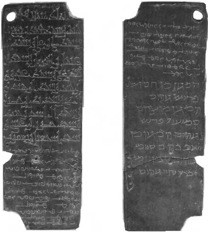
Up to the beginning of the 10th century CE, Ays were the dominant powers in Kerala. The Ay kings ruled from Thiruvalla in the North to Nagercoil in the South. Ptolemy mentions this as from Baris (Pamba River) to Cape Comorin "Aioi" (Kanyakumari).[11] By 12th century, we get the picture from the Thiruvalla copper plates, which are voluminous records that centre around the social life around the temple.[11] The society The Thiruvalla temple had a large Vedic learning school (actually comparable to modern university) ("Thiruvalla salai"), which was one of the foremost learning centres[13] in Kerala. The Thiruvalla salai was one of the richest among the Vedic schools of Kerala, and according to the copper plates, the pupils of the school were fed with 350 nazhis of paddy every day,[13] which shows the vastness of its student population. Thiruvalla held a very eminent position among the spiritual and educational centres in ancient times. The Sri Vallabha Temple was one of the wealthiest temples of ancient Kerala, as is evident from the inscriptions in the plates. The part of the temple land required to 'feed the Brahmins' required 2.1 million litres of rice seeds, and for the "maintenance of the eternal lamps" required more than 340,000 litres of paddy seed capacity.[14] Due to the length, the antiquity and the nature of the language, Thiruvalla copper plates form the "First book in Malayalam", according to Prof. Elamkulam.[15]
Early Modern period
The rulers of Thiruvalla now belonged to the Thekkumkoor Dynasty, which had one of its headquarters at Idathil near Kaavil Temple. Idathil (Vempolinadu Edathil Karthavu)[16] was the family name of the Thekkumkoor kings. Today's Paliakara Palace is a branch of Lakshmipuram Palace of Changanacherry, which is a branch of Alikottu Kovilakam of Pazhancherry in Malabar. Similarly, Nedumpuram Palace is a branch of Mavelikkara Palace is an heir to the Valluvanad tradition of South Malabar.
The Thekkumkoor kings lost their control in the course of time and Vilakkili (വിലക്കിലി) Nampoothiris were rulers in 1752–53 when Anizham Thirunal Marthanda Varma, the king of Travancore, seized it in a bloody battle in which the ruler was killed, though some dispute it, saying the surrender was peaceful as the Namboothiris were not naive to challenge the mighty army of Ramayyan, the shrewd and sadistic Dalava (ദളവ)- head of administration and advisor – of Travancore.[6]
Politics
The current Chairperson of the Municipality is Cherian Polachirackal and the vice-chairman is Sreerenjini S Pillai for 2018–2020.[17]
Thiruvalla's assembly constituency is part of the newly formed Pathanamthitta (Lok Sabha constituency).[18] The current MLA is Adv. Mathew T Thomas. Current MP Pathanamthitta (Lok Sabha constituency) is Anto Antony.
Religion

The city inside the modern municipal limits has an almost equal number of Christians (48.03%) and Hindus (46.92%). Muslims form 4.80% of the population.[19]

Thiruvalla is home to the Sree Vallabha Temple which is the only one of its kind in the State to have Kathakali performed as a ritual offering every night.[20]
Sports
The popular sports in Thiruvalla are football and cricket. The football history of Thiruvalla can be traced back to the legendary footballer from Thiruvalla, Thomas Varghes, called "Tiruvalla Pappan". He represented India in the London Olympics of 1948, and is described as one of the best defenders of 40's – 50's from India.[21] Today, Thiruvalla hosts many district and state-level football and cricket tournaments. There is a stadium in Thiruvalla maintained by the Thiruvalla Municipal Council. This is the venue for most of the tournaments. It is also called "Prithi stadium".[22]
Indoor Cricket
The Kerala Cricket Association has set up the world-class indoor cricket stadium complex in Thiruvalla, with world-class facilities, with 24-7 practising facilities. The facility is adjacent to the Thiruvalla Municipal stadium and is constructed on 8000 square feet, on 50 cents of land. The facility also houses a library, multi-gym, board room, KCA district office, and a conference hall. Specially made natural grass wicket is the specialty of the practicing nets in the courtyard. This indoor cricket facility is perhaps, the first of its kind in the state.[23]
Food and other cultural activities
Thiruvalla hosts cultural events including flower shows[24] and food fests.[25] Thiruvalla has become a destination for new restaurants and food delivery services like Swiggy and Zomato.[citation needed]
Notable persons
- Poykayil Yohannan, social activist, poet
- Vennikkulam Gopala Kurup, poet
- Abraham Kovoor, hypnotherapist and rationalist
- Abu Abraham, cartoonist
- Dr. M.M. Thomas, former Governor of Nagaland
- Baselios MarThoma Didymos I, Malankara Metropolitan and Catholicos of Malankara Orthodox Syrian Church
- Babu Thiruvalla, movie director and producer
- Blessy, movie director
- C. K. Ra, artist
- C.P. Mathen, banker and founder of the Quilon Bank
- C J Kuttappan, folklore artist
- Col. Jojan Thomas, military officer
- John Abraham, movie director
- K. G. George, movie director
- Kakkanadan, novelist and writer
- Mathew T. Thomas, politician
- K. C. John, former General President of India Pentecostal Church of God
- M. G. Soman, movie actor
- Nayanthara (Diana Mariam Kurian), movie actress
- Shalini, actress
- Kaveri, movie actress
- Meera Jasmine (Jasmine Mary Joseph), movie actress
- Nadiya Moythu, movie actress
- Parvathy Jayaram (Ashwathy Kurup), movie actress
- Oormila Unni (actress), movie actress
- Sreeja Chandran, actress
- Kaviyoor Ponnamma, actress
- Kaviyoor Sivaprasad, film director
- Sidhartha Siva, actor, director
- Kailash, movie actor
- Rajeev Pillai, movie actor
- Sajeev John, physicist
- Vishnu Vinod, cricketer
- Anna Rajam Malhotra, Indian Administrative Service officer
See also
- Edathua
- Thakazhy
- Mavelikara
- Chengannur
- Changanassery
- Adoor
- Kozhencherry
References
- "BOT experiment of KSRTC faces huge loss". Mathrubhumi. Retrieved 12 April 2014.
- "KSRTC's parasitism bleeding KTDFC". The Times of India. Retrieved 22 January 2021.
- "Census of India: Search Details". Archived from the original on 18 May 2015.
- "Efforts on to give facelift to Thiruvalla". The Hindu. 17 December 2015. ISSN 0971-751X. Retrieved 20 March 2016.
- "Where Kathakali is a daily affair". The Hindu. 11 August 2006. ISSN 0971-751X. Retrieved 25 August 2018.
- Shree Vallabha Mahakshethra Charitham, P. Unnikrishnan Nair
- "KISSAN – Kerala". kissankerala.net. Retrieved 20 March 2016.
- "Climate: Thiruvalla - Climate graph, Temperature graph, Climate table - Climate-Data.org". en.climate-data.org. Retrieved 20 March 2016.
- "Thiruvalla". native planet. Retrieved 16 January 2020.
- "Indus Civilisation and Tamil Language – Part 03", page 34. http://210.212.62.26/pdf_files/books/Indus%20civilization%20and%20tamil%20language%20part%20003.pdf
- Menon, A. Sreedhara (1 January 2007). A Survey of Kerala History. DC Books. ISBN 9788126415786.
- Library, John Rylands (1 January 1967). Bulletin of the John Rylands Library. Kraus Reprint.
- Cultural Heritage of Kerala. D.C. Books. 1 January 2008. ISBN 9788126419036.
- Joseph, George Gheverghese (10 December 2009). A Passage to Infinity: Medieval Indian Mathematics from Kerala and Its Impact. SAGE Publications India. ISBN 9788132104810.
- Congress, Indian History (1 January 1970). Proceedings of the Indian History Congress.
- P. Shungoonny Menon, A history of Travancore (first edition: 1878, new edition: 1983), page 130 and 131, ISBN 978-81-7020-040-6
- "Council". Thiruvalla Municipality. Retrieved 29 October 2018.
- "ORDER NO. 9 – TABLE A & B – ASSEMBLY AND PARLIAMENTARY CONSTITUENCIES AND THEIR EXTENT" (PDF). Kerala. DELIMITATION COMMISSION OF INDIA. Retrieved 31 May 2005.
- Census of India – Thiruvalla City population Religion data
- "Thiruvalla Town". keralatourism.org. Retrieved 16 January 2020.
- "This Tiruvalla Defender Stood Like a Wall in London Olympics". The New Indian Express. Retrieved 20 March 2016.
- "Untitled Document". cricketarchive.com. Archived from the original on 31 March 2016. Retrieved 20 March 2016.
- "World-class indoor cricket facility for Thiruvalla". The Hindu. 9 September 2015. ISSN 0971-751X. Retrieved 20 March 2016.
- Flower show thiruvalla 2020, Pushpotsav Thiruvalla, Pushpamela, Pushpamela Thiruvalla, 2020, retrieved 26 April 2022
- Staff Reporter (10 January 2012). "School children organises unique food fest in Thiruvalla". The Hindu. ISSN 0971-751X. Retrieved 26 April 2022.
External links
Places adjacent to Thiruvalla | ||||||||||||||||
|---|---|---|---|---|---|---|---|---|---|---|---|---|---|---|---|---|
| ||||||||||||||||
Travancore region | ||
|---|---|---|
| Districts |
|  |
| Towns and cities |
| |
Authority control | |
|---|---|
| General |
|
| National libraries | |
Другой контент может иметь иную лицензию. Перед использованием материалов сайта WikiSort.org внимательно изучите правила лицензирования конкретных элементов наполнения сайта.
WikiSort.org - проект по пересортировке и дополнению контента Википедии