world.wikisort.org - India
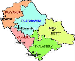
Taliparamba taluk is one of the five taluks in Kannur district in the state of Kerala, India.[1] It borders Payyanur Taluk in the north, Kannur taluk and Thalassery taluk in the south and Iritty taluk in the east. It is a revenue division for the ease of administrative purposes, and is headquartered in Taliparamba. Most government offices are in the Mini Civil Station in Taliparamba. Taliparamba taluk consists of Taliparamba Municipality, Anthoor Municipality, Sreekandapuram Municipality and 15 surrounding panchayats.
Taliparamba taluk
Thaliparamba | |
|---|---|
Taluk | |
 Taluks of Kannur | |
 Taliparamba taluk Location in Kerala, India  Taliparamba taluk Taliparamba taluk (India) | |
| Coordinates: 12°05′30″N 75°26′29″E | |
| Country | |
| State | Kerala |
| District | Kannur |
| Government | |
| • Type | Taluk |
| • Body | Taliparamba taluk |
| • Tehsildar | E. M. Reji |
| Area | |
| • Total | 825.29 km2 (318.65 sq mi) |
| Population (2011) | |
| • Total | 481,746 |
| • Density | 580/km2 (1,500/sq mi) |
| Languages | |
| • Official | Malayalam, English |
| Time zone | UTC+5:30 (IST) |
| PIN | 670xxx |
| Telephone code | 0460 |
| Vehicle registration | KL 59 |
| Nearest city | Kannur |
| Lok Sabha constituency | Kannur |
| Vidhan Sabha constituency | Taliparamba, Irikkur |
Constituent villages
Taliparamba taluk has 28 villages.[2]
- Alakode, Anthoor, Cheleri, Chengalayi
- Chuzhali, Eruvessi, Irikkur, Kayaralam
- Kolachery, Kooveri, Kurumathur, Kuttiattoor
- Kuttiyeri, Malapattam, Maniyoor, Mayyil
- Morazha, Nediyanga, New Naduvil, Panniyoor
- Pariyaram, Pattuvam, Payyavoor, Sreekandapuram
- Taliparamba, Thimiri, Udayagiri and Vellad
Demographics
Religions in Taliparamba Subdistrict (2011)[3]
As of 2011 Census, Taliparamba taluk had a population of 764,888 where 365,811 are males and 399,077 are females. The average sex ratio was 1091. 36.3% of the population lives in urban areas and 63.7% in rural areas. 11% of the population in the taluk was under 6 years of age. The average literacy rate was 93.85%.[4]
Geography
Taliparamba taluk consists of highland and midland regions including rubber, pepper, cashew and coconut plantations. It has predominantly agrarian economy.
References
- "Villages(132) | Kannur District , Government of kerala | India". kannur.nic.in. Retrieved 16 September 2020.
- "VILLAGE OFFICES IN TALIPARAMBA TALUK" (PDF). Government of India. Retrieved 16 September 2020.
- "Religion – Kerala, Districts and Sub-districts". Census of India 2011. Office of the Registrar General.
- Government of India (2014–15), District Census Handbook – Kannur (Part-B) 2011 (PDF), Directorate of Census Operations, Kerala
Другой контент может иметь иную лицензию. Перед использованием материалов сайта WikiSort.org внимательно изучите правила лицензирования конкретных элементов наполнения сайта.
WikiSort.org - проект по пересортировке и дополнению контента Википедии