world.wikisort.org - India
Iritty is a Municipality and a Taluk of Kannur district in Kerala State, India.[3] The town is the main market place for the farmer communities in the surrounding regions. Iritty is known as The Coorg Valley in God's Own Country. Iritty is one of the fastest upcoming towns in Kerala with the distance of 20 km (12 mi) from Kannur International Airport and one among five taluks in Kannur district. Iritty is one of the major towns lies between Coorg and Kannur international airport -Mattanur.[4]
This article needs additional citations for verification. (June 2014) |
Iritty | |
|---|---|
Municipality | |
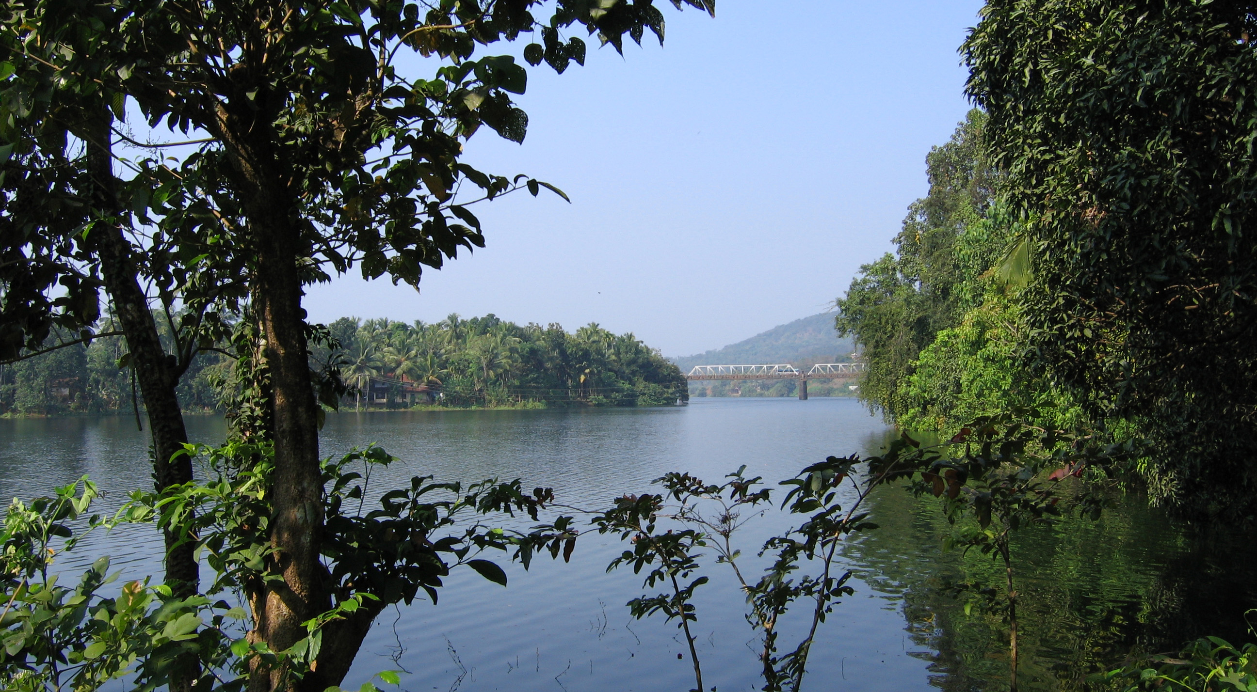
 View of Iritty Bridge built in 1933 | |
 Iritty Location in Kerala, India  Iritty Iritty (India) | |
| Coordinates: 11.9819°N 75.6703°E | |
| Country | |
| State | Kerala |
| District | Kannur |
| Municipality Established | 1st April 2016 |
| Taluk | Iritty |
| Government | |
| • Type | Municipal Council |
| • Municipal Chairman | Sreelatha K |
| • Deputy Superintendent of Police | Sajesh Vazhalappil [1] |
| Area | |
| • Total | 45.84 km2 (17.70 sq mi) |
| Elevation | 39 m (128 ft) |
| Population (2011) | |
| • Total | 40,369 |
| • Density | 880/km2 (2,300/sq mi) |
| Languages | |
| • Official | Malayalam, English |
| Time zone | UTC+5:30 (IST) |
| Telephone code | 91 (0)490 |
| ISO 3166 code | IN-KL |
| Vehicle registration | KL-78 |
| Sex ratio | 1066 ♂/♀ |
| Nearest city | Kannur |
| Assembly constituency | Peravoor |
| Lok Sabha constituency | Kannur |
Location

Iritty is located on the banks of Bavali river, which originates from the Wayanad passes.[5] Iritty is situated on the Thalassery-Coorg-Mysore highway or State Highway 30 (Kerala) between Mattanur and Virajpet. Nearby smaller towns are Padiyoor, Peravoor, Kakkayangad, Aralam, Keezhppally, Vallithode, Karikkottakary, Angadikadavu, Anappanthy, Edoor, Ulikkal, Vattiyamthode, Mattara, Manikkadavu, Kilyianthara, Punnad, Charal, Edapuzha, Uruppumkutti, Vilakkode and Chavassery.
Aralam Wildlife Sanctuary is situated 8 kilometres (5 mi) from Iritty.
Geography
Iritty is surrounded by hills. A river flowing through Iritty is more commonly known as Iritty Puzha (Iritty River). There is a steel girder bridge, built in 1933, over the river. There is a dam in the place Pazhassi for irrigation purpose named 'Pazhassi Dam' which is almost 10 km from the town. Wayanad tourist destinations are near from this place. The nearby areas are depending on Iritty for most of their shopping. Payam, Aralam, Punnad, Vallithode, Kilyianthara, Kondambra, Kolikkadavu, Keezhur, Ulickal, Vattiyamthode, Mattara, Kalanki, Manikadave, Manippara Perumpally, Nuchiyad, Vayathoor, Edoor, Peratta, Karikottakari, Angadikadave, Puravayal, Kootupuzha, Charal, Alathupramba, Thermala, Urathoor, Vilakkode, Madathil etc. are the nearby small towns around.
Steel bridge
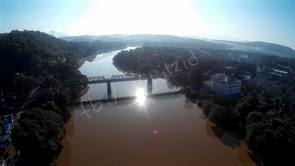
The steel bridge in Iritty is a 10-ton bridge constructed in 1933 by the British authorities to connect the towns of Kodagu and Thalassery.[6] It was designed by George Anderson of the Institution of Civil Engineers.[7][8] A July 2015 death of a man after being accidentally wedged between the handrail and a private bus raised concerns about the bridge's age.[6]
Administration
Iritty was initially part of Keezhur-Chavassery Panchayat and upgraded to a Municipality on 1 November 2015. The Municipal town is divided into 33 wards. K Sreekala is the present municipal chairperson of Iritty. The current ruling party of Iritty Municipality is LDF.[9]
Iritty Municipality is a part of Peravoor Assembly Constituency under Kannur Loksabha Constituency.[10]
Iritty established as a Taluk headquarters since March 2013 when Kerala government declared new taluks for the state. Iritty taluk falls under Thalassery Revenue division.[11]
Villages in Iritty Taluk
Iritty Taluk has 20 villages
- Aralam, Ayyankunnu, Chavasseri and Kalliad
- Kanichar, Karikkottakari, Keezhur and Kelakam
- Kolari, Kottiyoor, Manathana and Muzhakkunnu
- Nuchiyad, Padiyoor, Payam and Pazhassi
- Thillankeri, Vayathur, Vellarvalli and Vilamana
Etymology

Iritty, one of the beautiful hill side towns in the north Malabar of Kerala. The beauty of Iritty lies together with the unique rivers, streams, green hills and valleys. The main Streams of Iritty river are by the three rivers such as Bavali river, Aralam river and Barapuzha (Veni river). Before the name 'Iritty,' made the first cry, this land was nourished by two main rivers, one Barapuzha and Bavalipuzha . People started calling both the rivers confluence as Iratta puzha (Double River & 'Puzha' means River ), and in course of time the land became Iritty.[12]
Climate
Iritty has a tropical monsoon climate (Am) with little to no rainfall from December to March and heavy to extremely heavy rainfall from April to November.
| Climate data for Iritty | |||||||||||||
|---|---|---|---|---|---|---|---|---|---|---|---|---|---|
| Month | Jan | Feb | Mar | Apr | May | Jun | Jul | Aug | Sep | Oct | Nov | Dec | Year |
| Average high °C (°F) | 31.6 (88.9) |
32.5 (90.5) |
33.6 (92.5) |
33.9 (93.0) |
33.2 (91.8) |
29.9 (85.8) |
28.6 (83.5) |
29.0 (84.2) |
29.7 (85.5) |
30.5 (86.9) |
31.0 (87.8) |
31.2 (88.2) |
31.2 (88.2) |
| Daily mean °C (°F) | 26.5 (79.7) |
27.5 (81.5) |
28.9 (84.0) |
29.8 (85.6) |
29.4 (84.9) |
26.9 (80.4) |
26.0 (78.8) |
26.2 (79.2) |
26.6 (79.9) |
27.0 (80.6) |
26.9 (80.4) |
26.3 (79.3) |
27.3 (81.2) |
| Average low °C (°F) | 21.4 (70.5) |
22.6 (72.7) |
24.3 (75.7) |
25.7 (78.3) |
25.6 (78.1) |
23.9 (75.0) |
23.4 (74.1) |
23.5 (74.3) |
23.5 (74.3) |
23.6 (74.5) |
22.9 (73.2) |
21.5 (70.7) |
23.5 (74.3) |
| Average precipitation mm (inches) | 3 (0.1) |
4 (0.2) |
12 (0.5) |
85 (3.3) |
283 (11.1) |
867 (34.1) |
1,332 (52.4) |
711 (28.0) |
329 (13.0) |
279 (11.0) |
106 (4.2) |
23 (0.9) |
4,034 (158.8) |
| Source: [13] | |||||||||||||
Transportation
Iritty lies at an equal distance from the nearby cities of Kannur, Thalassery, Mahe, Taliparamba and Virajpet (Karnataka State). The proposed Kannur Mysore National Highway or SH 30 passes through Iritty connecting Thalassery, Mattanur Airport and Kodagu. This was initially called the TC Road by the British. This highway is used by interstate bus services plying to Madikeri, Mysore and Bangalore.[14]
SH 36 connects Iritty with Taliparamba that gives access to other towns like Irikkur and Sreekandapuram.[15]
Keezhur is the starting point of Iritty town. This place is well-connected by road from both Kannur and Thalassery.[16] There are frequent buses from Iritty and to both these places and to several places across Kerala including Kottayam, Cochin (Ernakulam), Mangalore, Kasaragod, Panathur, Kanhangad, Cherupuzha, Wayanad and Kozhikode. There is no railway line, with the nearest railway stations at Kannur and Thalassery. The nearest airport is Kannur International Airport, at Mattannur is located 19.5 km south-west of Iritty.
Commerce
Iritty is one of the major towns of the Kannur district. With nearby villages which produce cash crops and plantation crops, Iritty is a major commercial town too. It is one of the growing towns in the district. Iritty is famous for cash crops such as pepper, rubber and cashew nuts, some of which are sold under regional brands in various auction houses and commodities markets.
Iritty is primarily a trading town. Iritty is headquarters to several State Government offices. Most of these offices have jurisdiction over nearby towns like Mattanur and Peravoor.[17]
Institutions / Government Firms in Iritty
- Fire Station Iritty
- Taluk office iritty
- SIET CD MART (Project under Dept of Education - Kerala), Nr Fire Station, Iritty
- Labour Office NP Road Iritty
- Sub Treasury, Falcon Plaza Iritty
- State Ware House Iritty
- KSFE New Bustand Iritty
- SUB RT OFFICE, FALCON PLAZA IRITTY
- Co-operative society assistant registrar office, Iritty

Hospitals
- Amala Multi Speciality Hospital, Keezhur
- Sky Super Speciality Hospital, Iritty.
- Thulasi Malabar Hospital, Iritty.
- Karunya Hospital, Iritty.
- Nikhil Hospital, Iritty.
- Reena Nursing Home.
- Christu Raja Dental Clinic
- Asokan's Dental Clinic.
- ECHS Poly Clinic, Iritty
- Govt.Taluk Hospital, Iritty
- S M Hospital, Iritty
- R VISION EYE HOSPITAL, IRITTY.
Higher Education/ Technical Education/ IT Education/ Career Guidance
- Tech Info Psc, iritty, PSC,SSC, RAILWAY,UPSC Coaching
- Mahatma Gandhi College, Iritty, affiliated to Kannur University, Affiliated to NAAC with 'A' grade
- Amala School of Nursing, affiliated with Indian Nursing Council
- Don Bosco College, Angadikadavu, a self-financing college affiliated to Kannur University
- PRAGATHI career guidance & Bank coaching, Nerampokk road Iritty. Topest PSC coaching centre in Kannur district
- EMS Memorial College of Applied Science, Iritty
- Majlisu Nashathi Sunniyya, Uliyil
- Sree Narayana Guru College of Arts and Science, Veerpad, Iritty
- De Paul College, Edathotty, Kannur University
- Ideal Arabic College, Narempara, Uliyil, affiliated to kannur university
- Pushparam ITI (Pvt.), Iritty
- MG ITI under Iritty Educational Society, Keezhur Kunnu, Iritty
- Chaithanya Institute of Engineering, Nerampoku Road, Iritty
- Nikhil School of Nursing
- Central Institute of education and Training, affiliated to Dept.of Technical Education, Govt.of kerala, NP Road Iritty
- Centre for Development of Imaging Technology (C-dit)
- Rutronix institute of Computer Education (Authorized Training Center Pravasi Edcucation )
- Sree Sankaracharya Computer Center, City Tower New Bus Stand Iritty
- Sac IT Education
- CIIT Computer Training Centre, Nr Canera Bank Iritty
- CIMAS Animation Campus, Falcon Plaza Iritty
- Educare Academy Iritty
- NORKA Roots Skill Development Centre, Nr Sub Treasury Iritty
- CGFT Garment Training Centre Iritty
- UNIVERSAL College N P Road Iritty
- Pragathi Vidhyanikethan Nerampoke Road Iritty [18]
Govt/ Aided/ Unaided Schools
- Iritty Higher Secondary School.
- Govt. UP school Vilakkode
- Global India Public School (GIPS) Vilakkode
- St. Thomas Higher Secondary School Manikkadavu
- St. Mary's Higher Secondary School, Edoor.
- St. Sebastian's Higher Secondary School, Velimanam.
- GHSS Aralam.
- St. Joseph's Higher secondary School, Kunnoth.
- Sacred Heart Higher Secondary School, Angadikkadavu.
- Govt. Higher Secondary School, Pala
- GHSS, padiyoor
- St.Thomas HSS, Kiliyanthara
- Govt. L.P. School, Peratta
- St. Joseph's English Medium School, Peratta
- Kavumbady Higher Secondary School
- GHSS Chavassery.
- St. Thomas High School, Karikkottakari.
- Govt. High School, Perinkari
- Zuhra UP School, Vellarivayal.
- St.Antony's U.P.School, Peratta
- Vazhunnavars UPS, Keezhur
- SDA English School Keezhur, Iritty
- St.John Baptist EHSS, Kadathumkadavu, Iritty
- CMI Christ School, Iritty
- Benhill English School, Iritty
- G.U.P School uliyil
- Vanivilasam L.P School uliyil
- Navajyothi English medium (CBSE)
- Higher Secondary School, Edathotty [19]
Pilgrim Centres & Religious Centres
- Sharon Fellowship Church, Vallithode (Pentecostal Church)
- The India Pentecostal church of God (IPC), Kolithattu
- Full Gospel Pentecostal church, Vallithode
- Bethel Assemblies of God church, veerpad (Pentecostal church)
- Assemblies of God church, Perinkiri (Pentecostal church)
- Assemblies of God church, Arabi (Pentecostal church)
- St. Mary's Church Mattara
- Vilakkode sree nittoor Shiva temple
- Sree Adiyerimadam Devi Temple, Aralam. Phone: 0490 2500400, 9745845100 http://www.adiyerimadam.com
- Sree Kairathi Kiratha Temple Iritty
- Sree Mahavishnu Temple Keezhur
- Sree Mahadeva Temple Keezhur
- Sree Puthiya Bhagavathi Kavu, Peumparamba
- Sree Mundayamparamba Tharakkumeethal Bhagavathi Temple
- Sree Vairee Khathakan kshethram, Payancheri
- Sree Koorumba Bhagavathi temple Payancheri, Iritty
- Sree Kavoottu Paramba Ganapati-Mahadeva Temple, Keezhur kunnu
- Sree Muthappan madappura, vallithode
- St. Mary's Forane Church Edoor
- St.Josephs Church Iritty
- St. George Church Puravayal
- Sacred Heart Church Angadikkadavu
- ST. SEBASTIAN CHURCH NELLIKKAMPOIL
- St. Sebastian's Church, Madathil
- ST. Mary's church Thermala
- ST. Thomas church karikkottakary
- ST. Mary's church edoor
- ST. Sebastian's church velimanam
- ST. John's C.S.I church, vallithode
- St. Mary's Church, Kilianthara
- St. Alphonsa church, Perinkari
- St. Mary's and St. Thomas malakara Syrian orthodox church Kilianthara
- Valiyajuma palli Uliyil
St Chavara Church Keezhpally
- St. Antony's Church, Peratta
Tourism
Iritty and the surrounding areas have a choice of tourism attractions.
- Aralam Wildlife Sanctuary
- Pazhassi Dam and garden
- Kanjirakkolly waterfalls
- Perumparamba Mahatma Gandhi Park
- Coorg valleys
- Palchuram
- Elapeedika
- Krishnagiri river and Barapole hydroelectric project
- Central State farm at Aralam
- Steel girder bridge at Iritty built by British
- Chitravattam
Notable People
- Tintu Luka, an Indian athlete[20]
See also
- Ambayathode, Anappanthy, Angadikadavu and Aralam
- Ayyankunnu, Edoor, Elapeedika and Kanichar
- Karikkottakary, Keezhpally, Keezhur and Keezhurkunnu
- Kelakam, Kiliyanthara, Koloyad, Kottakkuthazhe, Kottiyoor and Kottiyoor Temple
- Kottiyoor Vysakha Mahotsavam, Kunnathoor Padi, Malayampadi and Manathana
- Manikkadavu, Manippara, Muzhakkunnu, Nedumpoil and Nuchiyad
- Peratta, Peravoor, Punnad, Tholambra, Ulikkal, Uruppumkutti and Vallithode
- Vaniyappara, Vattiyamthode, Vayathur and Vekkalam
- Velimanam, Vellarvelly Chungakkunnu and Vilamana, Vilakkode
References
- "Law and Order - Kannur Rural". keralapolice.gov.in.
- "iritty elevation map". topographic-map.com.
- "New Municipalities of Kerala : Election Results". Trend Kerala – Democracy. Archived from the original on 12 March 2016. Retrieved 20 March 2016.
- "City Profile in PMAY - Iritty".
- "Iritty basic information".
- Nazeer, Mohamed (2 August 2015). "Man's death puts spotlight on safety of Iritty bridge". The Hindu. ISSN 0971-751X. Retrieved 6 December 2015.
- "Method of Erecting the Iritty Bridge, Malabar". The Railroad Gazette. Vol. 25. 24 March 1893. p. 224.
- "Method of Erecting the Iritty Bridge Malabar". The Railway Engineer. Vol. 14. June 1893. pp. 174–175.
- "LDF retains power in Iritty Municipality". The Hindu. 29 December 2020.
- "Assembly Constituencies - Corresponding Districts and Parliamentary Constituencies" (PDF). Kerala. Election Commission of India. Archived from the original (PDF) on 4 March 2009. Retrieved 18 October 2008.
- "12 new taluks to be formed in Kerala". The Hindu. 21 March 2013. Archived from the original on 15 November 2017.
- "Story behind name".
- "Iritty climate: Average Temperature, weather by month, Iritty weather averages - Climate-Data.org". en.climate-data.org. Retrieved 25 December 2021.
- "Kannur-Mysuru corridor to be made NH". The Hindu. Retrieved 26 July 2017.
- "Kerala State Highways". Kerala PWD Department. Archived from the original on 1 December 2010. Retrieved 13 May 2016.
- "Iritty More information of Iritty".
- "Kannur International Airport". Archived from the original on 2 August 2018. Retrieved 6 September 2014.
- "Higher Educational Institutes in Kannur University".
- "schoolist". www.dhsekerala.gov.in.
- "Road to Rio: Tintu Luka, India's best bet to end athletics medal wait at Olympics". The Indian Express. 22 July 2016. Retrieved 17 August 2016.
External links
 Iritty travel guide from Wikivoyage
- Website of Iritty
Другой контент может иметь иную лицензию. Перед использованием материалов сайта WikiSort.org внимательно изучите правила лицензирования конкретных элементов наполнения сайта.
WikiSort.org - проект по пересортировке и дополнению контента Википедии