world.wikisort.org - India
Gondia (also spelled Gondiya) is a city and municipal council in the Indian state of Maharashtra which serves the administrative headquarters of the eponymous administrative district.[4] Gondia is also known as Rice City due to the abundance of rice mills in the area.[5] Tirora (33km) is only nearby city to Gondia. Gondia Airport is only airport in district.
This article needs additional citations for verification. (July 2022) |
Gondia
Gondiya | |
|---|---|
City | |
| Nickname: Rice city | |
 Gondia (rice city) | |
 Gondia Location in Maharashtra, India  Gondia Gondia (India) | |
| Coordinates: 21.4598°N 80.195°E | |
| Country | India |
| State | Maharashtra |
| District | Gondia |
| Government | |
| • Type | Municipal Council |
| • Body | Gondia Municipal Council |
| • District collector[1] | Nayana A. Gunde, IAS |
| • District Police Superintendent | Vishwa Pansare IPS[2] |
| Area | |
| • Total | 55 km2 (21 sq mi) |
| • Rank | 1st in Gondia District
East Vidarbha: 2nd Vidarbha: 5th |
| Elevation | 300 m (1,000 ft) |
| Population (2011) | |
| • Total | 132,821 |
| • Density | 2,400/km2 (6,300/sq mi) |
| Demonym | Gondiakar |
| Language | |
| • Official | Marathi[3] |
| Time zone | UTC+5:30 (IST) |
| PIN | 441601,441614 |
| Telephone code | +91-07182 |
| Vehicle registration | MH-35 |
| Sex ratio | 991 per 1000 male. ♂/♀ |
| Nearest city | Tirora (33km) |
| Website | gondia |
History
The region is named after the Gondi people, an Adivasi group in central India.
During British rule in India, the Great Famine of 1876–78 provided an opportunity for the construction of a 150-kilometre-long (93 mi) metre-gauge rail link called the Nagpur Chhattisgarh Railway, connecting Nagpur with Rajnandgaon. Gondia railway station was created when this line began operation in December 1888. Bengal Nagpur Railway (BNR) was formed in 1887 to upgrade and extend this line, and in 1902 BNR was contracted to provide a railway line from Gondia to Jabalpur with branches from Nainpur to Mandla as well as Nainpur to Seoni and Chhindwara. With these links and the commerce they brought, Gondia grew and prospered.[6]
Geography
Climate
| Climate data for Gondia (1981–2010, extremes 1946–2012) | |||||||||||||
|---|---|---|---|---|---|---|---|---|---|---|---|---|---|
| Month | Jan | Feb | Mar | Apr | May | Jun | Jul | Aug | Sep | Oct | Nov | Dec | Year |
| Record high °C (°F) | 34.5 (94.1) |
38.5 (101.3) |
42.5 (108.5) |
46.1 (115.0) |
47.5 (117.5) |
47.5 (117.5) |
44.2 (111.6) |
38.4 (101.1) |
39.4 (102.9) |
38.0 (100.4) |
35.7 (96.3) |
35.1 (95.2) |
47.5 (117.5) |
| Average high °C (°F) | 28.5 (83.3) |
31.2 (88.2) |
35.9 (96.6) |
40.3 (104.5) |
42.3 (108.1) |
37.9 (100.2) |
31.5 (88.7) |
30.6 (87.1) |
32.1 (89.8) |
32.6 (90.7) |
30.9 (87.6) |
28.9 (84.0) |
33.6 (92.5) |
| Average low °C (°F) | 13.2 (55.8) |
15.6 (60.1) |
19.9 (67.8) |
24.2 (75.6) |
27.7 (81.9) |
26.8 (80.2) |
24.1 (75.4) |
24.0 (75.2) |
23.6 (74.5) |
21.4 (70.5) |
16.6 (61.9) |
12.6 (54.7) |
20.8 (69.4) |
| Record low °C (°F) | 6.6 (43.9) |
6.7 (44.1) |
11.4 (52.5) |
11.6 (52.9) |
13.8 (56.8) |
20.4 (68.7) |
19.8 (67.6) |
18.3 (64.9) |
19.2 (66.6) |
13.3 (55.9) |
8.5 (47.3) |
5.0 (41.0) |
5.0 (41.0) |
| Average rainfall mm (inches) | 24.3 (0.96) |
22.9 (0.90) |
13.9 (0.55) |
8.8 (0.35) |
10.6 (0.42) |
180.5 (7.11) |
386.1 (15.20) |
374.5 (14.74) |
177.6 (6.99) |
46.5 (1.83) |
13.6 (0.54) |
11.4 (0.45) |
1,270.7 (50.03) |
| Average rainy days | 1.4 | 1.7 | 1.4 | 0.9 | 1.0 | 8.6 | 16.2 | 16.8 | 8.9 | 3.2 | 0.6 | 0.6 | 61.4 |
| Average relative humidity (%) (at 17:30 IST) | 48 | 37 | 30 | 25 | 25 | 50 | 73 | 78 | 71 | 57 | 51 | 47 | 50 |
| Source 1: India Meteorological Department[7][8] | |||||||||||||
| Source 2: Government of Maharashtra[9] | |||||||||||||
Location
Gondia is very close to the state of Madhya Pradesh, Chhattisgarh and is considered the gateway to Maharashtra from central and eastern India. Tirora is only nearby city. Gondia municipal council was established in 1920. At that time Gondia had only 10 wards population up to 20,000 and an area of 7.5 km2. Gondia has 42 wards, as well as population nearing up to 2 lakhs. The urbanization has crossed municipal limits merging into nearby villages like Kudwa, Katangi, Fulchur, Nagra, Karanja, Murri, Pindkepar, and Khamari. The Ministry of Urban Development has recently[when?] announced to merge 20 nearby villages into Gondia to give the city status of Municipal Corporation. It is connected with National Highway 543 and 753.
Economy
This section needs expansion. You can help by adding to it. (March 2018) |
The city has a large number of rice mills.[10][11]
Transportation
Road
This section needs expansion. You can help by adding to it. (March 2018) |
The Mumbai–Nagpur–Kolkata Road is the only national highway passing through the district, covering a total distance of 99.37 km (62 mi). Gondia is situated about 170 km by road from Nagpur of Vidarbha region. The district has road links to adjoining districts Chandrapur, Bhandara, Nagpur. The city is well connected by roads. It takes around 4 hours journey from Nagpur by State Transport Bus to reach Gondia. Gondia has bus connectivity to Jabalpur, Nagpur, Raipur and Hyderabad.
Rail
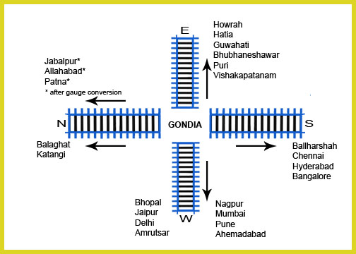
Gondia Junction railway station is a junction in Maharashtra, with heavy passenger and goods traffic. It is an A-Grade station.
It lies on the Howrah–Mumbai route. The station has seven platforms, each with potable water, tea stalls, benches and waiting sheds. There is also a fruit stall and a bookstall. The station is equipped with air-conditioned waiting rooms for passengers travelling by upper accommodation classes and a waiting hall for passengers travelling by lower accommodation classes.
The Gondia–Jabalpur Junction (Madhya Pradesh) section of South East Central Railway runs north–south, along the valley of the Wainganga River. The line was formerly narrow gauge (762 mm [2 ft 6 in]) along its entire length, but the section between Gondia and Balaghat was converted to broad gauge in 2005–2006,[12] connecting Balaghat to India's national broad-gauge network. Work is completed to convert the Balaghat–Jabalpur section to broad gauge as well.
Railway milestones for Gondia include:
- 1888 – Gondia Railway Station was opened to the public.
- 1901 – Satpura Express began first class service.
- 1903 – The first portion of Gondia–Nainpur was opened.
- 1905 – Nainpur–Gondia line was extended to Jabalpur.
- 1908 – Gondia–Nagbhir–Nagpur line was opened for traffic. Mr. Manson was an agent of BNR at that time.
- 1990-91 – Paniajob–Gondia and Gondia–Bhandara Road sections were electrified.[13]
- 1999 – Gauge-converted Gondia–Balharshah line opened.
- 2005 – Gauge-converted Gondia–Balaghat section opened.
Airport
Gondia Airport is situated near Kamtha village, 12 km (7.5 mi) from Gondia. This airstrip was built by the British in 1940, during World War II.[14] Initially run by the Public Works Department, it was taken over by the state-owned Maharashtra Industrial Development Corporation (MIDC) from August 1998[15] to December 2005, after which it has been operated by the Airports Authority of India (AAI). The airport's runway has been extended to 2,300 metres (7,500 ft) to accommodate Airbus A-320, Boeing 737 and similar aircraft.[16]
References
- "District Gondia - Collectorate". Retrieved 30 July 2019.
- ANI (27 December 2020). "Naxal hideout busted in Maharashtra's Gondia district, explosives recovered". Free Press Journal. Retrieved 21 January 2021.
- "52nd Report of the Commissioner for Linguistic Minorities in India" (PDF). nclm.nic.in. Ministry of Minority Affairs. Archived from the original (PDF) on 25 May 2017. Retrieved 29 March 2019.
- "गोंदिया संकेतस्थळ". gondia.nic.in. Retrieved 10 July 2022.
- "Gondia District Map". www.mapsofindia.com. 25 April 2013. Retrieved 19 January 2018.
- "The Roaring Journey" (PDF). secr.indianrailways.gov.in.
- "Station: Gondia Climatological Table 1981–2010" (PDF). Climatological Normals 1981–2010. India Meteorological Department. January 2015. pp. 293–294. Archived from the original (PDF) on 5 February 2020. Retrieved 5 April 2020.
- "Extremes of Temperature & Rainfall for Indian Stations (Up to 2012)" (PDF). India Meteorological Department. December 2016. p. M142. Archived from the original (PDF) on 5 February 2020. Retrieved 5 April 2020.
- "Climate and Seasons". Government of Maharashtra. Retrieved 5 April 2020.
- Behl, Manka (22 August 2016). "Rice mills at Gondia causing pollution". The Times of India. Retrieved 29 July 2022.
- "Promote fortified rice manufacturing plants, Centre tells Maharashtra". Business Line. 5 December 2021. Retrieved 29 July 2022.
- Railway Gazette International Supplement December 2007 p7
- "History of Electrification". IRFCA. Retrieved 10 November 2012.
- "Airstrips in Maharashtra". Maharashtra Public Works Department. Retrieved 1 April 2012.
- "MIDC airports". Archived from the original on 28 March 2012. Retrieved 30 January 2012.
- "Akola, Gondia next aviation hot spots". The Times of India. 27 November 2007. Archived from the original on 11 July 2012. Retrieved 30 January 2012.
Places adjacent to Gondia | |
|---|---|
Gondia district topics | ||
|---|---|---|
| History |
|  |
| Geography | ||
| Cities and towns | ||
| Transport |
| |
| Culture | ||
| Lok Sabha constituencies |
| |
| Vidhan Sabha constituencies |
| |
Largest city: Nagpur Second largest: Amravati | |
| Districts of Vidarbha |
|
| Cities with municipal corporations |
|
Portal:India | |
| |||||||||||||
| Topics |
| ||||||||||||
| Regions |
| ||||||||||||
| Divisions and Districts |
| ||||||||||||
| Million-plus cities in Maharashtra |
| ||||||||||||
| Other cities with municipal corporations |
| ||||||||||||
Portal:India | |||||||||||||
На других языках
[de] Gondia
Gondia, auch Gondiya, ist eine Stadt im Bundesstaat Maharashtra im Westen Indiens. Sie ist Verwaltungssitz des gleichnamigen Distrikts Gondia. Gondia wird als Municipal Council verwaltet. Von Gondia aus sind es nach Mumbai 950 Kilometer. Gondia liegt sehr nahe an den Bundesstaaten Madhya Pradesh und Chhattisgarh und gilt als Tor nach Maharashtra von Zentral- und Ostindien aus. Der Municipal Council Gondia wurde 1920 gegründet.- [en] Gondia
[ru] Гондия
Го́ндия (англ. Gondia, маратх. गोंदिया) — город в индийском штате Махараштра. Административный центр округа Гондия.Другой контент может иметь иную лицензию. Перед использованием материалов сайта WikiSort.org внимательно изучите правила лицензирования конкретных элементов наполнения сайта.
WikiSort.org - проект по пересортировке и дополнению контента Википедии