world.wikisort.org - France
Steenvoorde (French pronunciation: [stɛ̃vɔʁd]) is a commune in the Nord department in northern France.[2] Once part of the Seventeen Provinces of the Low Countries, Steenvoorde was the site of the beginning of the Beeldenstorm, or "Iconoclastic Fury." Today the city is known for its Géants du Nord, sculptures of giants that can be admired in summer festivals.[3]

Steenvoorde | |
|---|---|
Commune | |
 Town hall | |
 Coat of arms | |
Location of Steenvoorde  | |
 Steenvoorde  Steenvoorde | |
| Coordinates: 50°48′40″N 2°34′53″E | |
| Country | France |
| Region | Hauts-de-France |
| Department | Nord |
| Arrondissement | Dunkerque |
| Canton | Wormhout |
| Intercommunality | CC Flandre Intérieure |
| Government | |
| • Mayor (2020–2026) | Jean-Pierre Bataille |
| Area 1 | 29.82 km2 (11.51 sq mi) |
| Population | 4,429 |
| • Density | 150/km2 (380/sq mi) |
| Demonym | Steenvoordois |
| Time zone | UTC+01:00 (CET) |
| • Summer (DST) | UTC+02:00 (CEST) |
| INSEE/Postal code | 59580 /59114 |
| Elevation | 8–67 m (26–220 ft) (avg. 25 m or 82 ft) |
| 1 French Land Register data, which excludes lakes, ponds, glaciers > 1 km2 (0.386 sq mi or 247 acres) and river estuaries. | |
Geography
Climate
Steenvoorde has a oceanic climate (Köppen climate classification Cfb). The average annual temperature in Steenvoorde is 11.2 °C (52.2 °F). The average annual rainfall is 727.8 mm (28.65 in) with November as the wettest month. The temperatures are highest on average in July, at around 18.5 °C (65.3 °F), and lowest in January, at around 4.5 °C (40.1 °F). The highest temperature ever recorded in Steenvoorde was 40.8 °C (105.4 °F) on 25 July 2019; the coldest temperature ever recorded was −13.4 °C (7.9 °F) on 4 February 2012.
| Climate data for Steenvoorde (1991−2020 normals, extremes 2004−present) | |||||||||||||
|---|---|---|---|---|---|---|---|---|---|---|---|---|---|
| Month | Jan | Feb | Mar | Apr | May | Jun | Jul | Aug | Sep | Oct | Nov | Dec | Year |
| Record high °C (°F) | 15.3 (59.5) |
18.3 (64.9) |
24.1 (75.4) |
26.3 (79.3) |
31.8 (89.2) |
33.5 (92.3) |
40.8 (105.4) |
34.9 (94.8) |
33.3 (91.9) |
28.8 (83.8) |
19.9 (67.8) |
14.8 (58.6) |
40.8 (105.4) |
| Average high °C (°F) | 6.8 (44.2) |
7.3 (45.1) |
10.5 (50.9) |
15.0 (59.0) |
17.8 (64.0) |
20.8 (69.4) |
23.5 (74.3) |
22.9 (73.2) |
20.4 (68.7) |
15.7 (60.3) |
10.6 (51.1) |
7.5 (45.5) |
14.9 (58.8) |
| Daily mean °C (°F) | 4.5 (40.1) |
4.7 (40.5) |
7.0 (44.6) |
10.4 (50.7) |
13.3 (55.9) |
16.2 (61.2) |
18.5 (65.3) |
18.2 (64.8) |
16.0 (60.8) |
12.5 (54.5) |
8.1 (46.6) |
5.2 (41.4) |
11.2 (52.2) |
| Average low °C (°F) | 2.2 (36.0) |
2.0 (35.6) |
3.5 (38.3) |
5.7 (42.3) |
8.8 (47.8) |
11.6 (52.9) |
13.5 (56.3) |
13.5 (56.3) |
11.6 (52.9) |
9.2 (48.6) |
5.5 (41.9) |
2.9 (37.2) |
7.5 (45.5) |
| Record low °C (°F) | −10.9 (12.4) |
−13.4 (7.9) |
−6.8 (19.8) |
−2.6 (27.3) |
1.0 (33.8) |
4.9 (40.8) |
7.4 (45.3) |
7.8 (46.0) |
3.2 (37.8) |
−0.1 (31.8) |
−4.4 (24.1) |
−9.6 (14.7) |
−13.4 (7.9) |
| Average precipitation mm (inches) | 51.0 (2.01) |
54.0 (2.13) |
49.0 (1.93) |
32.6 (1.28) |
51.0 (2.01) |
52.5 (2.07) |
67.8 (2.67) |
81.6 (3.21) |
55.0 (2.17) |
70.0 (2.76) |
86.5 (3.41) |
76.8 (3.02) |
727.8 (28.65) |
| Average precipitation days (≥ 1.0 mm) | 11.1 | 10.5 | 9.5 | 7.2 | 9.3 | 7.7 | 9.4 | 10.7 | 8.0 | 10.9 | 13.6 | 13.1 | 120.9 |
| Source: Météo-France[4] | |||||||||||||
Heraldry
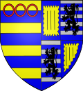 |
The arms of Steenvoorde are blazoned : Barry Or and azure, in chief in fess 3 annulets impaled with Quarterly 2&4: Or, 3 ?pallets couped? sable within a bordure engrailed azure; 2&3: Barry argent and azure, a lion sable.
|
See also
References
- "Populations légales 2019". The National Institute of Statistics and Economic Studies. 29 December 2021.
- INSEE commune file
- https://www.panoviews.net/STEENVOORDE/ville/ .Panoviews, le 1er annuaire de visite virtuelle à 360°
- "Fiche Climatologique Statistiques 1991-2020 et records" (PDF) (in French). Météo-France. Retrieved September 7, 2022.
External links
This Nord geographical article is a stub. You can help Wikipedia by expanding it. |
На других языках
[de] Steenvoorde
Steenvoorde, westflämisch Stêenvôorde, ist eine französische Gemeinde mit 4429 Einwohnern (Stand 1. Januar 2019) im Département Nord in der Region Hauts-de-France. Sie gehört zum Arrondissement Dunkerque und zum Gemeindeverband Flandre Intérieure. In Steenvoorde wird auch Westflämisch gesprochen.- [en] Steenvoorde
[es] Steenvoorde
Steenvoorde es una comuna del Flandes francés, situada entre Lille y Dunkerque. Administrativamente pertenece al arrondissement de Dunkerque, en el departamento de Norte (Región de Alta Francia).[ru] Стенворд
Стенво́рд (фр. Steenvoorde) — коммуна во Франции, регион О-де-Франс, департамент Нор, округ Дюнкерк, кантон Ворму. Расположена в 43 км от Лилля и 32 км от Дюнкерка, на границе с Бельгией. Через территорию коммуны проходит автомагистраль А25.Другой контент может иметь иную лицензию. Перед использованием материалов сайта WikiSort.org внимательно изучите правила лицензирования конкретных элементов наполнения сайта.
WikiSort.org - проект по пересортировке и дополнению контента Википедии