world.wikisort.org - France
Cappelle-la-Grande (French pronunciation: [kapɛl la ɡʁɑ̃d]; Dutch: Kapelle) is a commune in the Nord department in northern France.[3]
Cappelle-la-Grande
Kapelle | |
|---|---|
Commune | |
 Cappelle-la-Grande in the arrondissement of Dunkirk | |
 Flag  Coat of arms | |
Location of Cappelle-la-Grande  | |
 Cappelle-la-Grande  Cappelle-la-Grande | |
| Coordinates: 50°59′56″N 2°21′50″E | |
| Country | France |
| Region | Hauts-de-France |
| Department | Nord |
| Arrondissement | Dunkirk |
| Canton | Coudekerque-Branche |
| Intercommunality | CU de Dunkerque |
| Government | |
| • Mayor (2020–2026) | Julien Gokel[1] |
| Area 1 | 5.46 km2 (2.11 sq mi) |
| Population | 7,920 |
| • Density | 1,500/km2 (3,800/sq mi) |
| Time zone | UTC+01:00 (CET) |
| • Summer (DST) | UTC+02:00 (CEST) |
| INSEE/Postal code | 59131 /59180 |
| Elevation | 1–5 m (3.3–16.4 ft) (avg. 2 m or 6.6 ft) |
| 1 French Land Register data, which excludes lakes, ponds, glaciers > 1 km2 (0.386 sq mi or 247 acres) and river estuaries. | |
It is very close to Dunkirk.
Population
| Year | Pop. | ±% p.a. |
|---|---|---|
| 1968 | 5,723 | — |
| 1975 | 7,962 | +4.83% |
| 1982 | 9,186 | +2.06% |
| 1990 | 8,908 | −0.38% |
| 1999 | 8,613 | −0.37% |
| 2007 | 8,134 | −0.71% |
| 2012 | 8,022 | −0.28% |
| 2017 | 7,899 | −0.31% |
| Source: INSEE[4] | ||
Heraldry
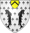 |
The arms of Cappelle-la-Grande are blazoned : Argent semy of cross-crosslets fitchy, 2 fesses sable, and in chief an inescutcheon Or a chevron sable.
|
See also
- Communes of the Nord department
- Cappelle-la-Grande Open
References
- "Répertoire national des élus: les maires". data.gouv.fr, Plateforme ouverte des données publiques françaises (in French). 9 August 2021.
- "Populations légales 2019". The National Institute of Statistics and Economic Studies. 29 December 2021.
- INSEE commune file
- Population en historique depuis 1968, INSEE
Wikimedia Commons has media related to Cappelle-la-Grande.
Authority control | |
|---|---|
| General | |
| National libraries | |
| Other |
|
This Nord geographical article is a stub. You can help Wikipedia by expanding it. |
На других языках
[de] Cappelle-la-Grande
Vorlage:Infobox Gemeinde in Frankreich/Wartung/abweichendes Wappen in Wikidata- [en] Cappelle-la-Grande
[ru] Каппель-ла-Гранд
Каппе́ль-ла-Гранд (фр. Cappelle-la-Grande) — коммуна во Франции, регион О-де-Франс, департамент Нор, округ Дюнкерк, кантон Кудкерк-Бранш. Пригород Дюнкерка (в 4 км к югу от центра города), в 4,5 км от автомагистрали А16 «Европейская». По границе коммуны проходит канал Бурбур.Текст в блоке "Читать" взят с сайта "Википедия" и доступен по лицензии Creative Commons Attribution-ShareAlike; в отдельных случаях могут действовать дополнительные условия.
Другой контент может иметь иную лицензию. Перед использованием материалов сайта WikiSort.org внимательно изучите правила лицензирования конкретных элементов наполнения сайта.
Другой контент может иметь иную лицензию. Перед использованием материалов сайта WikiSort.org внимательно изучите правила лицензирования конкретных элементов наполнения сайта.
2019-2026
WikiSort.org - проект по пересортировке и дополнению контента Википедии
WikiSort.org - проект по пересортировке и дополнению контента Википедии