world.wikisort.org - France
Marckolsheim (German: Markolsheim) is a commune in the Bas-Rhin department in Alsace in north-eastern France.[3]
This article may be expanded with text translated from the corresponding article in French. (December 2008) Click [show] for important translation instructions.
|
Marckolsheim
Màrkelse | |
|---|---|
Commune | |
 Barge in the lock beside the power station | |
 Coat of arms | |
Location of Marckolsheim  | |
 Marckolsheim  Marckolsheim | |
| Coordinates: 48°10′N 7°32′E | |
| Country | France |
| Region | Grand Est |
| Department | Bas-Rhin |
| Arrondissement | Sélestat-Erstein |
| Canton | Sélestat |
| Intercommunality | Ried de Marckolsheim |
| Government | |
| • Mayor (2020–2026) | Frédéric Pfliegersdoerffer[1] |
| Area 1 | 33.36 km2 (12.88 sq mi) |
| Population | 4,159 |
| • Density | 120/km2 (320/sq mi) |
| Time zone | UTC+01:00 (CET) |
| • Summer (DST) | UTC+02:00 (CEST) |
| INSEE/Postal code | 67281 /67390 |
| Elevation | 170–184 m (558–604 ft) |
| 1 French Land Register data, which excludes lakes, ponds, glaciers > 1 km2 (0.386 sq mi or 247 acres) and river estuaries. | |
On the eastern edge of the town the Casemate de Marckolsheim Sud, a Maginot Line fortification left over from the Second World War, has been converted into a small museum. Approximately 3 kilometres to the east the Rhine has been dammed and a hydro-electric power station installed.
Gallery
 Rue du Maréchal Foch near the townhall
 Rue du Maréchal Foch near Rue Clemenceau
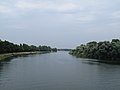 The Rhine near Marckolsheim


See also
References
- "Répertoire national des élus: les maires" (in French). data.gouv.fr, Plateforme ouverte des données publiques françaises. 13 September 2022.
- "Populations légales 2019". The National Institute of Statistics and Economic Studies. 29 December 2021.
- INSEE commune file
Wikimedia Commons has media related to Marckolsheim.
Authority control | |
|---|---|
| General |
|
| National libraries | |
| Other |
|
This Bas-Rhin geographical article is a stub. You can help Wikipedia by expanding it. |
На других языках
[de] Marckolsheim
Marckolsheim (auf Mundart Markelse, deutsch Markolsheim) ist eine französische Gemeinde mit 4159 Einwohnern (Stand 1. Januar 2019) im Département Bas-Rhin in der Region Grand Est (bis 2015 Elsass). Sie gehört zum Kanton Sélestat im Arrondissement Sélestat-Erstein und ist Mitglied sowie Sitz des 2012 gegründeten Gemeindeverbandes Ried de Marckolsheim.- [en] Marckolsheim
[ru] Маркольсайм
Маркольсайм (фр. Marckolsheim) — коммуна на северо-востоке Франции в регионе Гранд-Эст[1] (бывший Эльзас — Шампань — Арденны — Лотарингия), департамент Нижний Рейн, округ Селеста-Эрстен, кантон Селеста[2]. До марта 2015 года коммуна являлась административным центром одноимённого упразднённого кантона (округ Селеста-Эрстен).Текст в блоке "Читать" взят с сайта "Википедия" и доступен по лицензии Creative Commons Attribution-ShareAlike; в отдельных случаях могут действовать дополнительные условия.
Другой контент может иметь иную лицензию. Перед использованием материалов сайта WikiSort.org внимательно изучите правила лицензирования конкретных элементов наполнения сайта.
Другой контент может иметь иную лицензию. Перед использованием материалов сайта WikiSort.org внимательно изучите правила лицензирования конкретных элементов наполнения сайта.
2019-2026
WikiSort.org - проект по пересортировке и дополнению контента Википедии
WikiSort.org - проект по пересортировке и дополнению контента Википедии