world.wikisort.org - France
Bourges (French pronunciation: [buʁʒ] (![]() listen)) is a commune in central France on the river Yèvre. It is the capital of the department of Cher, and also was the capital city of the former province of Berry.
listen)) is a commune in central France on the river Yèvre. It is the capital of the department of Cher, and also was the capital city of the former province of Berry.
This article includes a list of general references, but it lacks sufficient corresponding inline citations. (March 2013) |
Bourges | |
|---|---|
Prefecture and commune | |
 Bourges Cathedral | |
 Flag  Coat of arms | |
Location of Bourges  | |
 Bourges  Bourges | |
| Coordinates: 47°05′04″N 2°23′47″E | |
| Country | France |
| Region | Centre-Val de Loire |
| Department | Cher |
| Arrondissement | Bourges |
| Intercommunality | CA Bourges Plus |
| Government | |
| • Mayor (2020–2026) | Yann Galut[1] |
| Area 1 | 68.74 km2 (26.54 sq mi) |
| Population | 64,541 |
| • Density | 940/km2 (2,400/sq mi) |
| Demonym(s) | Berruyers |
| Time zone | UTC+01:00 (CET) |
| • Summer (DST) | UTC+02:00 (CEST) |
| INSEE/Postal code | 18033 /18000 |
| Elevation | 120–169 m (394–554 ft) (avg. 153 m or 502 ft) |
| 1 French Land Register data, which excludes lakes, ponds, glaciers > 1 km2 (0.386 sq mi or 247 acres) and river estuaries. | |
History
The name of the commune derives either from the Bituriges, the name of the original inhabitants, or from the Germanic word Burg (French: bourg; Spanish: burgo; English, others: burgh, berg, or borough), for "hill" or "village". The Celts called it Avaricon; Latin-speakers: Avaricum. In the fourth century BC, as in the time of Caesar, the area around it was the center of a Gallic (Celtic) confederacy.
In 52 BC, the sixth year of the Gallic Wars, while the Gauls implemented a scorched-earth policy to try to deny Caesar's forces supplies, the inhabitants of Avaricum begged not to have their town burned.[citation needed] It was temporarily spared due to its good defences provided by the surrounding marshes, by a river that nearly encircled it, and by a strong southern wall. Julius Caesar's forces, nevertheless, captured and destroyed the town, killing all but 800 of its inhabitants.[citation needed]
Rome reconstructed Avaricum as a Roman town, with a monumental gate, aqueducts, thermae and an amphitheatre; it reached a greater size than it would attain during the Middle Ages. The massive walls surrounding the late-Roman town, enclosing 40 hectares, were built in part with stone re-used from earlier public buildings.
The third-century AD Saint Ursinus, also known as Saint Ursin, is considered[by whom?] the first bishop of the town. Bourges functions as the seat of an archbishopric. During the 8th century Bourges lay on the northern fringes of the Duchy of Aquitaine and was therefore the first town to come under Frankish attacks when the Franks crossed the Loire. The Frankish Charles Martel captured the town in 731, but Duke Odo the Great of Aquitaine immediately re-took it. It remained under the rule of counts who pledged allegiance to the Aquitanian dukes up to the destructive siege by the Frankish King Pepin the Short in 762, when Basque troops are found defending the town along with its count.

During the Middle Ages, Bourges served as the capital of the Viscounty of Bourges until 1101. In the fourteenth century, it became the capital of the Duchy of Berry (established in 1360). The future king of France, Charles VII (r. 1422–1461), sought refuge there in the 1420s during the Hundred Years' War. His son, Louis XI, was born there in 1423. In 1438, Charles VII decreed the Pragmatic Sanction of Bourges. During this period, Bourges was a major centre of alchemy.[citation needed]
The Gothic Cathedral of Saint Étienne, begun at the end of the twelfth century, ranks as a World Heritage Site. It is considered[by whom?] one of the earliest examples of the High Gothic style of the thirteenth century.[3]
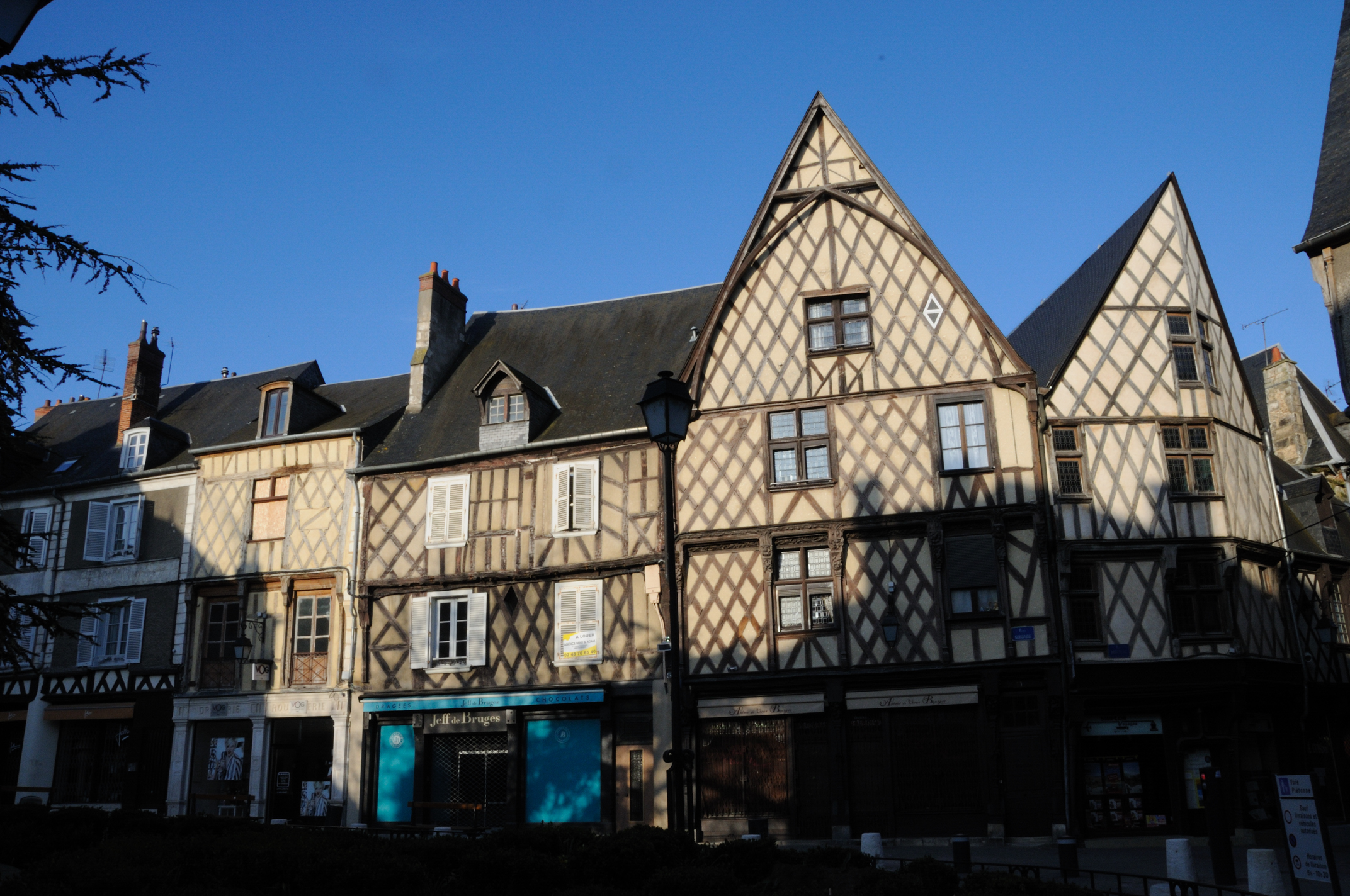
Bourges has a long tradition of art and history. Apart from the cathedral, other sites of importance include the 15th-century Palais Jacques Cœur and a sixty-five-hectare district of half-timbered houses and fine town-houses.
Population
|
| ||||||||||||||||||||||||||||||||||||||||||||||||||||||||||||||||||||||||||||||||||||||||||||||||||||||||||||||||||
| Source: EHESS[4] and INSEE (1968-2017)[5] | |||||||||||||||||||||||||||||||||||||||||||||||||||||||||||||||||||||||||||||||||||||||||||||||||||||||||||||||||||
Geography
Bourges sits at the river junction where the Auron flows into the Yèvre. The disused Canal de Berry follows alongside the course of the Auron through Bourges.
Climate
Bourges, located in the center of France, away from the Atlantic Ocean, features a typical degraded oceanic climate (Köppen: Cfb), characterized by colder, drier winters and warmer, wetter summers than the oceanic climate.
| Climate data for Bourges (Bourges Airport), elevation: 166 m or 545 ft, 1981-2010 normals | |||||||||||||
|---|---|---|---|---|---|---|---|---|---|---|---|---|---|
| Month | Jan | Feb | Mar | Apr | May | Jun | Jul | Aug | Sep | Oct | Nov | Dec | Year |
| Record high °C (°F) | 17.6 (63.7) |
22.6 (72.7) |
29.4 (84.9) |
29.4 (84.9) |
32.0 (89.6) |
38.0 (100.4) |
39.6 (103.3) |
39.9 (103.8) |
35.1 (95.2) |
31.7 (89.1) |
23.4 (74.1) |
20.0 (68.0) |
39.9 (103.8) |
| Average high °C (°F) | 6.9 (44.4) |
8.5 (47.3) |
12.5 (54.5) |
15.5 (59.9) |
19.6 (67.3) |
23.1 (73.6) |
26.0 (78.8) |
25.6 (78.1) |
21.8 (71.2) |
17.0 (62.6) |
10.7 (51.3) |
7.4 (45.3) |
16.3 (61.3) |
| Average low °C (°F) | 1.1 (34.0) |
1.1 (34.0) |
3.4 (38.1) |
5.3 (41.5) |
9.2 (48.6) |
12.4 (54.3) |
14.4 (57.9) |
14.1 (57.4) |
11.1 (52.0) |
8.3 (46.9) |
4.0 (39.2) |
1.8 (35.2) |
7.2 (45.0) |
| Record low °C (°F) | −20.4 (−4.7) |
−16.4 (2.5) |
−11.3 (11.7) |
−3.7 (25.3) |
−2.6 (27.3) |
3.4 (38.1) |
4.6 (40.3) |
4.6 (40.3) |
1.8 (35.2) |
−5.0 (23.0) |
−9.1 (15.6) |
−14.0 (6.8) |
−20.4 (−4.7) |
| Average precipitation mm (inches) | 55.2 (2.17) |
52.0 (2.05) |
53.2 (2.09) |
62.4 (2.46) |
78.6 (3.09) |
60.5 (2.38) |
66.1 (2.60) |
55.0 (2.17) |
59.7 (2.35) |
71.7 (2.82) |
65.7 (2.59) |
67.8 (2.67) |
747.9 (29.44) |
| Average precipitation days | 11.6 | 9.3 | 10.2 | 10.6 | 11.6 | 8.6 | 7.9 | 7.7 | 8.2 | 10.4 | 10.9 | 11.3 | 118.2 |
| Mean monthly sunshine hours | 67.9 | 88.6 | 151.0 | 175.7 | 210.0 | 224.9 | 239.0 | 232.7 | 185.8 | 124.5 | 72.2 | 55.3 | 1,827.5 |
| Source: Météo France[6][7] | |||||||||||||
| Climate data for Bourges (Bourges Airport), elevation: 166 m or 545 ft, 1961-1990 normals and extremes | |||||||||||||
|---|---|---|---|---|---|---|---|---|---|---|---|---|---|
| Month | Jan | Feb | Mar | Apr | May | Jun | Jul | Aug | Sep | Oct | Nov | Dec | Year |
| Record high °C (°F) | 17.0 (62.6) |
22.6 (72.7) |
24.4 (75.9) |
27.0 (80.6) |
29.8 (85.6) |
35.9 (96.6) |
38.5 (101.3) |
39.2 (102.6) |
35.1 (95.2) |
31.7 (89.1) |
21.6 (70.9) |
20.0 (68.0) |
39.2 (102.6) |
| Mean maximum °C (°F) | 10.2 (50.4) |
13.9 (57.0) |
15.2 (59.4) |
18.0 (64.4) |
23.0 (73.4) |
28.3 (82.9) |
30.0 (86.0) |
28.4 (83.1) |
26.2 (79.2) |
19.1 (66.4) |
13.5 (56.3) |
9.5 (49.1) |
30.0 (86.0) |
| Average high °C (°F) | 6.6 (43.9) |
8.2 (46.8) |
11.3 (52.3) |
14.6 (58.3) |
18.0 (64.4) |
21.8 (71.2) |
24.9 (76.8) |
24.3 (75.7) |
21.7 (71.1) |
16.9 (62.4) |
10.2 (50.4) |
7.3 (45.1) |
15.5 (59.9) |
| Daily mean °C (°F) | 3.7 (38.7) |
5.0 (41.0) |
7.1 (44.8) |
9.7 (49.5) |
13.1 (55.6) |
16.7 (62.1) |
18.9 (66.0) |
18.6 (65.5) |
16.1 (61.0) |
12.4 (54.3) |
6.9 (44.4) |
4.1 (39.4) |
11.0 (51.9) |
| Average low °C (°F) | 0.9 (33.6) |
1.3 (34.3) |
2.9 (37.2) |
4.9 (40.8) |
8.1 (46.6) |
11.1 (52.0) |
13.0 (55.4) |
12.9 (55.2) |
10.8 (51.4) |
8.1 (46.6) |
3.7 (38.7) |
1.1 (34.0) |
6.6 (43.8) |
| Mean minimum °C (°F) | −5.1 (22.8) |
−4.7 (23.5) |
−0.1 (31.8) |
2.5 (36.5) |
6.1 (43.0) |
8.6 (47.5) |
11.8 (53.2) |
11.0 (51.8) |
7.8 (46.0) |
4.6 (40.3) |
0.6 (33.1) |
−2.5 (27.5) |
−5.1 (22.8) |
| Record low °C (°F) | −20.4 (−4.7) |
−14.2 (6.4) |
−8.5 (16.7) |
−3.7 (25.3) |
−1.1 (30.0) |
3.4 (38.1) |
5.8 (42.4) |
4.8 (40.6) |
1.8 (35.2) |
−3.0 (26.6) |
−7.2 (19.0) |
−12.4 (9.7) |
−20.4 (−4.7) |
| Average precipitation mm (inches) | 61.7 (2.43) |
50.7 (2.00) |
62.6 (2.46) |
47.9 (1.89) |
85.2 (3.35) |
58.9 (2.32) |
51.5 (2.03) |
51.7 (2.04) |
54.8 (2.16) |
49.8 (1.96) |
58.7 (2.31) |
64.5 (2.54) |
698 (27.49) |
| Average precipitation days (≥ 1.0 mm) | 11.7 | 10.5 | 11.1 | 9.7 | 12.5 | 8.9 | 7.3 | 7.7 | 8.1 | 9.2 | 10.5 | 11.2 | 118.4 |
| Average snowy days | 3.9 | 3.6 | 2.5 | 1.0 | .1 | 0 | 0 | 0 | 0 | 0 | 1.5 | 2.7 | 15.3 |
| Average relative humidity (%) | 87 | 82 | 76 | 73 | 76 | 74 | 69 | 71 | 75 | 84 | 87 | 88 | 79 |
| Mean monthly sunshine hours | 56.9 | 85.4 | 137.8 | 175.9 | 199.6 | 229.4 | 260.3 | 230.4 | 185.5 | 133.6 | 77.3 | 59.7 | 1,831.8 |
| Percent possible sunshine | 21.0 | 30.0 | 38.0 | 44.0 | 43.0 | 49.0 | 55.0 | 53.0 | 50.0 | 40.0 | 28.0 | 23.0 | 39.5 |
| Source 1: NOAA[8] | |||||||||||||
| Source 2: Infoclimat.fr (humidity)[9] | |||||||||||||
Sights

- Its Gothic cathedral (built 1195–1255) was added to the list of the World Heritage Sites by UNESCO in 1992
- Palais Jacques Cœur[10]
- Lallemant's hotel, from the early French Renaissance[11]
- The Berry museum, located in the Cujas' hotel[12]
- The Estève museum, located in the so-called aldermen's hotel[13]
- The marshes of the Yèvre and Voiselle rivers were listed in 2003 as a French Natural Monument or Site[14]
- The ruins of the Gallo-Roman walls
- The Conservatoire national du Pélargonium
Transport
The Bourges station offers direct railway connections to Orléans, Tours, Lyon and several regional destinations. The A71 motorway connects Bourges with Orléans and Clermont-Ferrand. Bourges Airport is a small regional airport.
Sport and recreation
Bourges' principal football team are Bourges Football 18. It is also home to the women's basketball club CJM Bourges Basket, which has won multiple titles in domestic and European basketball. Bourges XV is the premier rugby team in the region, currently playing in French National Division, Federal 3.
Colleges and universities
Twin towns – sister cities
Bourges is twinned with:[15]
 Augsburg, Germany
 Aveiro, Portugal
 Forlì, Italy
 Koszalin, Poland
 Palencia, Spain
 Peterborough, United Kingdom
 Yoshkar-Ola, Russia
 Korosten, Ukraine
Events
The Printemps de Bourges music festival takes place in Bourges every year.
Every summer, and since 2002, Les mille univers hosts a writing workshop in collaboration with Oulipo.[16]
Personalities
- 16th-century poet and translator Pierre Motin was born in Bourges.
- 17th-century composer and singer François Bourgoing was born in Bourges.
- The merchant Jacques Cœur was born in Bourges.
- The manuscript illuminator Jean Colombe maintained a workshop in Bourges.
- John Calvin was a student in the University of Bourges.
- The legal expert Jacques Cujas lived in Bourges during 1555-1557 and 1575–1590.
- Eustadiola (594–684) was a saint and abbess.
- The Impressionist painter Berthe Morisot was born in Bourges on 14 January 1841.
- The Art Nouveau sculptor Julien Caussé was born in Bourges in 1869.
- The philosopher Vladimir Jankélévitch (1903-1985) was born in Bourges.
- The writer and historian Jules Bertaut (1877–1959) was born in Bourges.
- Béatrice Vialle, aviator.
- Emmanuel Imorou, footballer.
- Émilienne Demougeot (1910–1994), historian, was born in Bourges.
- The mother of fictional character Gabrielle Maple hailed from Bourges in The Petrified Forest (1936), endearingly mispronounced "Boorgs" by the actress playing the part, Bette Davis.
- François Jacques (1946–1992), historian, was born in Bourges.
- Arnaud Courlet de Vregille (1958-), painter, was born in Bourges.
See also
References
- "Répertoire national des élus: les maires". data.gouv.fr, Plateforme ouverte des données publiques françaises (in French). 2 December 2020.
- "Populations légales 2019". The National Institute of Statistics and Economic Studies. 29 December 2021.
- Destination 360 (Accessed 7 October 2016) Cathedral one of the earliest examples of High Gothic.
- Des villages de Cassini aux communes d'aujourd'hui: Commune data sheet Bourges, EHESS. (in French)
- Population en historique depuis 1968, INSEE
- "Données climatiques de la station de Bourges" (in French). Meteo France. Retrieved 30 December 2015.
- "Climat Centre-Val de Loire" (in French). Meteo France. Retrieved 30 December 2015.
- "Bourges (07255) - WMO Weather Station". NOAA. Retrieved 3 April 2019.
- "Normes et records 1961-1990: Bourges (18) - altitude 161m" (in French). Infoclimat. Retrieved 30 December 2015.
- Jacques Cœur's palace, visitor centre Archived 21 April 2013 at the Wayback Machine
- Lallemant's hotel, visitor centre Archived 4 March 2016 at the Wayback Machine
- Berry museum, visitor center Archived 7 May 2016 at the Wayback Machine
- Estève museum, visitor centre Archived 5 March 2016 at the Wayback Machine
- Bourges' marshes, visitor centre
- "Villes jumelles". ville-bourges.fr (in French). Bourges. Retrieved 12 November 2019.
- Les récréations à Bourges.
Bibliography
External links
| |||||
|
Authority control | |
|---|---|
| General | |
| National libraries | |
| Other | |
На других языках
- [en] Bourges
[ru] Бурж
Бурж (фр. Bourges, лат. Avaricum Biturigum) — главный город департамента Шер во Франции, на реке Йевре (фр.) (рус. и Беррийском канале (англ.) (рус.. Исторически — столица провинции Берри и герцогства Беррийского. Население — 68 980 жителей (2008).Другой контент может иметь иную лицензию. Перед использованием материалов сайта WikiSort.org внимательно изучите правила лицензирования конкретных элементов наполнения сайта.
WikiSort.org - проект по пересортировке и дополнению контента Википедии