world.wikisort.org - France
Vannes (French pronunciation: [van] (![]() listen); Breton: Gwened) is a commune in the Morbihan department in Brittany in north-western France. It was founded over 2,000 years ago.[3]
listen); Breton: Gwened) is a commune in the Morbihan department in Brittany in north-western France. It was founded over 2,000 years ago.[3]
This article's lead section may be too short to adequately summarize the key points. (May 2020) |
Vannes
Gwened | |
|---|---|
Prefecture and commune | |
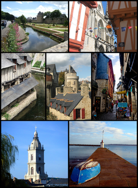 Montage of Vannes Top left: View of Ramparts Garden of Vannes and Gaillard Castle Museum; Top right: Saint Peters Cathedral; Middle left: Vieux lavoirs, old washing place; Center: Connetable Tower; Middle right: Intra Muros narrow street; Bottom left: Saint Paterne Church; Bottom right: Conleau Pier | |
 Flag  Coat of arms | |
Location of Vannes  | |
 Vannes  Vannes | |
| Coordinates: 47°39′21″N 2°45′37″W | |
| Country | France |
| Region | Brittany |
| Department | Morbihan |
| Arrondissement | Vannes |
| Canton | Vannes-1, 2 and 3 |
| Intercommunality | Golfe du Morbihan - Vannes Agglomération |
| Government | |
| • Mayor (2020–2026) | David Robo[1] |
| Area 1 | 32.3 km2 (12.5 sq mi) |
| Population | 53,719 |
| • Density | 1,700/km2 (4,300/sq mi) |
| Time zone | UTC+01:00 (CET) |
| • Summer (DST) | UTC+02:00 (CEST) |
| INSEE/Postal code | 56260 /56000 |
| Elevation | 0–56 m (0–184 ft) (avg. 22 m or 72 ft) |
| 1 French Land Register data, which excludes lakes, ponds, glaciers > 1 km2 (0.386 sq mi or 247 acres) and river estuaries. | |
History
Celtic Era
The name Vannes comes from the Veneti, a seafaring Celtic people who lived in the south-western part of Armorica in Gaul before the Roman invasions. The region seems to have been involved in a cross channel trade for thousands of years, probably using hide boats and perhaps Ferriby Boats.[4] Wheat that apparently was grown in the Middle East was part of this trade.[5] At about 150 BC the evidence of trade (such as Gallo-Belgic coins) with the Thames estuary area of Great Britain dramatically increased.[6]
Roman Era
The Veneti were defeated by Julius Caesar's fleet in 56 BC in front of Locmariaquer; many of the Veneti were then either slaughtered or sold into slavery. The Romans settled a town called Darioritum in a location previously belonging to the Veneti.
The Britons arrive
From the 5th to the 7th century, the remaining Gauls were displaced or assimilated by waves of immigrant Britons fleeing the Saxon invasions of Britain. Under the Breton name Gwened (also derived from the Veneti), the town was the center of an independent principality or kingdom variously called Bro-Wened ("Vannes") or Bro-Ereg ("land of Gwereg"), the latter for a prominent member of its dynasty, which claimed descent from Caradog Strongarm. The diocese of Vannes was erected in the 5th century. The Council of Vannes was held there in 461. The realm annexed Cornouaille for a time in the early 6th century but was permanently joined with Domnonia under its king and Saint Judicaël around 635.
Breton War of Succession
In 1342, Vannes was besieged four times between forces from both sides of the Breton War of Succession. The city's defending commander, Olivier IV de Clisson, was captured by the English but finally released. The French eventually executed him since they suspected him of being a traitor since the ransom was unusually low.
18th century
In 1759, Vannes was used as the staging point for a planned French invasion of Britain. A large army was assembled there, but it was never able to sail after the French naval defeat at the Battle of Quiberon Bay in November 1759.
In 1795, during the French Revolution, French forces based in Vannes successfully repelled a planned British-Royalist invasionthrough Quiberon.
Geography
Vannes, located on the Gulf of Morbihan at the mouth of two rivers, the Marle and the Vincin, is around 100 kilometres (62 miles) northwest of Nantes and 450 km (280 miles) south west of Paris. Vannes is a market town linked to the sea.
Climate
| Climate data for Vannes / 1981–2010 normals, extremes 1998–present | |||||||||||||
|---|---|---|---|---|---|---|---|---|---|---|---|---|---|
| Month | Jan | Feb | Mar | Apr | May | Jun | Jul | Aug | Sep | Oct | Nov | Dec | Year |
| Record high °C (°F) | 16.7 (62.1) |
20.2 (68.4) |
23.7 (74.7) |
27.1 (80.8) |
29.9 (85.8) |
36.0 (96.8) |
37.0 (98.6) |
38.3 (100.9) |
32.1 (89.8) |
28.5 (83.3) |
20.6 (69.1) |
16.4 (61.5) |
38.3 (100.9) |
| Average high °C (°F) | 9.5 (49.1) |
10.5 (50.9) |
13.0 (55.4) |
15.6 (60.1) |
18.6 (65.5) |
22.3 (72.1) |
23.5 (74.3) |
23.5 (74.3) |
21.7 (71.1) |
17.3 (63.1) |
12.9 (55.2) |
9.6 (49.3) |
16.5 (61.7) |
| Daily mean °C (°F) | 6.5 (43.7) |
7.0 (44.6) |
8.9 (48.0) |
11.1 (52.0) |
14.3 (57.7) |
17.4 (63.3) |
18.9 (66.0) |
18.6 (65.5) |
16.5 (61.7) |
13.4 (56.1) |
9.3 (48.7) |
6.4 (43.5) |
12.4 (54.3) |
| Average low °C (°F) | 3.6 (38.5) |
3.5 (38.3) |
4.8 (40.6) |
6.6 (43.9) |
10.0 (50.0) |
12.5 (54.5) |
14.2 (57.6) |
13.7 (56.7) |
11.3 (52.3) |
9.6 (49.3) |
5.8 (42.4) |
3.1 (37.6) |
8.3 (46.9) |
| Record low °C (°F) | −7.4 (18.7) |
−7.3 (18.9) |
−8.6 (16.5) |
−2.6 (27.3) |
−0.6 (30.9) |
3.7 (38.7) |
7.0 (44.6) |
6.2 (43.2) |
2.5 (36.5) |
−1.5 (29.3) |
−5.8 (21.6) |
−7.1 (19.2) |
−8.6 (16.5) |
| Average precipitation mm (inches) | 99.8 (3.93) |
71.2 (2.80) |
76.8 (3.02) |
70.6 (2.78) |
62.8 (2.47) |
36.8 (1.45) |
56.8 (2.24) |
50.3 (1.98) |
60.2 (2.37) |
105.7 (4.16) |
105.3 (4.15) |
111.6 (4.39) |
907.9 (35.74) |
| Average precipitation days (≥ 1 mm) | 14.0 | 10.0 | 11.2 | 10.7 | 10.3 | 6.5 | 8.5 | 7.9 | 7.7 | 13.2 | 12.7 | 12.6 | 125.1 |
| Mean monthly sunshine hours | 74.6 | 102.2 | 151.5 | 189.9 | 203.9 | 252.3 | 246.3 | 218.5 | 207.6 | 116.5 | 91.8 | 84.4 | 1,939.4 |
| Source: Meteociel[7] | |||||||||||||
Transport
Train
The Vannes railway station offers connections to Quimper, Rennes, Nantes, Paris and several regional destinations.
With the fast train TGV, the journey takes:
– 30 minutes to Lorient,
– 1 hour to Nantes or Rennes,
– 2.5 to 4 hours to Paris.
The Transport express régional or TER is a slower train to join railway stations in the close neighborhood, such as Auray or Questembert.
There is no direct line from Vannes to Saint-Brieuc (118 km away in the north of Brittany), so the train from Vannes to Saint Brieuc goes via Rennes, which doubles the travel time and cost: it takes 2 to 3 hours to go from Vannes to Saint Brieuc by train.
Car
Two highways, in the north of Vannes, provide fast connections by car:
– N165: west to Lorient (58 km) and Quimper (122 km), south east to Nantes (111 km)
– N166: north east to Rennes (113 km)
+ a network of small roads connects Vannes to smaller cities.
There is no highway from Vannes to Saint-Brieuc, so the way to northern Brittany consists of small roads. The lack of highway or railway between Vannes and Saint-Brieuc (118 km north) cuts the communications between northern and southern Brittany, and limits Brittany economic performance.
Airplanes
Vannes has a small airfield in the village of Monterblanc, called Vannes-Meucon airport, or "Vannes – Golfe du Morbihan airport". It used to be a military airport, but it is now dedicated to general aviation aircraft. It belongs to Vannes Agglomeration community, the group of cities gathered around Vannes, and the main users of this airfield are Vannes flying club, the local ultralight aviation club, and Vannes school of skydiving.
Bus
There are 2 bus networks in Vannes:
– Kicéo, proposes short travels starting from Vannes Place de la Republique on behalf of Vannes Agglomeration community,
– CAT, propose longer travel starting from the railway station on behalf of Morbihan.
So there are 2 central bus stations in Vannes: one on Place de la Libération, the other at the railway station.
Bike
Vannes has a public bicycle rental program, called Vélocéo based on the same idea as the Paris Vélib'.
Hundreds of bicycles are available across 10 automated rental stations each with 10 to fifteen bikes/spaces.[8]
Each Vélocéo service station is equipped with an automatic rental terminal and stands for bicycles.
This replaces the Velocea service, which was discontinued in August 2017.[9]
Population
Inhabitants of Vannes are called Vannetais.
|
| ||||||||||||||||||||||||||||||||||||||||||||||||||||||||||||||||||||||||||||||||||||||||||||||||||||||||||||||||||
| Source: EHESS[10] and INSEE (1968-2017)[11] | |||||||||||||||||||||||||||||||||||||||||||||||||||||||||||||||||||||||||||||||||||||||||||||||||||||||||||||||||||
Monuments and sights

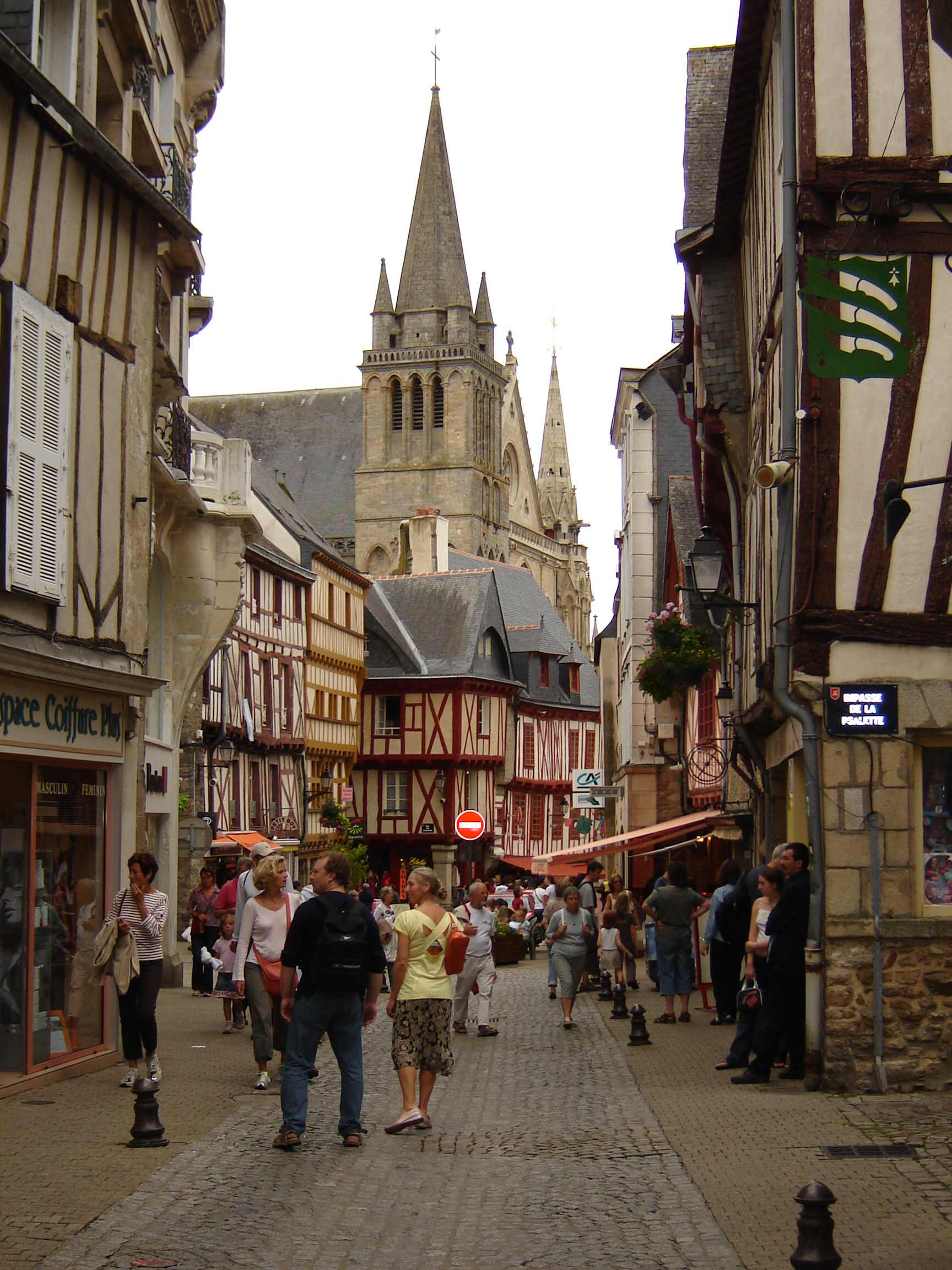
- Cathedral of St Peter, Gothic cathedral
- Church of St Patern, classic church
- Chapel of Saint-Yves, baroque church
- Château Gaillard (medieval house now used as an archaeological museum)
- Musée de la Cohue (fine arts museum)
- Hôtel de Ville
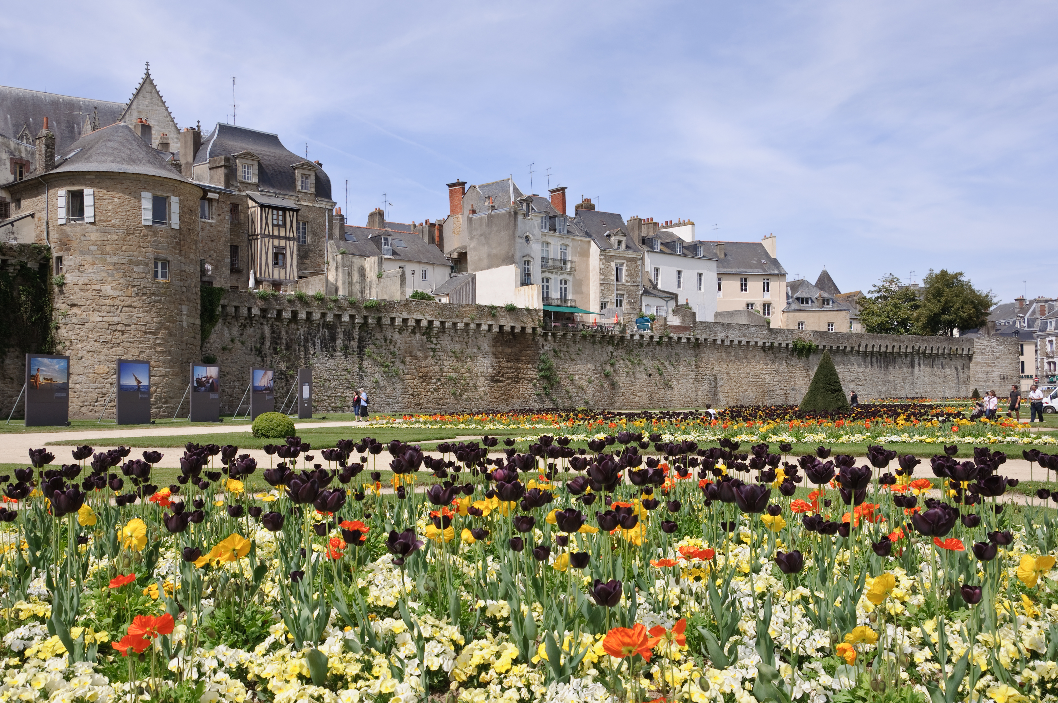
- Old city walls, which include :
- Tour du Connétable (a large medieval tower part of the old city walls)
- Château de l'Hermine (former castle, transformed into a palace in the 17th century, and a residence of the Dukes of Brittany between the 13th and 16th centuries)
- Porte Calmont, medieval city gate
- Porte Prison, medieval city gate
- Porte Poterne, medieval city gate
- Porte Saint-Jean, medieval city gate
- Porte Saint-Vincent, 18th century city gate
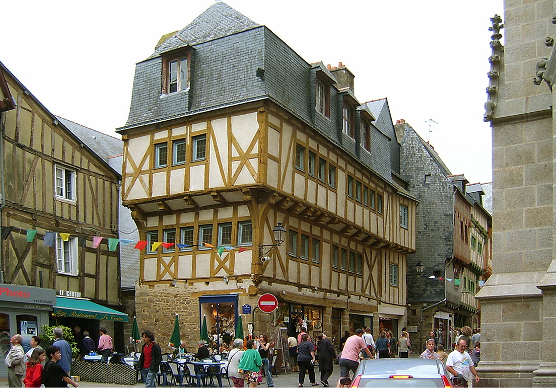
- Many timber-framed houses in the old town
- "Vannes and his wife", a funny painted granite sculpture from the 15th century in front of Château Gaillard
- The harbour
Education
- École nationale supérieure d'ingénieurs de Bretagne Sud
- Institut catholique d'arts et métiers
- Southern Brittany University
Breton language
The municipality launched a linguistic plan through Ya d'ar brezhoneg on 12 October 2007. In 2008, 7.71% of children attended the bilingual schools in primary education.[12]
In fiction
- In the last of the Three Musketeers novels of Alexandre Dumas, The Vicomte of Bragelonne: Ten Years Later, published in 1847, the musketeer Aramis appears as bishop of Vannes before becoming General of the Society of Jesus.
- In Sébastien Roch, a novel by Octave Mirbeau published in 1890, Sebastien is sent to a school in Vannes, Saint-François-Xavier, where he is a victim of sexual abuse.
- In Sir Nigel, a novel by Sir Arthur Conan Doyle published in 1906, Nigel is made seneschal of the Castle of Vannes after a battle in Brittany. He doesn't remain in Vannes, since after winning in another battle, the Black Prince dubs him a knight and Nigel returns to England to wed the Lady Mary.
- Jean-François Parot has written a series of crime fictions printed up to 2010 taking place in the 18th century, whose main character is Nicolas Le Floch, a Police Commissioner who was also educated in the school of Saint François-Xavier in Vannes, but he didn't share Sebastien Roch's misfortune. The Nicolas Le Floch novels have been adapted as a television series.
- In The Secret of the Missing Boat, a children's book by Paul Berna published in 1966 as La Voile Rouge.
- In "Charlemagne and Florent," a short story by Ranylt Richildis published in 2014 by Myths Inscribed.
- Vannes is a major location in C.J. Adrien's novel The Oath of the Father, published in 2015, about the Viking raids in Brittany.
Notable people
- Albinus of Angers (born 469), Roman Catholic saint
- Saint Emilion (Emilianus) (?–767), monk and Roman Catholic saint, he gave his name to one of the main red wine areas of Bordeaux
- François I (1414–1450), Duke of Brittany
- Louis-Marie Autissier (1772–1830), painter
- Armand Alexandre de Castagny (1807–1900), military general
- Louise Bourgoin (born 1981), actress
- Pierre de La Gorce (1846–1934), historian
- Paul César Helleu (1859–1927), painter
- Émile Jourdan (1860–1931), painter of Pont-Aven School
- Louis Martin-Chauffier (1894–1980), writer, journalist and member of the French Resistance
- Yves Rocard (1903–1992), physicist
- Colonel Rémy (1904–1984), secret agent of the French Resistance
- Alain Resnais (1922–2014), film director
- Jean Vezin (1933–2020), palaeographer
- Yves Coppens (born 1934), paleontologist
- Serge Latouche (born 1940), economist
- Cédric Morgan (born 1943), writer, winner of the Prix Breizh in 2015
- Claude-Michel Schönberg (born 1944), singer and songwriter
- Bernard Poignant (born 1945), politician
- Hélène de Fougerolles (born 1973), actress
- Mathieu Berson (born 1980), footballer
- Joris Marveaux (born 1982), footballer
- Sylvain Marveaux (born 1986), footballer
- Yann Kermorgant (born 1981), footballer
- Jeremy Callaghan, Australian actor and writer[13]
Sport
The local football team is Vannes OC, members of the Championnat de France de Ligue 2 for the 2009–10 season.
The Rugby Club Vannes is the rugby union team and competed in Pro D2 for the 2015–16 season.
Both teams play at the Stade de la Rabine built in 2001.
The town was the start line for stage 9 of the 2015 Tour de France.
Twin towns – sister cities
Vannes is twinned with:[14]
 Mons, Belgium (1952)
 Cuxhaven, Germany (1963)
 Fareham, England, United Kingdom (1967)
 Wałbrzych, Poland (2001)
 Ballymoney, Northern Ireland, United Kingdom (2001)
See also
- Saint-Vincent Gate (Vannes)
- Veneti (Gaul)
- Saint Meriasek
- Operation Dingson
- Communes of the Morbihan department
- Pierre Marie François Ogé Sculpture in Vannes town hall.
- Eleanor, a Nile crocodile resident of the Aquarium du Vannes.
Gallery
 Panorama of the old town
 In the old town centre
 Place des Lices
 Old washing-places
 Château de l'Hermine
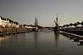 Port de Vannes
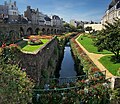 Garden of the Château de l'Hermine
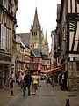 Street in town center
 Vannes Cathedral
 St. Patern church
 The port, at the foot of St. Vincent gate


References
- "Maires du Morbihan" (PDF). Préfecture du Morbihan. 7 July 2020.
- "Populations légales 2019". The National Institute of Statistics and Economic Studies. 29 December 2021.
- History of Vannes Archived 24 October 2007 at the Wayback Machine Official website of the city
- Cunliffe, Barry (2008). Britain and the continent: networks of interaction. A Companion to Roman Britain. John Wiley & Sons. pp. 1–11.
- Balter, Michael. "DNA recovered from underwater British site may rewrite history of farming in Europe". Science News. Science. Retrieved 16 March 2015.
- Cunliffe, Barry (2008). Britain and the continent: networks of interaction." A Companion to Roman Britain. John Wiley & Sons. p. 528. ISBN 9780470998854.
- "Normales et records pour Vannes-Sene (56)". Meteociel. Retrieved 14 September 2020.
- "Vélocéo". veloceo.kiceo.fr. Retrieved 27 September 2020.
- "Vélocéo. Premiers coups de pédales le 9 juin". Le Telegramme (in French). 25 May 2018. Retrieved 27 September 2020.
- Des villages de Cassini aux communes d'aujourd'hui: Commune data sheet Vannes, EHESS. (in French)
- Population en historique depuis 1968, INSEE
- (in French) Ofis ar Brezhoneg: Enseignement bilingue
- "Restoration of a classic French apartment". homestolove.com.au. 18 October 2016. Retrieved 12 May 2020.
- "Relations internationales". mairie-vannes.fr (in French). Vannes. Retrieved 13 April 2021.
External links
- Official web site of the city
 Vannes travel guide from Wikivoyage
- Base Mérimée: Search for heritage in the commune, Ministère français de la Culture. (in French)
| |||||
|
Authority control | |
|---|---|
| General | |
| National libraries | |
| Other | |
На других языках
[de] Vannes
Vannes (bretonisch Gwened) ist eine französische Stadt und Gemeinde mit 53.719 Einwohnern (Stand: 1. Januar 2019) und die Hauptstadt des Départements Morbihan in der Region Bretagne.- [en] Vannes
[es] Vannes
Vannes (en bretón, Gwened)[6] es una localidad y comuna francesa, capital del departamento de Morbihan, en la región de Bretaña.[fr] Vannes
Vannes /van/[Note 1] .mw-parser-output .prononciation>a{background:url("//upload.wikimedia.org/wikipedia/commons/thumb/8/8a/Loudspeaker.svg/11px-Loudspeaker.svg.png")center left no-repeat;padding-left:15px;font-size:smaller}Écouter est une commune française située dans l’ouest de la France sur la côte sud de la région Bretagne. La ville, située en Basse-Bretagne, est la préfecture du département du Morbihan, et le siège d'une agglomération de 79 795 habitants. Centre économique et destination touristique[1] à la tête d’une aire urbaine de 158 549 habitants au 1er janvier 2017[i 1], et d'une population municipale de 53 218 habitants au 1er janvier 2016[i 2], Vannes est la 4e agglomération de la région Bretagne[i 3] en nombre d'habitants, et le 3e pôle universitaire de Bretagne[2].[ru] Ван (город, Франция)
Ван[1][2][3], или Ванн[4][5][6][7] (фр. Vannes, брет. Gwened) — город на северо-западе Франции, находится в регионе Бретань, префектура департамента Морбиан, центр округа Ван и кантонов Ван-1, Ван-2 и Ван-3. Расположен в 110 км к юго-западу от Ренна и к северо-западу от Нанта, в месте впадения рек Марль и Венсен в залив Морбиан. В Ване начинается национальная автомагистраль N166. В северной части города находится железнодорожная станция Ван линии Савене—Ландерно.Другой контент может иметь иную лицензию. Перед использованием материалов сайта WikiSort.org внимательно изучите правила лицензирования конкретных элементов наполнения сайта.
WikiSort.org - проект по пересортировке и дополнению контента Википедии